 Nearly a century ago, the American involvement in the 1918 Meuse-Argonne Offensive still ranks as the bloodiest battle in US history.
Had the commanders in that battle possessed the geospatial tools of today, could they have saved lives then? Could they have quickened victory?
Plan a Historic Battle with Military Tools is a new Learn ArcGIS lesson demonstrating how you, an intelligence analyst preparing for the battle, could have used Military Tools for ArcGIS to save lives and hasten victory.
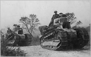
This four-lesson project, using ArcGIS Pro, starts with exploring Military Tools for ArcGIS. You’ll then use the Military Symbol Editor to draw the infantry regiments, from the US and Imperial German Army, that faced each other across no man’s land on Oct. 7, 1918. The Distance and Direction tool will enable you to determine whether the tanks of the World War I era could keep pace with the US infantry during its assault. Finally, you’ll use the Visibility tool to identify the best location to position your forward observers, who act as the eyes of the artillery.
Each lesson concludes with an instructional video featuring the military tools used in that lesson. The first lesson includes on overview video for Military Tools for ArcGIS.

Article Discussion: