Summary: Building Scene Layer has been updated to version 1.7 in the I3S specification. With building scene layers you can share BIM 3D models on the web and use them for visualization and interactive analysis such as view shade analysis or explore the interior of the building.
Scene layers enable users to share and work with large volumes of 3D content across the ArcGIS platform. As part of our ongoing work, we have updated the Indexed 3D Scene Layer (I3S) specification to add new data types and performance improvements. Scene layers may contain different data types based upon geometry and source content, including points, point clouds, integrated meshes, 3D objects, and building content from BIM. The scene layer types may evolve independently from each other.
A version of the I3S specification was released in July 2019 that improves performance for integrated mesh and 3D object scene layers. Currently ArcGIS Pro, the Scene Viewer in ArcGIS Online, and the ArcGIS API for JavaScript version 4.14 support the 1.7 specification. ArcGIS Enterprise 10.8 will also support this version of the spec at release. In performance testing, we saw scene layers draw up to 4 times faster than in previous versions. To reach this performance improvements the following changes were introduced:
- Node pages – Nodes are grouped into pages. Clients can determine which node pages they need, and request only the necessary pages. This significantly reduces server-client traffic and improves performance.
- Draco geometry compression – This allows us to create compact nodes, which in turn provides a smaller payload and improves performance.
You can find more details about I3S 1.7 specification updates at this link: https://www.esri.com/arcgis-blog/products/arcgis-pro/3d-gis/i3s-specification-1-7-updates/
Version 1.7 is backward compatible. Older clients can read scene layers but will not benefit from performance improving features of newer data. As of December 2019, the newer building scene layer also supports 1.7 specification improvements.
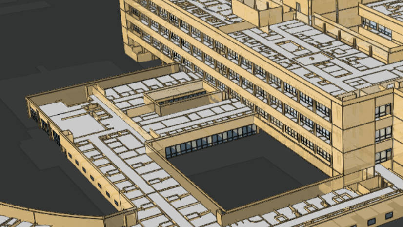
Building scene layer version 1.7
A building scene layer is a 3D representation of a building model. A building model may be derived from 3D construction content, such as BIM data, or even from a relational database model that contains 3D spatial information. The building scene layer attempts to model the organization of construction data and groups content into standard engineering disciplines. Content in a building scene layer may represent a partial building, an individual building, or multiple buildings on a campus.
Interested in more in learning more about BIM and GIS integration? See Chris Andrews blog about BIM and GIS integration. The building scene layer captures standard disciplines such as Mechanical, Architectural, Piping, Electrical, and Structural. Within each discipline, the building scene layer groups category layers containing 3D objects representing assets of the building such as doors, windows, pipes and walls. The assets can contain attributes that directly reflect standard and user defined metadata that are stored in the source BIM content or geodatabase. You can learn more about the current capabilities in ArcGIS Pro like creating a building layer from Autodesk REVIT , creating a building scene layer or working with building scene layers in the Scene viewer.
A building is more than just its individual parts, when a building scene layer is created the category layers are processed in spatial relationship to each other. For example, when viewing a building very small assets such as fire alarm devices might not be visible from a specific viewing distance but larger objects such as windows and doors do need to be visible. A building scene layer created in this workflow allows for better performance than would be observed by representing a building using more loosely organized 3D object scene layers.

You can create building scene layers in ArcGIS Pro 2.5 using the geoprocessing tool, Create Building Scene Layer. If you have an older building scene layer SLPK produced with ArcGIS Pro 2.4, you can upgrade it to the latest I3S specification using the i3s-converter tool.
What else has changed in the latest update?
Thanks to the feedback we are receiving about the I3S specification we are continuing to improve the documentation to make is easier for 3rd party vendors and users to write and read scene layers. We have added examples for each scene layer types in the Read Me files for the different scene layer types. You can inspect SLPK or services to understand I3S better. We also added more examples to the documentation of individual objects.
The I3S converter has been updated to validate and create building scene layers as well. Use this tool to updated existing SLPK.
What comes next?
I3S is a living specification in active use by Esri and our partners and customers. Thousands of scene layers have already been created on ArcGIS online and enterprise. We are constantly looking at improvements to help our users do more with I3S, such as:
- We are working on tools to update older published scene layers to the new 1.7 specification.
- The I3S converter is only available as an individual executable. We plan to make it more convenient and add it as a geoprocessing tool in ArcGIS Pro.
- We want to make it easier for 3rd party vendors to upgrade to 1.7 or future versions. Therefore, we are currently working on an I3S SDK that can be integrated into existing pipelines for creating I3S.
- Point scene layers will be updated to 1.7.
If you have more ideas on how to improve scene layers, please go to our public GitHub repo and enter an issue.

Commenting is not enabled for this article.