Voxel Scene Layers
Voxel layers were first introduced a few releases ago. Since then many users have been asking to share voxel layers to ArcGIS Online and ArcGIS Enterprise and now the time has come! At this release you can now create voxel scene layer packages using the Create Voxel Scene Layer Content geoprocessing tool. These packages can be visualized in ArcGIS Pro or uploaded and published to ArcGIS Enterprise 10.9.1 and ArcGIS Online.
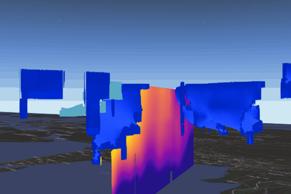
Note: The Scene Viewer in ArcGIS Enterprise 10.9.1 and ArcGIS Online does not currently support viewing voxel layers so voxel web scene layers can only be viewed in ArcGIS Pro or in a custom ArcGIS API for Javascript application.
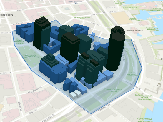
Clip Scene Layers
You may have received a scene layer package that was very large and you wanted to clip the scene layer to a specific area of interest. At ArcGIS Pro 2.9 we added support for additional scene layer types in the clip geoprocessing tool. In the previous release we added support for clipping integrated meshes. In this release we have added support for clipping point cloud and 3D object scene layer packages. Clipping is still not supported for voxel, point, or building scene layer packages but we are working on this! Keep in mind when a 3D object scene layer package is clipped the entire building will be in the output as we do not cut buildings in half.
Scene Layer Content
At ArcGIS Pro 2.9, we renamed all of the labels on our geoprocessing tools as we are supporting more formats. Scene layer content includes both scene layer packages (.slpk) as well as i3sREST. The Create 3D Object, Point, and Building content tools support choosing a cloud connection to write i3sREST or output to a scene layer package. Additional tools will add support for i3sREST in the next release of ArcGIS Pro.
The .i3sREST format is based on JSON, REST, and modern web standards. The .i3sREST format is optimized for web clients to handle, parse, and render when stored in cloud stores such as Amazon S3, Azure Blob stores, Alibaba OSS, or Google Cloud. The .i3sREST format is served directly from the data store, allowing improved scalability in ArcGIS Enterprise.
The ready-to-serve .i3sREST format is best suited for scene layer content larger than 200 GB. You can create .i3sREST in ArcGIS Pro. After the scene layer content is available in the cloud store, you can publish it as a scene layer using ArcGIS API for Python to ArcGIS Enterprise 10.8.1 and later.

Create Mobile Scene Package tool enhancements
We continue to add data management and productivity improvements to the Create Mobile Scene Package tool to make easier to create mobile scene packages and visualize them in ArcGIS Runtime clients such as ArcGIS Earth and ArcGIS Earth Mobile. At the 2.9 release the create mobile scene package tool now supports clipping and projecting scene layer packages. Vector tile packages and services are also now supported in a mobile scene package. ArcGIS Runtime 100.13 apps and later can consume these mobile scene packages. With this support you can reference additional basemaps if you’ve enabled the Reference Online Content parameter. These enhancements support more hyrbid online/offline workflows as well as continuing to support the offline only workflows.

Article Discussion: