The scene layers team has been working on exciting new functionality for the ArcGIS Pro 3.2 release. Let’s take a look at some of these new features!
3D basemaps
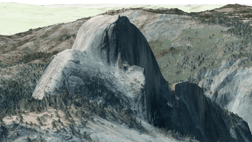
In local and global scenes, ArcGIS Pro supports adding 3D basemaps. Easily access this new functionality by opening a 3D scene and choosing one of the provided 3D basemaps in the basemaps dialog. Be sure to have an active portal connection to ArcGIS Online to access this functionality!

Once you have chosen a 3D basemap you will have access to a global 3D dataset based on open street map data. This includes realistic and thematic trees, untextured buildings and places and labels. For optimal performance, the 3D features will render once you zoom in.
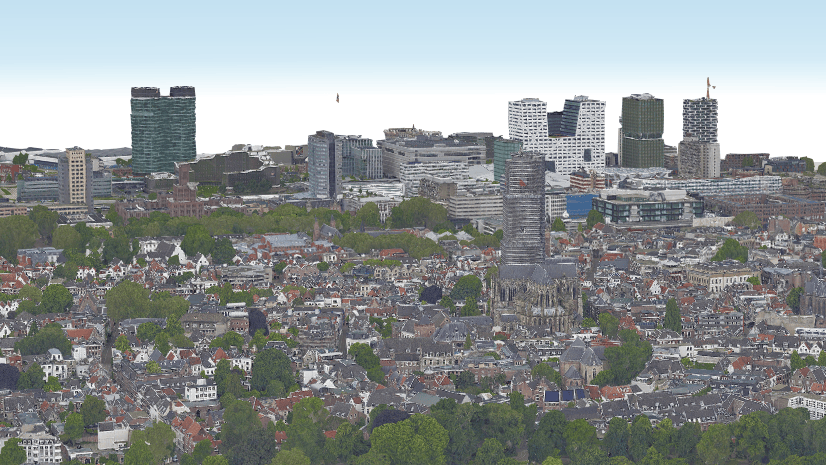
Want to mash up your own data with the 3D basemap? No problem! You can easily add a mask and add your own 3D content. In the example below I apply an exclude mask on the 3D buildings layer and then turn on a building scene layer to visualize the library with the surrounding buildings.

Relative to scene elevation mode
When features are in the 3D category of a local or global scene you can leverage a new elevation mode relative to scene. This mode is for features that know where they are compared to the scene. These features align to the ground and 3D objects such as extruded polygons or buildings. For example, let’s say you have points that you would like to display on top of the building. Previously, these points would have to have Z values on top of the building or a field specifying the height. Now with relative to scene, the points will render on top of 3D objects even if they do not have Z values.

Performance improvements
At each release we strive to improve performance across the geoprocessing tools that we own. At this release we have improved performance considerably for the create point scene layer content tool and clip tools. For clip we focused on improving performance when using 3D object or point cloud scene services as input. For the create 3D object scene layer content tool we have improved texture performance when using the Mobile or All texture optimization performance. Take a look at the table below for some sample datasets and comparisons across the releases.
| Tool | Dataset | ArcGIS Pro 3.1 | ArcGIS Pro 3.2 |
| Create 3D Object Scene Layer Content | City of Pasadena textured buildings | 14 mins | 7 mins |
| Create Point Scene Layer Content | Switzerland 80 million trees | 10 hours | 4 hours |
| Clip | Point cloud service with 35 million points | 45 mins | 3 mins |
Threshold angle
A new property on mesh symbols has been added to enhance the look of 3D object features. Every 3D object consists of multiple faces, including a back and front side. The threshold angle is the minimum angle between the face normals at which the stroke is drawn, and the default value is 35 degrees. By enabling the apply threshold angle to both sides of faces option, the stroke is applied to both sides of the face. This will enhance the look of complex shapes and in the case below you can see the better delineation of the domes with this new property.

Check out these new features and continue to add enhancement requests through technical support or ArcGIS ideas!

These 3D baemaps are great and the mask functionality too. But would it be possible to use a polygon feature layer as mask, instead of drawing? We have 800+ sites/buildings we would like to show in combination with the basemap, so that would mean a lot of drawing.