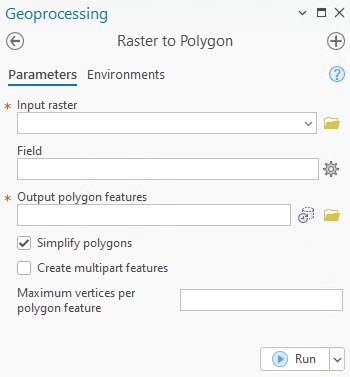
There are many options available on the Raster To Polygon geoprocessing tool to choose from when converting a raster to polygon features. ArcGIS Pro version 3.5 improved overall performance of this tool by at least 60 percent, and in some cases, it is 95 percent faster. However, often the raster is too large or has too many unique values to vectorize. This blog article will outline some of the techniques that can be used to vectorize the raster efficiently.

Figure: Raster to Polygon tool UI in ArcGIS Pro
First, decide which parameters to use before doing the conversion. If the raster has many unique values, for example, a digital elevation model (DEM), then leave the Create multipart features option unchecked. When it is checked, all the geometry is kept in memory until all the data is processed before writing it to disk, and this can cause the tool to fail when insufficient memory becomes available.
Convert large rasters
If the raster is very large or has many unique cells (greater than 2.1 billion), or a raster with one value and the cells have many NoData values around them, then conversion might be a problem because the output geometry could be too complex and have too many vertices.
In some cases, a warning message might appear: Writing a polygon with over 50 million vertices, consider subdividing the polygon. This is not an error; it is simply an informative message stating that one or more polygons have more than 50 million vertices. It is recommended that you subdivide extremely large features that could cause issues with drawing, analysis, editing, or performance. It is suggested that you rerun the tool and set the Maximum vertices per polygon feature parameter to a value less than 50 million.
You can resample the raster to a larger cell size using the Resample geoprocessing tool or generalize the raster to get rid of unnecessary details. You can also use the Simplify polygons option to reduce the amount of geometry. If all these options are unsuccessful, you can split the raster into smaller pieces using the Split Raster geoprocessing tool and then convert the smaller rasters to polygons. The merged output can be dissolved if it is not too complex and large. Using the Split Raster route is not recommended when using the Simplify polygons option because the polygons on the join lines might not line up as simplification was not performed on the complete polygon surrounding the join line.
Conclusion
The performance improvements also changed the order in which the vertices to be removed are treated when the Simplify polygons option is used. This means that the output may be slightly different from those created in previous versions, and this is expected.

Article Discussion: