ArcGIS Bathymetry, an extension to ArcGIS Pro, provides tools to manage large volumes of bathymetric data.
With the release of ArcGIS Pro 3.3, all the bathymetry tools in the Bathymetry toolbox are now accessible from the ArcGIS Pro toolbox. This means you are no longer required to manually add them to ArcGIS Pro from the Bathymetry product files.
With the move into the ArcGIS Pro toolbox, there are three new geoprocessing tools that can help you manage the Bathymetric Information System (BIS). The first of these tools is Add Point Data To BIS. Similar to the Add Point Cloud To BIS tool available at 3.2, the new tool accepts both point cloud and elevation point data and replaces the former tool previously available with the ArcGIS Bathymetry product files.

Learn more about the Add Point Data To BIS tool
Along with the more robust Add Point Data To BIS tool to help you maintain the health of your BIS, the Remove Data From BIS tool has been introduced to remove registered datasets from a catalog dataset in a BIS workspace. It is important to note that this tool does not delete or modify the datasets themselves; it only removes them from the BisCatalog catalog dataset and the BisBDI mosaic dataset, as well as any related proxy rasters.
Learn more about the Remove Data From BIS tool
The last new tool introduced at ArcGIS Pro 3.3 is the Analyze BIS tool. This tool can be used to perform a number of health checks on a BIS, including ensuring that the BIS structure is valid, and detecting any entries between the BisCatalog and BisBDI that do not match, as well as any broken links between the two. You can also run the tool to check for problems with proxy rasters in the BIS, and to remove any unused proxy rasters. Additional repair operations will be added to this tool in future releases.
Learn more about the Analyze BIS tool
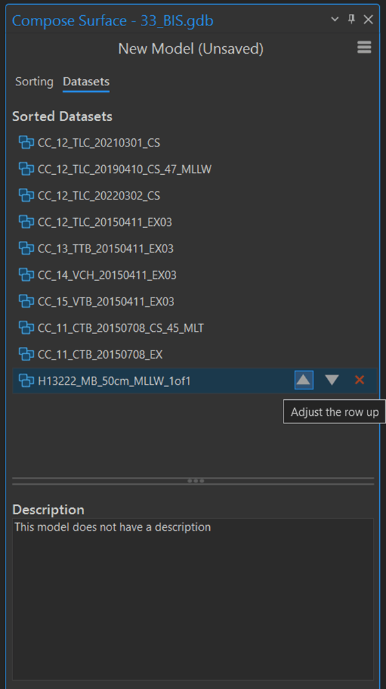
Along with these three new geoprocessing tools, the Compose Surface tool has also been enhanced with a new Datasets tab, where you can view sorted datasets in an ordered list according to the attribute rules configured on the Sorting tab.

You can use this list as a quick reference to see how datasets are ordered and make manual changes if there is a dataset you want to prioritize or move.
For more information on the latest in ArcGIS Bathymetry, visit the ArcGIS Bathymetry page or the What’s New documentation and post your questions in the ArcGIS Bathymetry board in Esri Community.

Commenting is not enabled for this article.