At the end of March, Remi Myers and Hussein Nasser conducted a live training seminar that covered several areas for the utility network – Get to know ArcGIS Utility Network Management extension.

Key concepts discussed during the seminar:
During these sessions, some great questions were fielded about the capabilities of a utility network. Many of the questions evolved around data models. The Utility Network Industry Configurations, and the data models they include, are a core element of a utility network. If available for your industry or resource, these should be considered as a starting point to jump start your work. See Introducing Utility Network Configurations blog to explore the available Utility Network Configurations, what is included, and the benefits of using them.
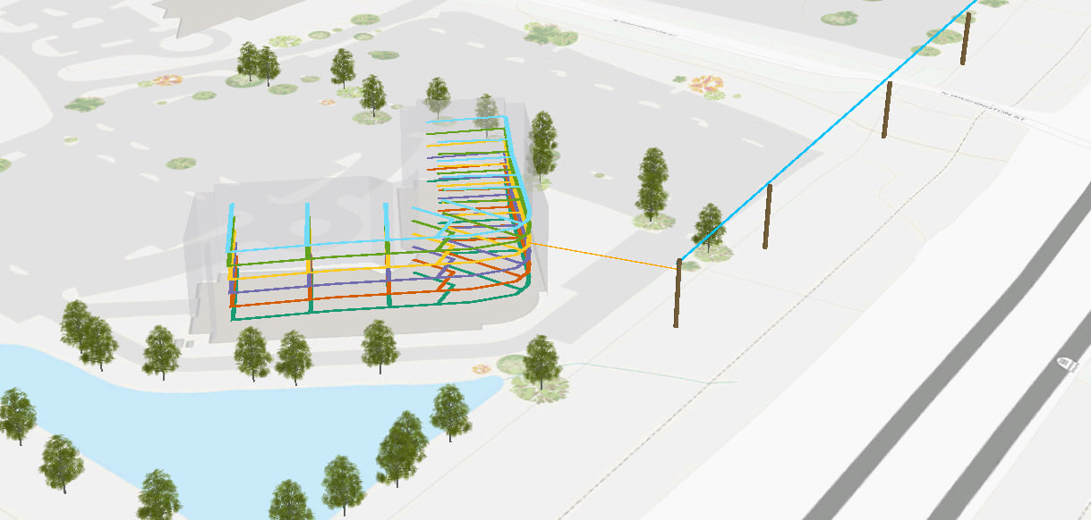
These Esri supplied configurations are intended to be extended to meet your needs, but are not the only way to get started. You can of course design your own custom data model if necessary. If a configuration is not available for your needs, the utility network can support many other network types. For example, streams have load flow characteristics, they participate with other flow paths to make up a regional watershed. Buildings have all the characteristics of utility service territories. They even have elements of water, electric, telecommunication and gas infrastructure as all part of a single operating system. Even though they are not ‘utilities’ many other systems have features that benefit from information management structure that is available in the context of the utility network.

The ArcGIS Utility Network Management extension was designed to manage linear assets across a service territory, to provide information about load capability, to determined connective and associated features, and to establish controllers through pumps, transformers, switches or valve devices to replicate the features and characteristics of a utility system. The rules that are packaged and deployed by Utility Network Industry Configurations can be customized to fit your data; simple or complex, all dependent upon your workflow and end users experience.
In fact, the term utility network is a little bit of a misnomer. While it was certainly designed to capture unique aspects and requirements from a utility GIS perspective, there are other opportunities to represent networks with similar characteristics. Indoor GIS solutions are particularly interesting; as mentioned above, buildings all have features that are easily adaptive to utility network models, but what about the systems within them? The utility network is designed to provide an operational perspective of linear systems with load, or load capability. Could logistical pipelines be created to represent the flow of assets or materials? Certainly, it could; relationships between distribution and customer centers can be established, and the volume of material can be modeled using customized validation and rules specific to your use case.
Power plants and industrial facilities could certainly be modeled within the utility network. Power plants could demonstrate logistical pipelines for fuel supply and the impact on load generated for the transmission system. Industrial faculties might be interested in tier one & tier two supplier relationships and how those companies impact production quotas.
During the seminar we had one listener ask about using the utility network for epidemiology and disease response. In the movie “Outbreak” GIS was used to model the spread of a highly contagious illness across the US. The utility network could certainly use its framework to represent linear flows of logistics and healthcare response. Additionally, incident and prevalence rates could be projected and modeled across your region of interest. The utility network could demonstrate patterns of health care support or even help you identify most responsive healthcare opportunities using the same tracing, containerization and association features used by our water, gas and electric customers.
Regardless of your business, the flexibility of the utility network information model, combined with the rigor of rule based validation and attribute propagation would be worthy of exploration and discovery. The utility network is holistic, just like any other GIS system. The utility network can support a wide range of networks and asset infrastructure as it’s an extendable framework. One that is designed for enhancement and development. In the upcoming months, it will be interesting to see the unique solutions that get rolled out by the Esri Solutions and partner teams.


Commenting is not enabled for this article.