Stormwater Utility Network Configuration Overview
This blog gives an overview of the Stormwater Utility Network Configuration and is part of a larger series of blogs of that take deep dives into popular ArcGIS Solutions. So if you are interested in stormwater or the utility network, read on!
What is an ArcGIS Solution?
ArcGIS Solutions are no-cost templates that configure ArcGIS to perform industry specific tasks and workflows. With well over 500,000 downloads and over 10 years of availability, many organizations have experienced how ArcGIS Solutions accelerate the benefits of mapping and GIS while simplifying implementation and reducing cost.
ArcGIS Solution templates can be freely deployed on your ArcGIS licensing and are fully supported at no additional cost through an organization’s Esri Maintenance Program. They are designed and documented for a do it yourself (DIY) style of implementation although many organizations choose to have Esri Partners or Esri Professional Services perform their implementation.
Currently ArcGIS Solutions are available for 8 industries – local government, state government, emergency management, defense, water utilities, electric utilities, gas utilities and telecommunications. Soon we will add templates for the commercial industry to the ArcGIS Solutions collection.
Across the 450+ ArcGIS Solutions available today you’ll find a mix of productivity tools, app configurations and workflows. Some ArcGIS Solutions are designed to support individuals performing a task, while others are designed to enable organizations to overcome big challenges or achieve strategic initiatives.
What does the Stormwater Utility Network Configuration do?
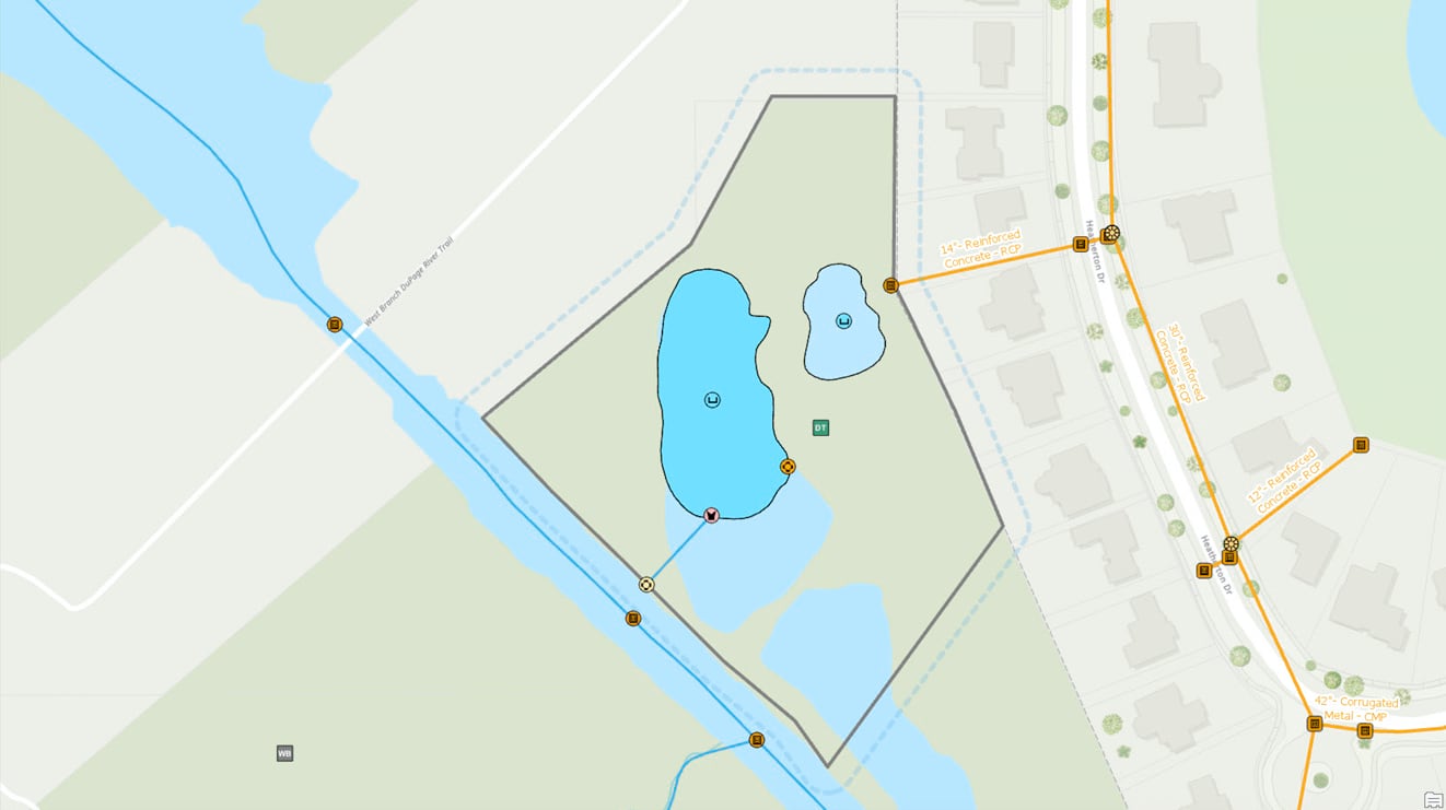
As the name implies, the Stormwater Utility Network Configuration does the work of configuring a utility network to behave like a stormwater system – plus a whole lot more.
The Stormwater Utility Network Configuration includes:
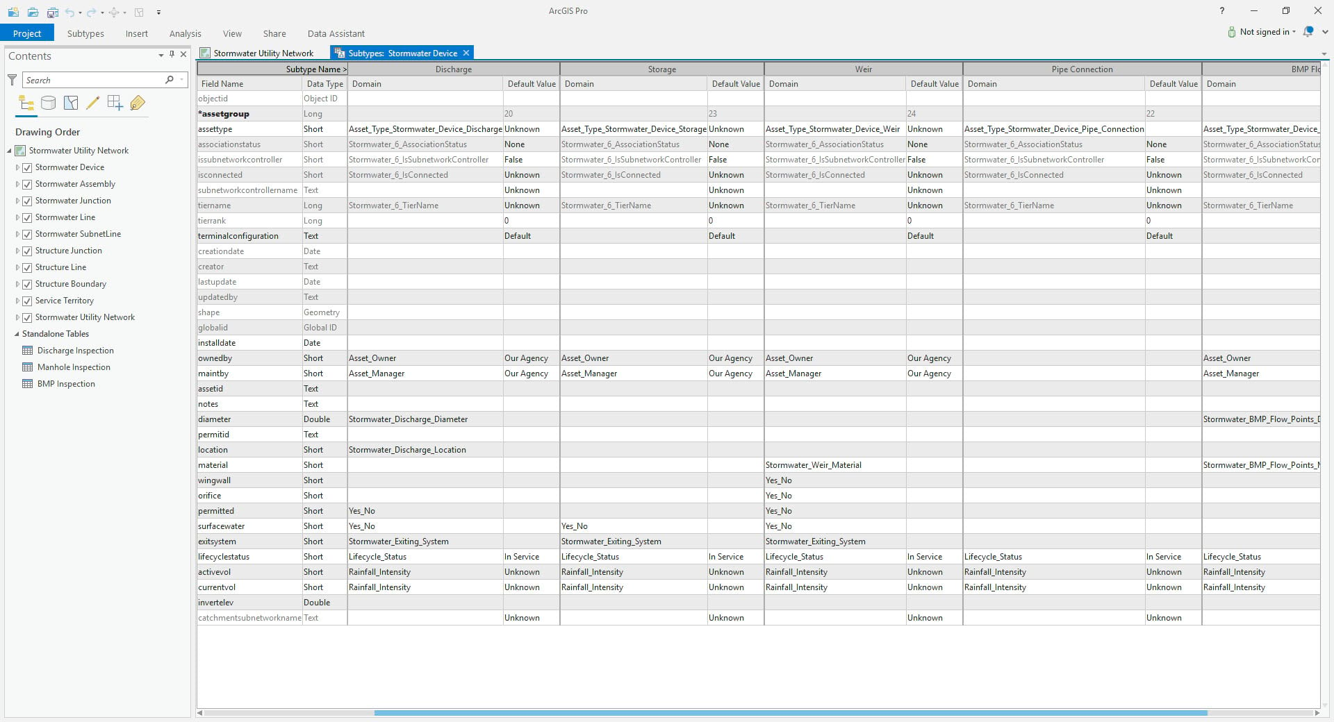
- A utility network schema for common stormwater system assets, including both gray (manmade) and green (natural) infrastructure
- Rules that define typical stormwater system behavior for the included assets
- ArcGIS Pro Projects to configure and publish a utility network service
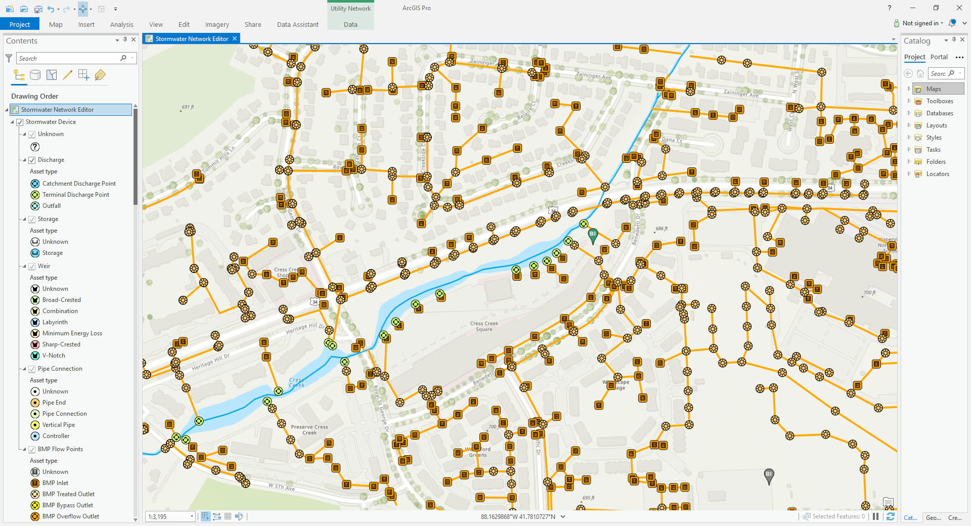
- Maps that are preconfigured to use the published stormwater network services
- Sample data
- Instructions
It is important to understand the Stormwater Utility Network Configuration is a starting place for deploying a utility network for stormwater. You should modify the configuration to fit how your stormwater system physically exists and functions.
It’s also important to know that you are not required to use the Stormwater Utility Network Configuration if you want to represent a stormwater system as a utility network. If the schema and rules included in the Stormwater Utility Network Configuration are very different from how your system exists and operates in the real world, you may be better served by building your own custom data model.
What are the benefits of using the Stormwater Utility Network Configuration?
Rather than building schema and rules from the ground up, you can save a significant amount of time and cost by starting your implementation with the Stormwater Utility Network Configuration. Then further refine the schema and rules to fit your system.
With the Stormwater Utility Network Configuration, you are leveraging the research and data modeling Esri has done on how to apply the advanced capabilities of the utility network to stormwater systems. Kudos to Esri Business Partner 2nd Nature, who has supported our data modeling efforts with their stormwater expertise.
The included ArcGIS Pro projects will save you the work of having to build a Pro map to publish the network service and then having to build maps to work with the published network services. The included maps are preconfigured with symbols, labels, and popups to make it easy for users to interact with the network.
The documentation guides you through the process of deploying the configuration. Since the Stormwater Utility Network Configuration is fully supported if you have any issues with your deployment Esri Support can assist you.
Frequently Asked Questions about the Stormwater Utility Network Configuration
Q: Where is Esri’s stormwater data model for the utility network?
A: It is in the Stormwater Utility Network Configuration. It’s the combination of the utility network schema and the rules. Refer to the data model section of the help for more information.
Q: What do I do if the StormwaterUtility Network Configuration doesn’t include all the gray and green assets in my stormwater system and/or all the attributes I need to track?
A: You should extend the Stormwater Utility Network Configuration to represent your system and capture the attributes you require. Remember, the Stormwater Utility Network Configuration is a starting place and is not intended to be implemented exactly as is.
Q: Do I have to use the Stormwater Utility Network Configuration if I want to represent a stormwater system in the utility network?
A: No. You can build your own data model. You may find it useful to first experience the sample data included with the Stormwater Utility Network Configuration before building your own data model to understand ways to set up stormwater behaviors with the utility network.
Q: Will the Stormwater Utility Network Configuration change?
A: Yes. The Stormwater Utility Network Configuration will continue to evolve along with the capabilities of the utility network and the needs of organizations that manage stormwater systems. Remember, the Stormwater Utility Network Configuration is intended to be a starting place, your implementation will naturally branch away from it over time. You should not feel compelled to upgrade your schema to match new releases of the Configuration unless there is a business reason to do so.
Q: Does the Stormwater Utility Network Configuration support MS4 permitting?
A: The Stormwater Utility Network Configuration was designed to include typical assets and attributes necessary for MS4 permitting. As MS4 permitting has a degree of data and process variation from state to state you will need to add any additional state or EPA required schema and create your own maps, reports, apps, or dashboards to support your specific to your permit needs.
Q: Is the Stormwater Utility Network Configuration designed just to model stormwater systems in the United States or is it designed for international use?
A: The Stormwater Utility Network Data Model is intended to support stormwater systems internationally. The more feedback we receive from international organizations that manage stormwater systems, the more we will enhance the configuration to better support the global stormwater community.
Q: How do I provide feedback or enhancement requests for the Stormwater Utility Network Configuration?
A: Feedback can be provided via GeoNet. Enhancement Requests can be logged via Esri Technical Support.

Commenting is not enabled for this article.