ArcGIS StoryMaps is the professional tool for harnessing the power of maps to communicate your work using place-based storytelling. The easy-to-use builder enables you to combine maps, 3D scenes, embedded content, multimedia, and more to create an interactive narrative that can inspire interest — and action — from your readers.
Each month, our team uses community feedback to help inform new capabilities that can enhance your storytelling adventures. Check out what’s new this month!
Quick links
- ArcGIS Online recycle bin
- Customize pre-set builder themes
- Align Minimal cover text
- Embed ArcGIS apps in sidecar
- Undo/redo in briefings
- Time-enabled 3D scenes
- And more…
ArcGIS Online recycle bin
To delete or to recycle — the choice is now yours. When deleting ArcGIS StoryMaps outputs (stories, briefings, collections, and themes) from your content pages, the new default will be to relocate those deleted items to the ArcGIS Online recycle bin, where they can be recovered within 14 days. Know for sure that you’ll never need the item again? When you click to delete any item, you have the option to override that recycle bin default and permanently delete the item.
You can access your recycle bin items directly from ArcGIS StoryMaps by going to the list of Quick links found on your ArcGIS StoryMaps content pages — find the ArcGIS recycle link at the bottom of the list. This link will bring you to your ArcGIS Online content page, where you can opt to restore items or permanently delete them.
Customize pre-set builder themes
We’ve heard this request from many of you — and we’re just as excited about it! The ArcGIS StoryMaps builder offers six options for pre-set themes designed by our team, covering a variety of topics and moods. These themes are great for those new to ArcGIS StoryMaps, who don’t have the time to design a theme from scratch, or who want to align with their organization’s branding. But often, a tweak here or there to one of these pre-set themes is needed to fully align with your story design.
You can now start with any one of these six options in the theme builder to make those necessary changes! After clicking to add a new theme, select your desired starting theme from the left panel to reveal the theme editing controls from which you can make your customizations. Looking for that “start from scratch” theme you’re accustomed to? Summit is the former default that was used as the base for new custom themes, so select this option for a neutral starting place.
Check out this collection of stories with great themes for inspiration to design your own!
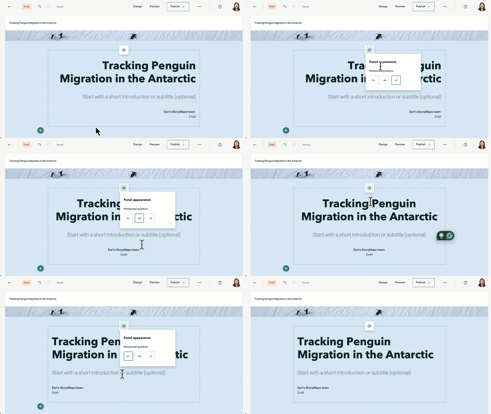
Align Minimal cover text
In February 2024, we expanded the design options for the Full and Side-by-side cover layouts — and it’s time for Minimal to have its moment! You now have the choice of three horizontal text alignment options to complement your story design.

Learn more about starting your story with bang with these Nine steps to great storytelling.
Embed ArcGIS apps in sidecar
Have an ArcGIS Survey123 form or Dashboard to supplement your media? You can now embed these interactive apps live alongside your media in the narrative panel of sidecar slides to gather information from your readers or share further context or data about your subject.
With great power comes great responsibility: Available for all three sidecar layouts, you will want to consider your audience and pay attention to the resulting user experience, especially when embedding dashboards. You will likely need to expand your narrative panel width to accommodate most dashboards, and even then, more complex dashboards will be challenging to interact with. It’s essential to assess your reader’s experience to decide whether it’s best displayed live or as a card (which you can still opt to do using the embed block options).
Integrating ArcGIS Apps into your stories can add a new dimension to the narrative and provides functionality for collecting and visualizing data. Check out this collection of Stories with apps to get inspired!

Undo/Redo in briefings
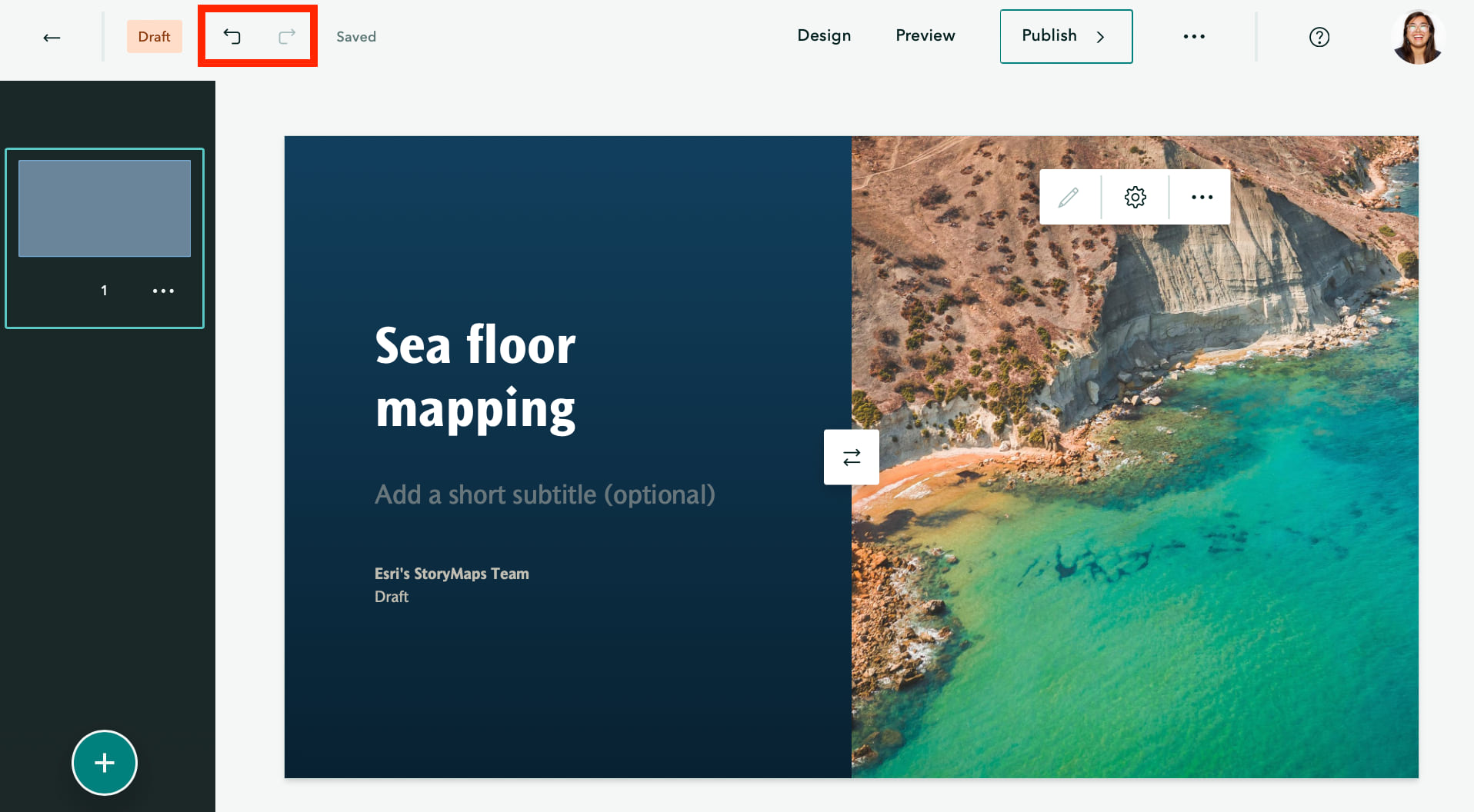
It’s been 580 days since our lives changed when Undo/Redo was added to the ArcGIS StoryMaps builder. And now we can all calmly say “oops” in the briefings builder, too! Whether you deleted something by mistake or need to change your mind yet again, you can find Undo and Redo buttons at the top of the builder.

Undo and redo are currently in beta. Please let us know on the Esri Community if you find any issues or have feedback.
Time-enabled 3D scenes
3D scenes are cool. Time animation is cool. So, it only made sense to join forces. Many stories have been enhanced by visualizing data across temporal scales in web maps using time extent bookmarks in ArcGIS Map Viewer — and now this capability is expanded to 3D scenes via time extent slides in ArcGIS Scene Viewer.
Adding a time-animated scene to your story? After adding the scene, toggle on Time animation in the Adjust map appearance panel to reveal the time animation widget at the bottom of your scene.
Check out this collection of stories that are Great examples: 3D mapping to get inspired!
And more…
A few other updates to the ArcGIS StoryMaps builder and related tools include:
- Apply Keep pop-up open to map image layers and layers inside layer groups
- Updated mapping capabilities with latest versions of ArcGIS Map Viewer and ArcGIS API for JavaScript
- Updated mapping capabilities with latest version of ArcGIS Online
Check out the release notes for more detail about other small changes and fixes released this month.
Meet us at Esri User Conference 2024
Attending Esri User Conference 2024? Join our ArcGIS StoryMaps sessions or meet the team at our Esri UC Expo booth!
ArcGIS StoryMaps: An Overview
Tuesday, Jul 16 | 2:30 – 3:30 PM PDT
Thursday, Jul 18 | 8:30 – 9:30 AM PDT
ArcGIS StoryMaps: What’s New and the Road Ahead
Wednesday, Jul 17 | 8:30 – 9:30 AM PDT
Thursday, Jul 18 | 1:00 – 2:00 PM PDT
ArcGIS StoryMaps: Dynamic Briefings Anywhere, Anytime, Even Offline
Wednesday, Jul 17 | 4:00 – 4:45 PM PDT
Storytelling with Maps Fireside Chats at Esri UC 2024
Join some of your favorite experts at the Storytelling with Maps Fireside Chats for open discussions on innovative ways to use place-based storytelling for sharing work and inspiring action. From science communication to 3D visualizations to local perspectives, Fireside Chats is your opportunity to hear from — and speak to — experienced storytellers, researchers, and cartographers. Don’t miss this chance to learn more about how you can transform your communication needs by telling stories with maps.
Location: Sails Pavilion
Discovering the story in science communication
Dawn Wright, Esri and John Nelson, Esri
Tuesday, Jul 16 | 11:30 – 12:30 PM PDT
Adding depth to your stories with 3D
Katie Grillo, City of Cambridge and Craig McCabe, Esri
Wednesday, Jul 17 | 11:30 – 12:30 PM PDT
Connecting local stories with global communities
Natalie Cox, IUCN and Brian Hettler, Amazon Conservation Team
Thursday, Jul 18 | 11:30 – 12:30 PM PDT
Thank you to Ashley Du for her contributions to this post.
All Adobe Stock images are © 2024 Adobe Stock. All rights reserved.
Article Discussion: