We’re very excited to connect with users at the 2023 Esri Developer Summit next week in Palm Springs, CA! Members of Esri’s product and development teams will be available to provide demonstrations, answer questions, and help you explore the broad range of spatial analysis and data science capabilities in ArcGIS.
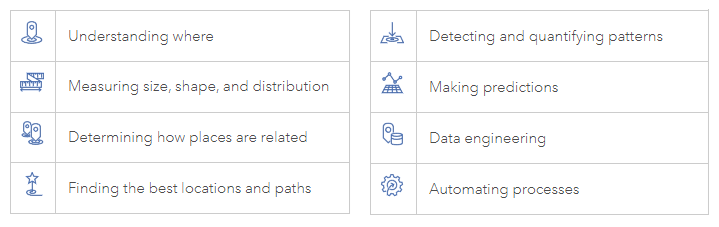
Regardless of the industry or problem you’re trying to solve, in many cases there’s a core set of questions that you’re usually asking when working with spatial data. This includes understanding where locations, incidents, or patterns are; as well as measuring the size, shape, and distribution of geographic features or sets of features. Then there’s determining how places are related to each other (closest, within, etc), as well as finding the best locations and paths such as which areas satisfy criteria or which is the fastest route. And going further – detecting and quantifying patterns such as hot spots and change in patterns over time, and finally making predictions so that issues can be anticipated and possibly mitigated before they occur. These core questions are all part of the language of spatial analysis.
Check out the below guide for an overview of spatial analysis-related technical sessions and presentations at this year’s DevSummit, with indicators for which of the above spatial analysis questions and processes the session is covering. The guide also includes whether the session discusses other important concepts that are often part of spatial analysis workflows, such as data engineering and process automation (scripting, job scheduling, etc).
If you haven’t registered yet, check out your registration options here. Follow us on Twitter for the latest updates. Hope to see you there!
Legend: Spatial Analysis Concepts
All times PST. All locations reference the Palm Springs Convention Center and the Renaissance Marriott.
Tuesday, March 7
| Session Title | Time | Location | Type | Spatial Analysis Concepts |
|---|---|---|---|---|
| Spatial Data Science in ArcGIS | 01:00 PM – 02:00 PM | Primrose B | Technical Session | general |
| Spatial Data Science with ArcGIS Notebooks | 02:30 PM – 03:30 PM | Primrose B | Technical Session | general |
| ArcGIS Velocity: An Introduction | 04:00 PM – 05:00 PM | Primrose B | Technical Session |   |
| Spatial Analysis using ArcGIS API for Python | 05:30 PM – 06:30 PM | Smoketree A-E | Technical Session | |
| ArcGIS Insights: Cloud Analytics With Big Data | 05:30 PM – 06:30 PM | Mesquite C | Technical Session |  |
Wednesday, March 8
| Session Title | Time | Location | Type | Spatial Analysis Concepts |
|---|---|---|---|---|
| Data Frames | 10:30 AM – 11:30 AM | Pasadena/Sierra/Ventura | Technical Session | |
| Building Web Applications and Notebooks with ArcGIS Knowledge | 10:30 AM – 11:30 AM | Mesquite C | Technical Session |  |
| Data Visualization for Spatial Analysis with ArcPy Charts | 10:30 AM – 11:00 AM | Demo Theater 1 Oasis 1 & 2 | Demo Theater |  |
| Find What You Are Looking For: Optimizing Search and Filtering in Apps | 10:30 AM – 11:00 AM | Demo Theater 2 Oasis 1 & 2 | Demo Theater | |
| Spatial Data Science Explained: Foundations and Innovations in Regression | 11:15 AM – 11:45 AM | Demo Theater 1 Oasis 1 & 2 | Demo Theater |  |
| Working with Spatially Enabled Dataframes (SeDF) | 01:00 PM – 01:30 PM | Demo Theater 3 Mesquite D-E | Demo Theater | |
| Python Toolboxes for Developers and Novice Users | 01:00 PM – 01:30 PM | Mesquite B | User Presentation | |
| Isolation Tracing as a Service: A Custom ArcPy Solution for Water Networks | 01:00 PM – 01:30 PM | Mesquite C | User Presentation | |
| Developing a Hydrological Modeling Utility Tool Using ArcGIS Pro SDK | 01:45 PM – 02:15 PM | Mesquite C | User Presentation |  |
| Analyzing Multidimensional Features using Python | 02:30 PM – 03:00 PM | Demo Theater 1 Oasis 1 & 2 | Demo Theater | |
| Working with Time Data in ArcGIS Online | 03:15 PM – 03:45 PM | Demo Theater 3 Mesquite D-E | Demo Theater | |
| Leverage the Power of Arrow in ArcGIS | 03:15 PM – 03:45 PM | Demo Theater 1 Oasis 1 & 2 | Demo Theater | |
| ArcPy: Working with Raster Data | 04:00 PM – 05:00 PM | San Jacinto | Technical Session | |
| Automating the Extraction of Information from Imagery Using Deep Learning | 04:00 PM – 05:00 PM | Primrose B | Technical Session | |
| Enabling Customer Analytics with ArcGIS Enterprise and ArcGIS for Javascript API | 04:45 PM – 05:15 PM | Mesquite C | User Presentation | |
| GeoAnalytics Engine: Custom Analysis in Your Cloud Environment | 04:45 PM – 05:15 PM | Demo Theater 1 Oasis 1 & 2 | Demo Theater |  |
| Harnessing the Power of R in ArcGIS with R-ArcGIS Bridge | 05:30 PM – 06:30 PM | San Jacinto | Technical Session | |
| ArcGIS Maps SDK for JavaScript: Real-Time Data Visualization and Analytics | 05:30 PM – 06:30 PM | Pasadena/Sierra/Ventura | Technical Session | |
| Advanced Analysis of Satellite Imagery Using Python | 05:30 PM – 06:30 PM | Primrose B | Technical Session | |
Thursday, March 9
| Session Title | Time | Location | Type | Spatial Analysis Concepts |
|---|---|---|---|---|
| Working with Geometries in ArcGIS API for Python | 10:30 PM – 11:00 PM | Demo Theater 1 Oasis 1 & 2 | Demo Theater | |
| Creating Geoprocessing Tools | 01:00 PM – 02:00 PM | Primrose A | Technical Session | |
| GeoAnalytics Engine: Big Data and Spatial Analysis | 02:30 PM – 03:30 PM | San Jacinto | Technical Session | |
| Geospatial Deep Learning with ArcGIS | 02:30 PM – 03:30 PM | Primrose C-D | Technical Session | |
| ArcGIS Pro: The Road Ahead | 02:30 PM – 03:30 PM | Pasadena/Sierra/Ventura | Technical Session | general |
| Spatially-Enabled DataFrames v GeoPandas: Comparing Python Geospatial Frameworks | 03:15 PM – 03:45 PM | Comparing Python Geospatial Frameworks – Mesquite C | User Presentation | |
| ArcGIS Velocity: Stateful Real-Time Analytics with Arcade | 03:15 PM – 03:45 PM | Demo Theater 1 Oasis 1 & 2 | Demo Theater | |
| ArcGIS Insights: Scripting with Python and R | 04:00 PM – 05:00 PM | Mojave Learning Center | Technical Session | |
| Automating the Analysis of Road Construction Projects with ArcGIS and Python | 04:00 PM – 04:30 PM | Mesquite C | User Presentation | |
| Data Engineering in ArcGIS: Exploring, Transforming, and Integrating Data | 05:30 PM – 06:30 PM | Primrose C-D | Technical Session | |
Friday, March 10
| Session Title | Time | Location | Type | Spatial Analysis Concepts |
|---|---|---|---|---|
| ArcGIS Business Analyst: Data Enrichment at Scale | 08:30 AM – 09:30 AM | Mesquite B | Technical Session | |
| Distributing Geoprocessing and Python Functionality | 08:30 AM – 09:30 AM | Primrose B | Technical Session | |
| ArcGIS Pro: Level Up with Python | 10:00 AM – 11:00 AM | Primrose A | Technical Session | |
| Analyzing Multidimensional Scientific Data using Python | 10:00 AM – 11:00 AM | Mesquite B | Technical Session | |
| Leveraging Real-Time Capabilities in Your Apps | 10:00 AM – 11:00 AM | Smoketree A-E | Technical Session | |


Article Discussion: