Why would water operators care about geographic information system (GIS) technology? To answer this, let’s talk about the roles and responsibilities of water operators. Primarily, they are responsible for delivering safe drinking water on time and on budget. What does this really mean when it comes down to their daily work?
The most obvious answer is system operation.
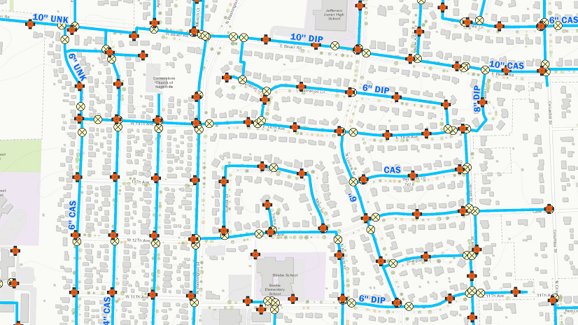
There are many aspects to system operation. One is knowing where your infrastructure is. Having a complete map of your assets is essential in enabling workflow efficiency.
In addition to location, system operation also consists of the following:
- Record keeping of system changes, meter readings, maintenance activities, inspections, etc.
- Preparation/Execution of a maintenance plan
- Creation of standard operating procedures
GIS is an amazing system of record. It provides an easy-to-use platform that manages data collection, editing, and sharing. It excels as an authoritative data repository. In addition, data in a GIS can be used for analysis, which supports the development and execution of a maintenance plan. A GIS delivers everything you need to meet data and maintenance goals and provides insight that can strengthen your standard operating procedures.
An important responsibility for water operators is regulatory compliance.
All water service providers are regulated at the federal level by the US Environmental Protection Agency and at the state level by various state health and environmental agencies.
One example of regulatory compliance is conducting water sampling to ensure water is suitable for its intended use. Storing sampling locations in ArcGIS provides a visual representation—a map—of these locations throughout the service area. You can then use this information, together with routing tools, to determine the most efficient routes for visiting these locations. ArcGIS allows you to do the following:
- Maintain a record of sampling locations
- Manage sampling routes and collection of samples
- Provide data to regulators
Another example of compliance is obtaining a National Pollutant Discharge Elimination System (NPDES) program permit, created by the Clean Water Act. This regulates point sources that discharge pollutants into the waters of the United States. Did you know that Esri customers are using Survey123 for ArcGIS to support data gathering and reporting for their NPDES permits?
Communication is vital to the success of a water operation.
Communicating with office staff, field staff, and the management team isn’t always easy. The needs of stakeholders can vary. ArcGIS supports your need to:
- Report work status to supervisors and managers
- Provide a summary of system performance to managers and board members
- Share your story with customers
- Engage Cross-functional teams
Having information about system assets, including as-built drawings, photos, and videos, can save field and office staff a lot of time. Supervisors and managers need to know if the work being completed is on schedule to meet their goals. Managers and board members often require system performance updates. In addition, it is often necessary to communicate with cross-functional teams like engineers.
ArcGIS includes a suite of applications that support communication among all stakeholders.
Dashboards, for example, support communication. These can be used to share real-time work being done in the field and display sensor readings, service requests, and more. Each dashboard can be configured to show what is important to each stakeholder. The results of analytics can be shared within a dashboard as charts, graphs, and maps, making communications clear and concise. In addition, easy-to-use tools like Esri’s Web AppBuilder for ArcGIS provide a way to create applications that are configured specifically for your needs within operations as well as across your organization.
Story maps can also be used to engage stakeholders by providing information paired with beautiful images, maps, and even video.
This blog is certainly not all-inclusive, but I hope it has provided some insight into the diversity of ArcGIS and how it can be a multifaceted tool that supports the work that you do. Having good data that is available to everyone who needs it and implementing easy-to-use applications can improve efficiencies across multiple teams—saving you time and money.
To learn how to optimize your field operations check out Esri’s Mobile Workforce Solution. If you have questions or need help, Esri’s water team is always willing to support you.
Christa Campbell
Industry Specialist—Global Water Practice
Implementing ArcGIS for the operations team has resulted in 39% more work being completed with the same budget

Commenting is not enabled for this article.