We’re pleased to announce that ArcGIS Runtime 100.8 is now available!
It’s been four months since our last release, and 100.8, also known as Update 8, continues to build on functionality for the Utilities, Defense, and Public Safety sectors, but also delivers key platform enhancements across the board. This release includes new network tracing options, support for online layers in mobile packages, and improvements to dynamic rendering of images and symbols. Update 8 also shores up some fundamental capabilities such as identify on raster layers and support for new locators in 32-bit environments. Here’s a closer look:
Utility network
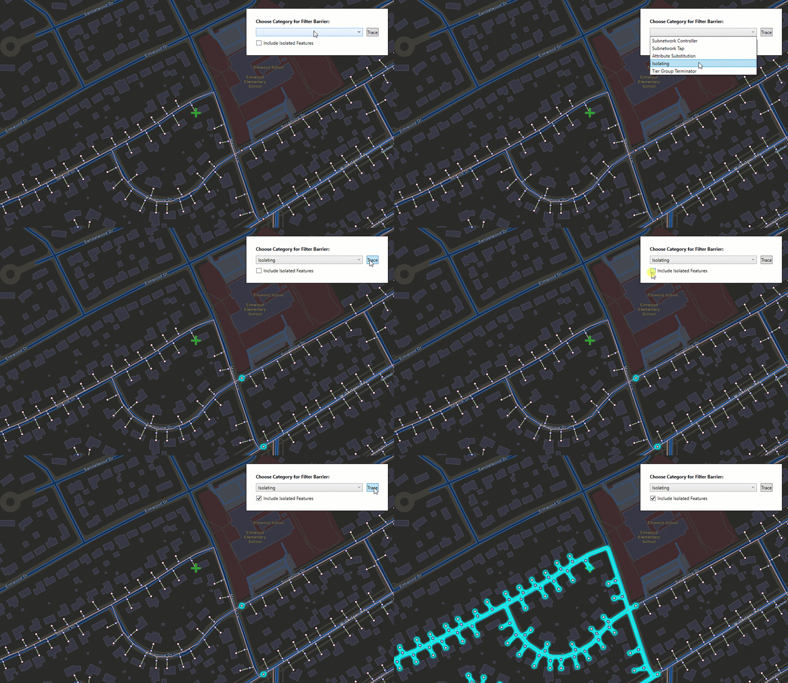
We’ve added a new utility network trace type: isolation trace. An isolation trace is used to determine the minimum set of operable features that can be turned off to isolate a network resource (and also, of course, anything downstream from that resource). For instance, when a leak occurs on a gas network, an isolation trace would identify which valves should be closed to prevent any flow of gas to the location of the leak.

Trace filters are a new configuration option for utility networks that restrict the results returned by a trace while still allowing the trace to traverse to the source. These filters allow utility managers to examine the nearest upstream protective devices.
You can now visualize network associations on a map using geometry that represents structural attachment and connectivity associations.
We also introduced a change to licensing use of utility networks. You can now view utility network properties and associations without an ArcGIS Runtime Utility Network extension. With 100.8, a Utility Network extension is only required for trace operations.
Image overlays
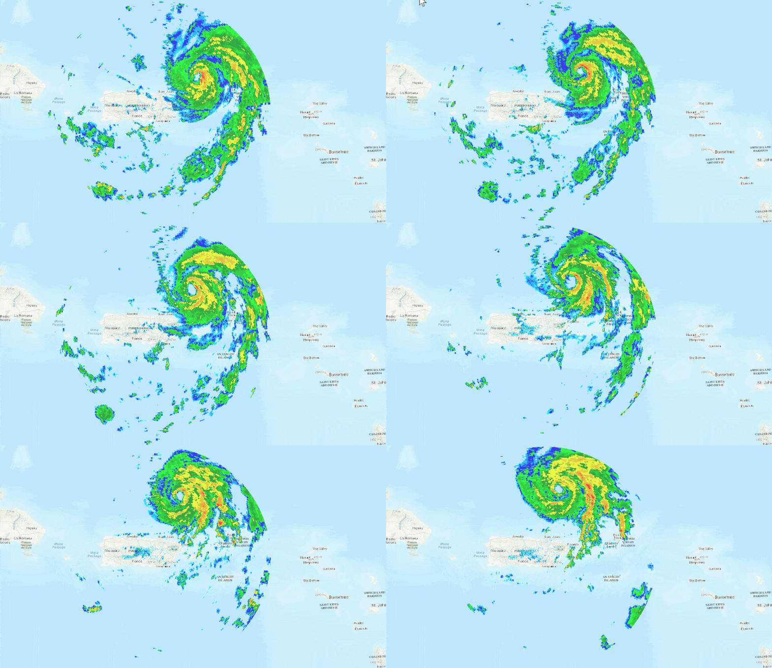
Image overlays are a new overlay type which can be used to render frequently changing images in a scene view. For example, rendering real-time data, such as precipitation, where each static image represents a single frame from a radar sensor. As they’re optimized for quick display, image overlays do not support the rich processing and rendering capabilities of a raster layer, which still provides the best option for workflows that require static image rendering, analysis, and persistence.

Online layers in mobile map and scene packages
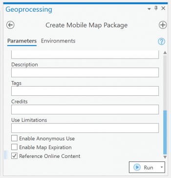
We now support online services in mobile map and scene packages (.mmpk and .mspk). With ArcGIS Pro 2.6 (due to be released this summer), users will be able to create mobile packages that have a mix of local and online service content, such as weather or traffic. If network connectivity is available, your app users can utilize online services, but if there is no connection, users can keep working with their local content. Granted, as a developer you’ve been able to build native apps and experiences that include both local and online content already – but it was a developer only option. Local content may have come from a mobile package while online content was added separately. This enhancement provides a formal workflow for defining and delivering local and online content in the same map or scene, in a single package – reducing the need for app logic to combine local and online sources.

Symbology
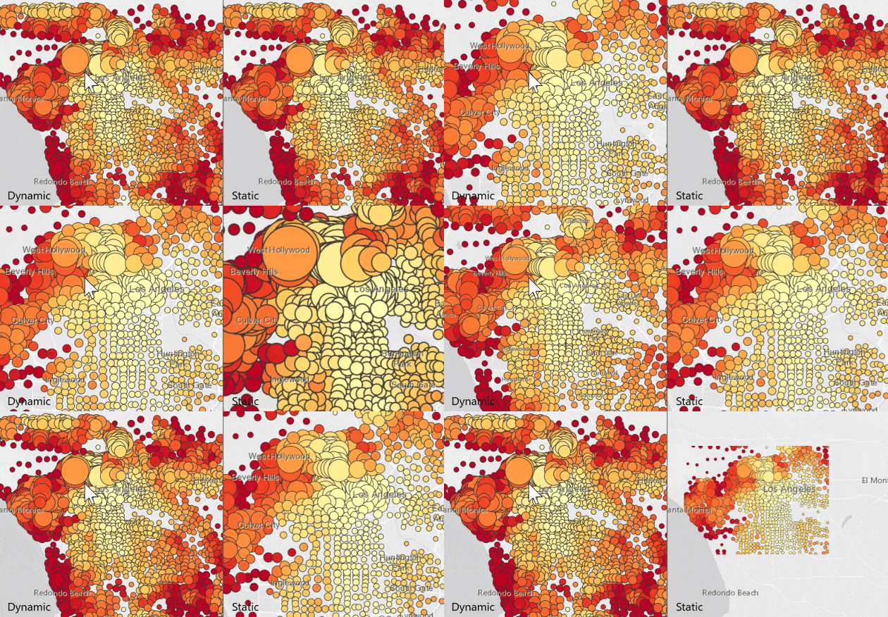
Prior to 100.8, point features rendered using marker symbols defined by visual variables and/or reference scale were displayed using Runtime’s static rendering mode. While this enabled symbols to be rendered accurately, the static nature of the display (eg update only after navigation is complete) was less polished. With 100.8 these same marker symbols can take advantage of Runtime’s dynamic rendering mode for a GPU driven, responsive display experience. While this enhancement only applies to marker symbols for point features in a map, we plan to continue to optimize the similar symbology display options for other types, styles, and experiences going forward.

Features and graphics can now be placed relative to objects in a scene, such as an elevation surface, buildings in a scene layer, integrated mesh layers, and extruded polygons. Note that some objects do not affect relative to scene placement, such as extruded points or lines, KML layers, or model symbols.
Text rendering in scene views has been greatly improved with a signed distance field (SDF) algorithm. In addition to being more efficient, and therefore using fewer resources, text in a scene view now supports background, outline, and halo colors, rotation relative to the screen or local north, strikethrough, underline, and better support for languages with connected characters (such as Bengali, Thai, or Arabic).
Identify and popups
We now offer the ability to perform identify operations on raster layers to obtain individual raster cell (or pixel) values. Identify is supported for raster layers referencing ArcGIS Image Services or local raster files. The raster cell values can be displayed in popups created by the developer or from popups defined in web maps and web scenes authored in ArcGIS Online or ArcGIS Enterprise.
Use of Arcade expressions in popups has been enhanced to support featuresets and asynchronous evaluation. Featuresets allow you to define subsets of data within a feature layer or subsets based on calculations between layers within a map. For example, an Arcade expression can be defined such that results in a popup can show all features in one layer that intersect a selected feature in another layer, such as a count of all trees in a county.
Routing and navigation
The Directions engine in ArcGIS Runtime has been upgraded to match what is used in the rest of the ArcGIS platform. It is backwards compatible with existing transportation network datasets, requires no API changes, and provides results that are consistent with other ArcGIS products such as ArcGIS Pro, Enterprise, and Online. Furthermore, the performance of generating routes and turn-by-turn driving directions has increased by an average of 50% on desktop machines and 30% on mobile devices.
A new simulated location data source allows you to mock incoming GPS positions using a polyline. This can be used to test or demonstrate functionality that requires a device to be moving, such as navigating a route, when the device is not in motion. A location change event is raised for each point in the simulated data source and locations in the collection are visited in order, allowing you to simulate travel along a path at a defined rate of speed.
Platform improvements and changes
New locators were introduced with ArcGIS Pro 2.3 via the Create Locator tool and supported in ArcGIS Runtime 100.5. These locators consist of a *.loc and *.loz file – they’re smaller, faster, easier to maintain, and offer consistency across the ArcGIS platform. With 100.8 we now support use of these new locators in 32-bit environments, notably on Android and Windows platforms. With that in mind, classic geocode locators (only *.loc), created in ArcGIS Pro via the Create Address Locator tool, will not be supported after ArcGIS Runtime version 100.9 (scheduled to be released in August 2020). Note, this only pertains to use of local locators – there is no change to Runtime support for ArcGIS geocode services.
With version 100.8 of the ArcGIS Runtime SDK for iOS we introduced support for Metal, a new rendering architecture optimized for Apple platforms. Comprehensive testing has shown improved performance and memory usage. As support for OpenGL ES will no longer be included, any development or testing that uses the iOS Simulator must use a simulator that supports Metal to view a map view or scene view. In general this means that to use 100.8 with an iOS Simulator you must meet the following minimum requirements:
- Develop on macOS Catalina (10.15)
- Use XCode 11
- Simulate iOS 13
For other ArcGIS Runtime SDKs that support iOS and/or macOS (Qt, .NET, Java) we plan to deliver support for Metal in future releases.
For Runtime developers that use ArcGIS Runtime Local Server, version 100.8 will be last release to support ArcGIS Desktop 10.x packages (created in ArcMap). The next ArcGIS Runtime Local Server version will require packages to be created with ArcGIS Pro. Note, ArcGIS Runtime Local Server can be used with newer versions of the ArcGIS Runtime SDKs for .NET, Java, and Qt. ArcGIS Runtime Local Server 100.8 is scheduled to be released later this month.
In additional to all of the above, we’ve also fixed multiple bugs and continue to make improvements in performance and memory usage. For more details, see the release notes for Android, Qt, .NET, Java, and iOS.
We’re excited about how 100.8 continues to build on support for the Utilities, Defense, and Public Safety sectors and strengthens support for ArcGIS platform capabilities. We can’t wait to see how this enhances your app experiences!
Download and get started
To get 100.8, go to the ArcGIS for Developers web site, browse the ArcGIS Runtime SDK page of your choice and download the SDK. You can also reference through NuGet, Gradle, or CocoaPods. If you’re new to developing with ArcGIS Runtime and don’t have an ArcGIS Developer subscription, simply sign up for a free account and you’ll be able to access everything you need to develop your app.


Commenting is no longer enabled for this article