ArcGIS GeoEvent Server allows organizations to ingest, visualize, analyze, and act on data from sensors and asset tracks. Whether you’re tracking moving assets or monitoring stationary sensors, you can tap into, analyze, and display real-time and the Internet of Things (IoT) data on your maps using GeoEvent Server.
ArcGIS GeoEvent Server 11.1 includes new features, improved usability and performance, and stability enhancements throughout the product. Some highlights in the 11.1 release include the following:
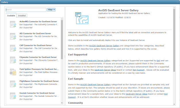
- The biggest news, a new add-on manager in ArcGIS GeoEvent Manager, that allows you to easily install and manage add-ons available in the ArcGIS GeoEvent Server Gallery.
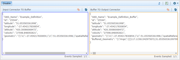
- GeoEvent Sampler, the utility that allows you to sample your event data as it’s streaming, is now open by default in the service designer.
- Enhancements to several processors including the Buffer Creator Processor, Range Fan Calculator Processor, and the Field Enricher (Feature Service) Processor.
Now, let’s take a deeper dive into each of these exciting new enhancements and more!
New add-on manager
At this release, you’ll find a brand-new way to interact with add-ons available in the ArcGIS GeoEvent Server Gallery. The gallery has been available since the first releases of GeoEvent Server, but with the new add-on manager in ArcGIS GeoEvent Manager, you can more easily explore, install, and manage all the add-ons that are available to you.

GeoEvent Server add-ons extend the out-of-the-box capabilities by allowing you to add connectors for third-party data formats and protocols as well as processors used to perform real-time analysis on your streaming data. For more details on working with the new add-on manager, head over to the latest Esri Community blog, New GeoEvent Server Gallery Add-on Manager in ArcGIS GeoEvent Server 11.1, that walks you through all the details of using the new add-on manager.
If you have real-time use cases and analytic workflows that are not supported with the out-of-the-box connectors and processors or add-ons, review your other options for extending GeoEvent Server.
GeoEvent Manager enhancements
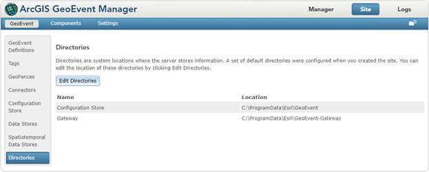
ArcGIS GeoEvent Manager is the app used to create your real-time workflows and administer GeoEvent Server. With the 11.1 release, a new Directories page is available from the Site tab that allows you to easily update both the Configuration Store and Gateway directories used by GeoEvent Server.

When GeoEvent Server is installed, default directories for the configuration store and gateway are chosen as illustrated above. In previous releases, to change these directory locations, you had to edit files in the installation location. One of the drawbacks of this manual approach was that when you upgraded GeoEvent Server to a new version, those files were overwritten. With this new approach, your directory locations are saved upon upgrading.
Now you may be asking, “why would I want to change these directories?” Well, there may be circumstances when you have limited disk space available on the system drive you installed GeoEvent Server. Per the Kafka on-disk storage topic, with a new installation of GeoEvent Server, the ArcGIS GeoEvent Gateway service requires at least 1GB of disk space. Each input or output you add requires a minimum of 720MB additional disk space, even before any event data is processed. Many organizations have numerous inputs and outputs and other elements configured that are processing lots of real-time data, which can quickly fill up disk space. The new Directories page provides an easy way to change these directories to a location that has sufficient disk space for your real-time workflows.
And lastly, to improve your experience in GeoEvent Manager, several enhancements were made behind the scenes to improve load times and performance of the app, making you more effective when working with GeoEvent Manager to define all your real-time workflows.
GeoEvent Sampler is open by default
The GeoEvent Sampler, which allows you to sample a fixed number of GeoEvents as they’re routed through your elements (inputs, outputs, filters, and processors) of a published GeoEvent Service, is now open by default in GeoEvent Manager.

The real benefit of using GeoEvent Sampler is that you can see the raw data flowing between two elements as well as visualize that data in a web map directly in GeoEvent Manager. You gain immediate insight, giving you the ability to validate and troubleshoot any issues early in your workflows.
Enhancements to processors
Processors allow you to perform real-time processing and analysis on your streaming data as it flows through GeoEvent Server. Many processors are available out-of-the-box with GeoEvent Server, and more are delivered as add-ons on the GeoEvent Server Gallery. For more on add-on processors, review details about the new add-on manager above.
In this release, some useful improvements were made to several processors available in GeoEvent Server. To start, the Buffer Creator Processor was enhanced to support geodesic geometry as well as expressions that can include literal strings, numeric constants, and event data taken from named fields in the event being processed. This is similar to what the Field Calculator Processor has been able to do for some time.
Like the Buffer Creator Processor, the Range Fan Calculator Processor was also improved to support expressions that can include literal strings, numeric constants, and event data taken from named fields in the event being processed, again similar to the Field Calculator Processor.
And lastly, the Field Enricher (Feature Service) Processor now supports setting a cache refresh interval of less than a minute, the fastest refresh interval now allowed is 10 seconds.

This is important in use cases when you’re enriching (or joining) event data from another feature record, the enrichment data could be out of date within that 1 minute. For more information and considerations on the appropriate values to set for the cache refresh time interval, see the GeoEvent Server: Field Enricher (Feature Service) blog on the Esri Community.
And more…
For a complete list of enhancements with more details, check out the What’s new topic in the documentation. For a list of issues that were fixed in GeoEvent Server at 11.1, see the 11.1 Issues Addressed List. And, if you have ideas, enhancements, or feature requests, post them on the ArcGIS GeoEvent Server Ideas board in the Esri Community.

Article Discussion: