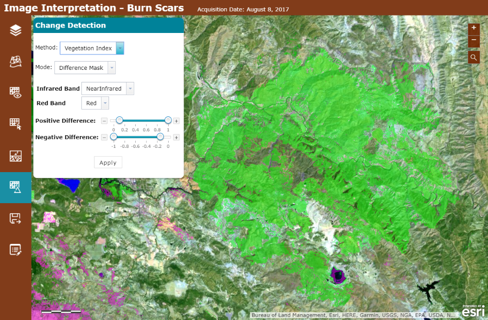
With the Image Interpretation app template, now released in beta, you can create an interactive web app that lets people view, understand, and annotate imagery, no coding necessary. Straightforward configuration options let you customize the app for your project, whether you’re enabling first responders to interpret aerial imagery after a natural disaster, providing farmers with a tool to identify their land and record crop types, or creating an app for a property appraiser to record notes about newly constructed houses. Use your imagination to explore how this free, easy-to-use app template can make your life simpler.
 Apps created with the Image Interpretation template have the option to include a wide array of tools for navigating and interpreting imagery. Apps built with the template can do the following:
- Visualize both imagery layers and non-imagery layers sourced from the app’s web map
- Select specific images from a layer to visualize and compare
- Render imagery using functions associated with the layer in the web map
- Compare images using swipe and transparency
- Perform change detection to compare two images, or to compare calculated indexes for vegetation, burned area, and water
- Perform image measurement on imagery layers that have mensuration capabilities
- Edit feature layers (so you can pinpoint or digitize areas of interest, for example)
- Export an imagery layer to the user’s local machine, or as layer in the user’s ArcGIS Online account
Because apps built with the template use web maps created in ArcGIS Online, you can incorporate your own imagery content as a dynamic image service or tile cache. You can also take advantage of a wide array of ready-to-use image services like Landsat or NAIP through the Living Atlas. Imagery datasets available from the Living Atlas include archived and recent high-resolution imagery for most of the world, lower-resolution imagery updated daily, and near real-time imagery for parts of the world impacted by major events, such as natural disasters.
Creating an app using a configurable app template is simple.
- Create a web map with your imagery on ArcGIS Online.
- Create an app using the Image Interpretation (beta) web template. Since the Image Interpretation template is still in beta, you’ll need to seek out the template—it won’t be available with the rest of the app templates. To find it, make sure you’re logged in to ArcGIS Online; search for “tags:Imagery Interpretation Template”; and make sure you uncheck “Only search in <My Org Name>”.

- Click on the “Image Interpretation (beta)” title to go to the ArcGIS Online item, click “Create a Web App,” enter a title and tags, then select your web map.
- Configure your app with a suite of tools for image interpretation—you choose which tools belong in your app, and how you want them set up.
- Save and launch your app!
Check out Getting started with the Image Interpretation (beta) Configurable App for a more detailed, step-by-step tutorial for how to set up and use an example app.
Feeling ambitious? With a little programming know-how, the Image Interpretation app template is also customizable. Everything you need to get started tweaking the template and making it your own is in the Image Interpretation GitHub repository.
Look for more documentation coming soon. Until then, play with a live app created using the template, or get creative and make your own app. Don’t forget to check out the Imagery and Remote Sensing community on GeoNet to ask questions, make suggestions for improving future versions of the template, and to show off your apps.

Article Discussion: