ArcGIS Insights 2020.2 has arrived, with even more power to perform visual analytics on your data. Here’s a quick overview of some highlights:
- Analytics – Schedule your analytical operations to automatically re-run and fuel your shared Insights pages with the most up to date changes. It’s now easy to ensure your interactive reports reflect the current state of your data. Also, three new spatial analysis tools (spatial mean, calculate density ratio, and find k-means) have been added, and the calculate density tool has been completely reworked.
- Mapping – Enjoy greater control over the map pop-up, map legend, zoom extents, and more.
- Charting – Significant improvements have been made to to the time series and combo chart, and even more chart labeling choices are available.
- Reporting – Improvements were made for creating compelling and interactive visuals, including predefined filters as a drop-down, card ordering and stacking, additional text and font control, and more.
- Data connectors – Two new data connectors (SharePoint and OneDrive) allow you to pull in any of the supported flat files. Also, Microsoft SQL Server now supports OS database authentication.
- Packaging and sharing – Workbook package files allow you to distribute your work easily to any other Insights analyst needing to modify or understand your methods.
Let’s take a deeper look at the details…
Scheduled Refresh of Analysis
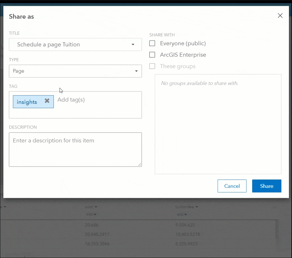
Reports must reflect the current state of data, and Insights now supports automating your analysis. Insights will update your visualizations, and even processes the entire analysis tool chain used to create derived information. When sharing an Insights page, schedule it to update on an hourly, daily, weekly, or monthly basis. Scheduled refresh is now available within ArcGIS Enterprise, and coming to Online with the next release.
In the video below, see how page sharing has the option to schedule updates.
Analytics
Three new spatial analysis tools have been added to your toolbelt, and another was drastically improved.
Spatial Mean calculates the geographic center for a set of point features. This is useful for understanding the location trend for any type of event (customer sales, crime, deliveries, repairs, etc.).
K-Means Cluster finds clusters of similar features based on either physical proximity or attribute values. When location is specified, spatial k-means clusters creates natural groupings of the features based on closeness. When attribute values are used, the algorithm classifies records into natural groupings that are as different as possible.
Calculate Density is completely updated to use the kernel density algorithm, and the output is now a more accurate vector data set that can be re-used for further analysis. Point features are input to generate a density surface that communicates where there are higher and lower concentration areas.
Density Ratio creates a relative risk surface, using the same calculate density methodology described above. However two different datasets are used to create the ratio – one data set is the numerator, and the other is the denominator. This would be useful for example to understand the location of patient cases, normalized by the total population.
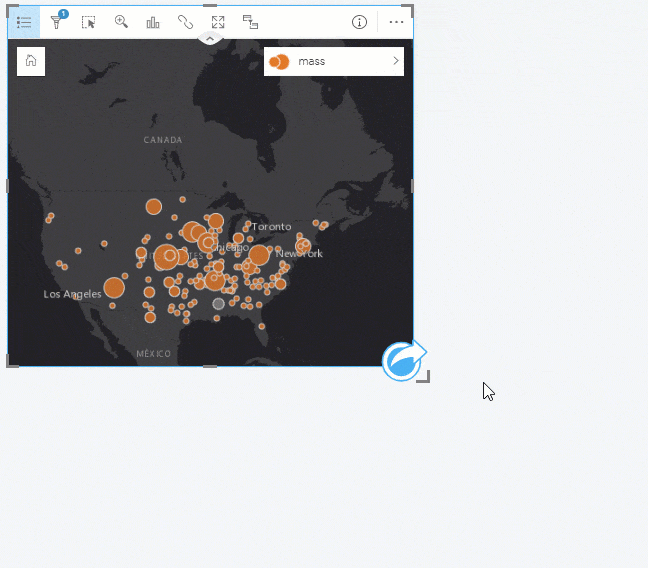
In the below video Find K-Means Clusters analysis is used to group the point locations into 7 territories or regions, based on closeness. Alternatively, numeric values could be used to cluster the dataset.
The below video uses Calculate Density analysis to determine the concentration of meteorite sightings. Calculate Density Ratio can also compare this output against population.
Mapping
Mapping is even better with enhancements to the map card. This includes:
Map pop-ups are configurable. You’ll notice the option to turn them off completely, or to simplify them by removing the statistics from being shown.
Map legends are now configurable to rename, resize, and reposition. The legend count values may also be removed.
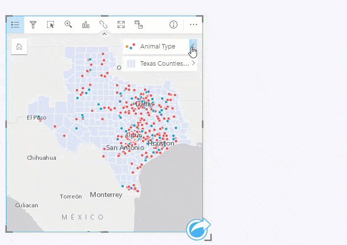
Map extents have more control. Analysts have the ability to define the default map extent, and a zoom to layer option has been added.
The Map layer list can be hidden, and provide a more simplified view without visual obstruction of the map.
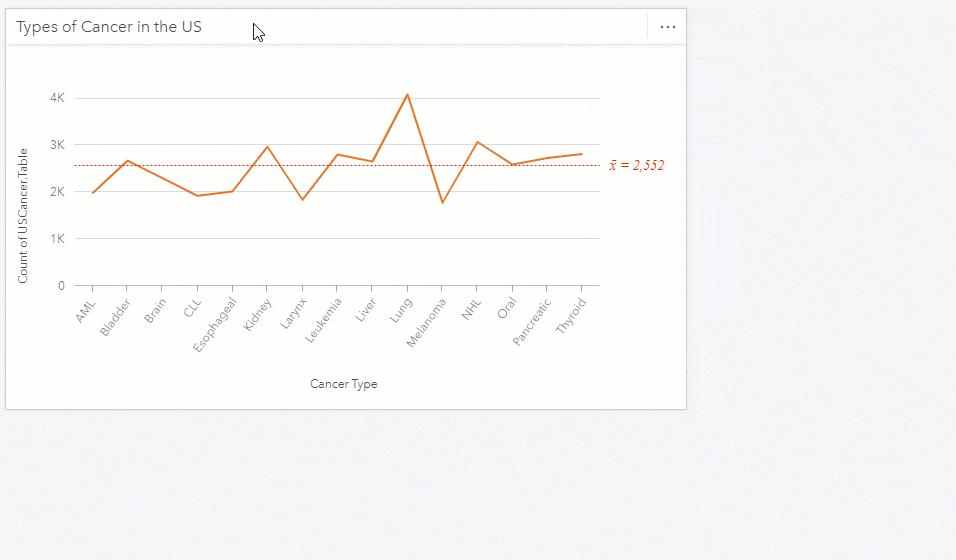
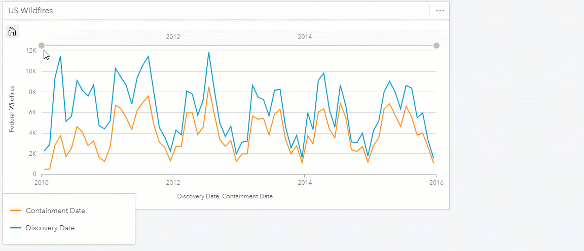
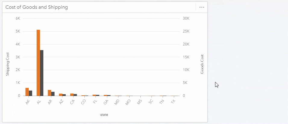
Charting
Many charts now animate when they load and come with more options, while retaining the easy to use experience.

Chart labeling is available to the bar, column, line, and combo charts. Each has a toggle switch to show value labels, and settings for choosing between different position and orientation settings. To better support small numbers, choose up to 5 decimal places in your labels.
Time series cards have a slider for panning and zooming into an interval and examining in more detail. Also, multiple date-time fields can now be used within the same card at once, and a shading option is available.
Combo charts are able to synchronize the two y-axis values and use the same single shared y-axis scale.
Line charts now have line smoothing available, and this is especially useful when trying to show a trend that is unlikely to have sudden changes, such as temperature by month and is a good way to visualize patterns like seasonality.
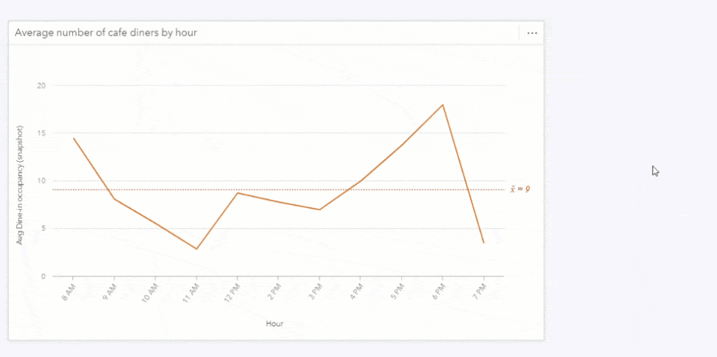
The KPI card can now be made smaller, and allows for customizing the target text descriptor.
Interactive Reporting
Interactive reports are critical for sharing your analysis with viewers. These following improvements have added to the dynamic experience.
Predefined filters have been around for some time, but now they are updated with the option to select filters as a drop down. This reduced the screen space of predefined filters significantly. To help locate a specific value, users can now search for the filter categories.
Analysts can now hide the chart and map toolbars, for a very simplified viewer experience.
Analysts can also reorder page tabs within a workbook, for communicating results sequentially across multiple pages.
When multiple cards are stacked, now choose the preferred z-ordering of cards, much like you would do for a presentation slide deck with send to back, send to front, etc.
Card titles and axis labels can now have their font adjusted at the page level, through one setting that manages a consistent look and feel across the entire page.
Data Connectors
Insights browser applications can now connect to both SharePoint and OneDrive datasets. If your data is stored in an .xlsx, .csv, shapefile, .json, or .geojson, now directly point to it within these storage locations. The SharePoint connection also supports lists, subsites, and document libraries.
For organizations relying on operating system database authentication to access SQL Server, data became a lot more reachable. You’ve likely heard of OS authentication for access to applications, well this is similar except that it’s controlling access to the data. The benefit is that you can use the same username and password that you’re used to, no need to remember yet another.
Packaging and Sharing
Workbooks can now be packaged, shared, and re-opened. Analysts can easily collaborate on analysis projects together, and these packages are interchangeable between the Online, Enterprise, and Desktop deployment options. Workbook package files have a “.insightswbk” file extension, and contain all of the visualization, analysis, and data needed to re-open it.
And More
Accessibility for people with disabilities and limitations has been significantly improved, with detailed considerations for both keyboard navigation as well as screen reader support. Entire workflows may be accomplished across the entire Insights user experience.
The ability to search for a field in the data pane allows you to quickly find fields when your dataset has many fields, instead of having to scroll through them all.
For a complete list with more details, check out the what’s new help documentation topic.
We have lots of free training available, including new COVID-19 learn lessons. There are many user stories to review, and check in with the Insights user community. Until next time, enjoy!

Article Discussion: