Welcome to another release of ArcGIS Insights, the self-service location analytics workbench that combines traditional BI-like workflows, open data science, and GIS capabilities. Insights thrives at exploring data to refine questions, and minimizing the time-to-value when going from data to answers within an interactive report.
We listened to your feedback and used this release to concentrate a lot on quality and performance. In addition to quality, we also squeezed in some big enhancements. Highlights include spatial support with Snowflake, Google BigQuery, and custom Java Database Connectivity (JDBC) connections. We’ve also added SAP HANA Cloud as a fully supported data connection. Scatterplots have been expanded to include binning for improved visualization of big datasets. Here are the details:
Spatial support for data warehouses, cloud databases, and custom JDBC data connectors
Snowflake and Google BigQuery connections now have even more capabilities than before, with added support for spatial data. Connect to that data where it lives (without extracting it), spatially-enable it, visualize it (using maps, charts, and tables), analyze it, and create interactive reports with context. Queries and operations are pushed to the datastore, so speedy performance comes directly from the benefits of these cloud data warehouses.
Today you can do the following with data living in Snowflake and BigQuery:
- Use existing spatial data (points, lines, and areas) natively stored in the cloud data warehouse.
- Enable location for latitude and longitude coordinates using World Geodetic System 1984 as a spatial reference.
- Map with advanced visualizations such as binned maps, heat maps, link maps, and other map symbols.
- Calculate geometric properties of area, length, and perimeter.
- Perform spatial analysis operations like spatial filter, spatial aggregation, and find nearest.
…and even more spatial support is coming soon!
SAP HANA Cloud is also now a fully supported data store. This means that the same workflows outlined above, and much more, can be accomplished with data coming from your SAP HANA Cloud environment.
Additionally, custom JDBC data connectors (in preview) now support these spatial data workflows. JDBC connectors allow you to connect Insights to any file type or data source with a JDBC file. Check out the sample connectors to get started with your custom data connector.
This 3-minute video provides a concise overview of how to create database and data warehouse connections within Insights.
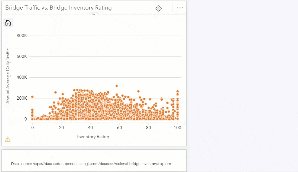
Scatterplot binning
If you’re a GIS analyst, you know the benefits of a binned map – it’s much easier to see and understand binned data when there are too many points on the map.
The same holds true for scatterplots. When there are too many points on the chart, bins allow you to clearly see a pattern.
In the below example, see how we can go from a blob of overlapping points to a representation of graduated color bins, revealing a pattern. The pattern shows that the highest concentration of bridge repairs have a rating score of 35, and traffic count of around 75,000 vehicles per day.
Scripting: Spark and Koalas DataFrames
The Insights scripting console provides access to Python and R libraries so that data and charts can be passed simply between Insights and your scripting environment. Spark and Koalas are two Python libraries commonly used for distributing and processing big data. Now, analysts can seamlessly convert Koalas and Spark DataFrames into Insights datasets. This means you can continue to use these Python libraries, directly within Insights. The performance of importing data into the kernel and exporting data back into Insights has been improved for performance as well.
And more…
For a complete list and even more granularity of details, check out the Insights help documentation “What’s new” topic. Don’t forget, Insights is in ArcGIS Online (a SaaS), available as a native desktop app (Windows and Mac), and Insights in ArcGIS Enterprise can be found within MyEsri (it supports ArcGIS Enterprise 10.9 and 10.8.1).
What’s next
To assist you in getting started quickly, there’s lots of resources available. Some newer content is an implementation guide for ArcGIS Enterprise, a learn lesson for using Insights with ArcGIS Field Maps, and a learn lesson for data driven policing. The product resource page is a great stop for material like this, including a free 21-day trial.


Article Discussion: