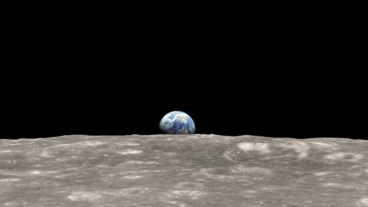
Amidst the COVID-19 pandemic, today we celebrate the 50 year anniversary of the first Earth Day. The talks that day, Wednesday 22 April 1970, were inspired in part by a striking image of the rising earth taken from the moon on Christmas Eve 1968. Inspiration had come from the book Silent Spring by Rachel Carson, which had eloquently pointed out how badly human behavior had affected the planet. And there were many other coincidental, tragic events that formed the genesis of this event. 20 million Americans took part. The talks that day sometimes seemed to be filled with anecdotal, disconnected platitudes and many skeptics thought that Earth Day was merely going to be a short-lived fad. Even though there were many examples of localized devastation from pollution that was out of control, many people then could not see the evidence of a worldwide crisis. Despite some skepticism, on that day, an environmental movement was born in the US and before the end of the year, the Environmental Protection Agency was created. In 1990 Earth Day went global, inspiring concern and action for environmental issues across the planet.
Satellite Imagery Makes an Impact
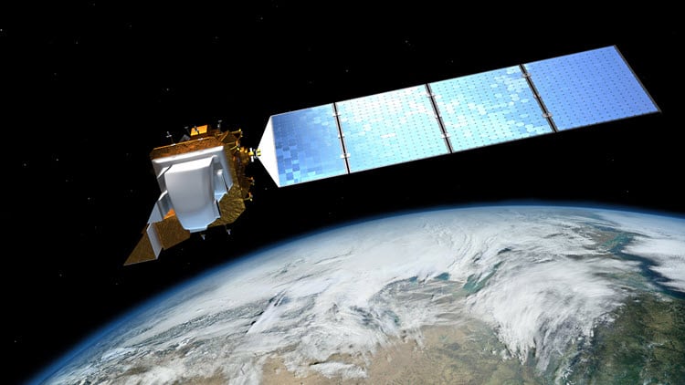
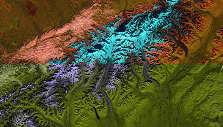
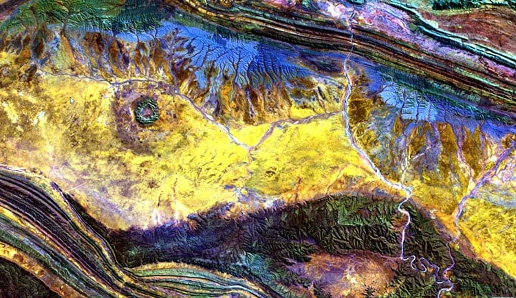
For humans, seeing is believing because so much of our nervous system is dedicated to vision. So how could those responding to the call to action provide the poignant visuals needed to make their point? At that time in 1970, there were teams in the US that were working diligently and quietly on technologies that would let everyone see the state of the earth from the perspective of space. The goal was to provide policy makers and the public the necessary identification and understanding of the issues. The USGS and NASA were building the first Earth Resources Technology Satellite (ERTS) which would later be renamed Landsat. This effort leveraged the knowledge and space technology that had been developed in the 1960s. In 1972, Landsat-1 was launched. Though TIROS-1, the first weather satellite, had been beaming low resolution pictures of earth to ground stations for a dozen years, it did not show the detail that connected human activities to environmental concerns. But now, Landsat‘s medium resolution imagery was sufficient to show the impact of anthropomorphic change on the entire earth surface, every 16 days. Looking back, Landsat-1 was both a humble and momentous beginning. Landsat imagery and the many new imagery sources that followed, have not only given scientists the evidence they needed to understand and explain environmental dynamics, these global sources have done it in a manner that is vibrantly visual.
New Imagery Sources
In 1970, the only imagery generally available was an unregistered black & white aerial photograph on printed material. In contrast, today imagery is multispectral digital and precisely geopositioned in near real time. The advancements are due to better sensors, inherent global positioning, computing advances, and communication capabilities that were barely imaginable on Earth Day 1.
There are now 100s of imaging satellites orbiting the earth, providing a wide variety of resolutions, with sensors that look across the electromagnetic spectrum. They range from passive electro-optical sensors, to active lasers, to radars. Airborne sources augment this capability, and with commercial drones, remote sensing is becoming personal just like the PC did for computers. These all deliver rich data that fuels your GIS to drive analyses and provide insights not previously obtainable.
It was critical to get remotely sensed imagery of the earth, but to be truly transformational, a lot of technology development would be needed over the ensuing decades to be able to effectively manage and analyze this image resource.
GIS and Imagery Analytics
In 1970 you were challenged to georeference an air photo and in the later 1970’s it was still difficult to print a Landsat image. Today we can routinely analyze well characterized digital imagery and make determinations about vegetative health, derive sea surface temperatures, provide wind speed and direction from Doppler radar, make damage assessments for humanitarian relief, build precise elevation datasets from LiDAR, derive rich land use land cover maps, detect subtle terrain elevation changes using radar, identify gas emissions with hyperspectral imagery, find poor insulation with thermal infrared sensors, and the list goes on and on.
Once we have these datasets, the GIS can provide synoptic views, and more importantly, analyze the meaning of this information relative to other geographic data such as demographics, infrastructure, agricultural resources, natural resources, and hypsographic data. We not only derive information, we can determine the impact toon specific portions of specie populations, the built-up world, and the natural world.
These analyses are possible because of rich image processing techniques, photogrammetry, and good sensor characterization. The technology is advancing rapidly with new techniques that use machine learning and artificial intelligence (ML/AI).
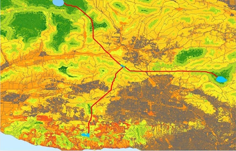
Image Management
In the 1970’s imagery acquisition was a time consuming, expensive and challenging prospect. The data was all hardcopy and you were lucky to have an image in the current year. Today we have become accustom to looking at imagery from our desktop or even our phones. Moreover, we can see any location on the planet, instantly. This is made possible by modern image management technology, cloud computing, and high bandwidth communications. This is making a significant difference for problems that requires timely response and involves responders in remote locations.

The Things That We All Face
On the 50th anniversary of Earth Day, we face the impact of a zoonotic virus, one that apparently jumped from bats to humans. The novel COVID-19 virus has disrupted daily human activities, killed 10s of thousands and slammed the world economy. It is a reminder of how our interactions with nature can go horribly wrong, and that humans and nature are inextricably linked. Earth processes are dynamic and constantly changing, sometimes resilient and other times delicate, but always responsive. An all too common belief is that our human activities are incapable of influencing environmental dynamics in any substantial way. Anyone that has faced the power of a hurricane would certainly feel that way, or conversely, anyone trying to generate a breeze that causes a stand of trees to bend and topple. However, we humans have had a significant hand in global change, such as:
- Opening the ozone gap in the upper atmosphere with Freon and other damaging aerosols
- Changing the balance of the ocean with pollution from chemicals, plastics and refuse
- Driving species to extinction through habitat disruption
- Disrupting the ocean food chain by over fishing and destructive by-catch of apex predators like dolphins and sharks
- Changing the balance of the atmospheric gases in a way that affects global warming
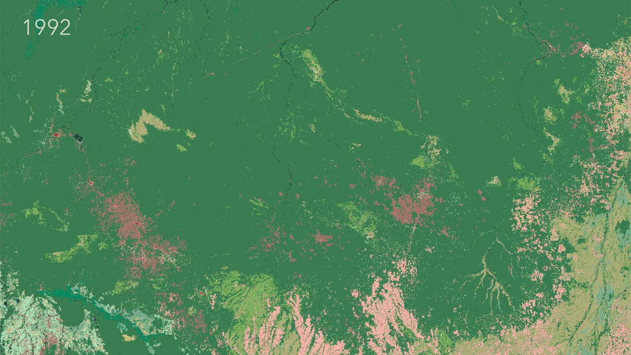
- Massive deforestation globally over centuries, especially in the tropics the past 50 years
- Rapidly increasing glacier retreat and loss of sea ice
In turn, all these changes affect us in very adverse ways. The challenge is to convince people, businesses, organizations, and governments that we need to change first our perceptions, then our behavior. Sylvia Earl pointed out that:
Any astronaut can tell you you’ve got to do everything you can to learn about your life support system and then do everything you can to take care of it. Sylvia Earle
We should heed her advice about our life support system, the environment, here on spaceship earth. Diverse environments are more stable, resilient and healthier than damaged or compromised environments.
Where We Are in 2020
In contrast to the state of technology 50 years ago, we have substantial tools today to model, understand and manage our efforts to build a sustainable future. GIS has evolved dramatically over this time as well as the remote sensing technology that can fuel it with timely data. Remote sensing technology is the vision portion of the GIS nervous system, constantly updating the analytic engines within the GIS. Derived information flows into resources like the Living Atlas, where it can readily provide actionable data and status to the appropriate constituents.
A Sustainable Way Forward
Green policies that avoid damage are almost always cheaper than brown policies that clean up disasters. But this is difficult to convey. People responding to needs of basic necessity, or in some cases acting out of selfish greed, will often take action that is expedient and damages the environment. The net result is that we have an issue to clean up, resulting in brown policies that are expensive and difficult to enact..
Jane Goodall observed that in order to help the wildlife in Africa, you first need to help humans solve their own problems. This is a foundational concept of the Roots to Shoots organization. In one of my discussions with Jane, she commented to me that ”our balance with nature will only happen when humans can connect their brains with their hearts”.
Connecting the brain, to the heart, to the Earth, involves the gathering of data and spatial information, analyzing it, and synthesizing seemingly disparate information to make associations such as cause and effect, multidimensional relationships between manmade and natural environments. Esri’s partners and community of users apply GIS and image analysis technology to assess, manage and monitor environmental processes.
Our active and passive management of environmental processes are tied to the policies enacted by people, businesses, organizations, and nations to protect the environment and conserve resources for next generations in a sustainable manner. This is the connection between the brain and the heart. Wise, informed management focused on stewardship of the environment and resources helps ensure that humans, other animal and plant species, and earth processes work in concert to preserve the essential fabric of the environment. The environment that we all depend on for an enriched quality of life on Planet Earth.
We must celebrate all the progress the environmental movement has made in past 50 years to bring new perspectives and remedy egregious behaviors. We are certainly in a better place than we were in 1970. However, we have a lot more work to do to. All the efforts are important. So, let’s do the little things, continue the dialog, change minds, change business practices, change our laws and regulation if required, and by all means get involved to build a sustainable place here on earth.
We would like to acknowledge and thank Jeff Liedtke for his contributions to this blog.

Article Discussion: