Esri and 3DR partnered to create a metadata file suitable for input into the Esri FMV Video Multiplexer tool to create MISB-compliant videos. Flight and sensor metadata from the 3DR Solo drone is recorded into a TXT file, which can be easily downloaded from the Solo and converted to the required CSV (comma separated values) format. The sensors recording the metadata are coordinated with the capture of video data to ensure synchronization.
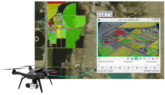
The Solo metadata file and video data are input into the Esri FMV Video Multiplexer tool to create a single MISB-compliant video. This MISB-compliant video results in the graphic display of each video frame on the map display in ArcGIS. This powerful capability also enables the seamless creation and update of features in both the video player and map display, measurement of features, and bidirectional marking of features in the video and map display.
Esri provides a document that describes how to update your Solo drone with the firmware programs, also included, in a download via GeoNet.


Article Discussion: