By Dr. A Jon Kimerling, Professor Emeritus, Oregon State University
Have you ever wondered how you can figure out how far the viewing distance is from the center point of any map? For example, in my office I have a large map of the world on my wall. It has a scale of 1:9,000,000. How can you tell the viewing altitude for the map? This is a very good question that I was asked recently.
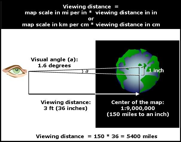
First of all, the altitude depends on the map’s scale and then on your viewing distance away from the center of the map. Say you are viewing the map from 3 feet away. The map is at a scale of 1:9,000,000 at its center, which is about 150 miles to the inch. One inch on the map will subtend an angle found from the equation 2*tan(0.5″/36″), giving an angle of 1.6 degrees at this viewing distance. This subtended angle must be maintained at a scale of 1:1, meaning that there must be a 36 to 1 ratio of viewing distance to ground distance. Hence, the viewing distance (altitude) would be 36 times 150 miles, or about 5400 miles above the surface, and the general equation for viewing distance is simply map scale in miles per inch times the map viewing distance in inches. In metric terms, the equation would be map scale in kilometers per centimeter times the map viewing distance in centimeters.
Article Discussion: