By Aileen Buckley, Mapping Center Lead
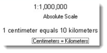
A verbal scale is also referred to as a “word statement” or a “scale expression”, and in the ArcGIS software, it is one of the options for inserting “scale text”. It is offered in the form of a relationship between map distance and ground distance stated in standard units that we understand for both sides of the relation. For example, if we say that a map that is “one inch to the mile”, we understand (at least in the U.S.) the units on both sides of the relation. This is the same as a map that is 1:63,360, but for many map makers and map users, we will often translate this mentally into “one inch to the mile” because we can intuit that more easily (figure 1).
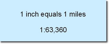
Figure 1. A verbal scale helps map readers to understand the scale reduction in terms of units they can more easily imagine
A verbal scale is inserted the same way as a representative fraction – click on Insert on the top bar menu and select Scale Text (figure 2). All but the first options are verbal scales – choose the one that will make the most sense to your map readers. After you select one, you can change many of its properties. Once inserted, you can also double click the verbal scale to change even more properties.
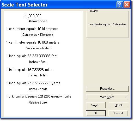
Figure 2. The ArcMap dialog box to insert scale text
Advantages and disadvantages
This is a useful scale indicator if the map units are something that can be measured easily. For example, on a map that is one inch to the mile, we also need to know how long a mile is on the map – a scale bar can help us (make sure the subdivision length is 1 mile) or some common mile-long features can help us. For U.S. maps, common mile-long units might be mile markers along roads if they are indicated or the U.S. Public Land Survey System for which most sections are one mile along a side. If we cannot determine the map units, a verbal scale is best used to help us understand the amount of reduction that took place to make the map. Like RFs, verbal scales become invalid if the map is enlarged or reduced in size.
Design
As with representative fractions and scale bars, the text for a verbal scale should be subtle and should not draw the attention of the map reader. Map readers should have to shift their attention in order to find it on the page. The font size for the verbal scale should be some of the smallest text of the page.
If you use verbal scale with an RF, you can stack and align the two pieces of text (use the Align and Distribute tools on the Draw Toolbar). If you use it with a scale bar, follow the same guidelines as using an RF with a scale bar. Place the verbal scale directly above or below the scale bar. Which you choose will be determined by the layout of your map, but usually it is shown above the scale bar. The font for the verbal scale should match the text for the scale bar in order to keep both at the same visual plane and to relate them visually for the map reader.
Uses
As with representative fractions, verbal scales are often used on large-scale maps and planning documents, most frequently used by civil engineers. You will find them on some smaller scale maps but not as often as you will representative fractions. Some standard map scales already have the verbal scales calculated and you could easily use that. Refer to Map Use by Kimerling, Muehrcke and Muehrcke for a full discussion, and a good one, on verbal scales, as well as the other scale indicators.

Article Discussion: