By Aileen Buckley, Mapping Center Lead

Take a minute to check out our ArcGIS Resources – Styles page and you will see that we have included graphics of the contents of the styles you can download from Mapping Center. This will make it easier for you to find out if a style has the symbols you are looking for before you download the file. Of course, some of the symbols will be a little hard to see in their full glory in these screen captures (for example, marker symbols that are bigger than the space allotted in the ArcMap Style Manager large thumbnail view.) However, you can still get a good idea of the contents.
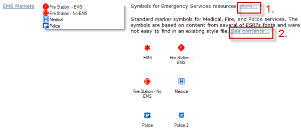
The thumbnail at the left gives you a quick glimpse into the style. Click on the “more…” link 1. in the example below) to see a written description of the style contents. Then click on the “See contents…” link 2.in the example below) to see the symbols in the style. To collapse the graphics in the display, simply click again on the “See contents…” link.
We hope you will take the time to peruse the styles – maybe there is something in here that you will find useful!

Article Discussion: