Across Organizations, Across Communities, Across the Globe
The geographic organizing aspect of GIS has been part of the thinking from the beginning, but now factor in the impact of the web. Web GIS provides an online infrastructure for making maps and geographic information available throughout an organization, across a community, and openly on the web. This new vision of Web GIS fully complements, integrates, and extends the work of existing GIS professionals.
Web access to data layers is straightforward: every layer has a web address (a URL) making it easy to locate and share online. Because every layer is georeferenced, Web GIS becomes a system for integration that facilitates the access and recombination of layers from multiple providers into your own apps. This is significant for the millions of GIS professionals worldwide who are building layers that serve their individual purposes. By simply sharing these layers back into the online GIS ecosystem, they are adding to a comprehensive and growing GIS for the world. Each day, this resource grows richer and is tapped by ArcGIS users and shared on the web.
GIS is continually evolving. Its information model was originally centered around local files on a single computer. From there, it evolved into a central database environment based on clients and servers. The most recent evolutionary stride has taken it to a system of distributed web services that are accessible in the cloud. ArcGIS is now a Web GIS platform that you can use to deliver your authoritative maps, apps, geographic information layers, and analytics to wider audiences. You do this by using lightweight browser clients and custom applications on the web and on smart devices, as well as desktops, as you’ll see in later chapters.
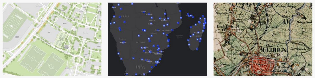
These three layers depicting Harvard University facilities, global airport locations, and Dutch historical maps, respectively, are among thousands available on ArcGIS Online.
Much of the work of traditional GIS users and experts has involved building and maintaining key foundational layers and basemaps—information products that support a particular mission. Huge investments have been made to compile these basemaps and data layers in great detail and at many scales. These include utility networks, parcel ownership, land use, satellite imagery and aerial photography, soils, terrain, administrative and census areas, buildings and facilities, habitats, hydrography, and many more essential data layers.
Increasingly, these information products are finding their way online as maps, comprehensive data layers, and interesting analytical models. This data comes to life for everyone as a living atlas, a collection of beautiful basemaps, imagery, and enabling geographic information, all of which are built into the ArcGIS platform. There, they are available for anyone to use, along with thousands of datasets and map services that have also been shared and registered in ArcGIS by users like you from around the world.
Web GIS is Collaborative
Every day, millions of GIS users worldwide compile and build geographic data layers about topics critical to their work and for their particular areas of interest. The scope of information covers almost everything—rooms in a building, parcels of land, infrastructure, neighborhoods, local communities, regions, states, nations, the planet as a whole, and beyond, into other planetary systems. Web GIS operates at all scales, from the micro to the macro.
Geography is the organizing key; information in Web GIS is sorted by location. Because all these layers share this common key, any theme of data can be overlaid and analyzed in relation to all other layers that share the same geographic space.
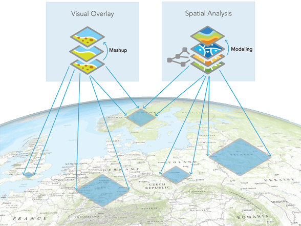
Visual overlay and spatial analysis can be applied to any patch of geography of any size on the planet.
This is a powerful notion that was well understood by mapmakers in the pre-digital era: tracing paper and later transparent plastic sheets were employed to painstakingly create “layer sandwiches” that could be visually analyzed. The desire to streamline this process using computers led to the early development of GIS. The practical term for this notion is “georeferencing,” which means associating things using their locations in geographic space.
Now extend the idea—of georeferencing shared data— onto the web. Suddenly it’s not just your own layers or the layers of your colleagues that are available to you, it’s everything that anybody has ever published and shared about any particular geographic area. This is what makes Web GIS such an interesting and useful technology; you can integrate any of these different datasets from different data creators into your own view of the world, overlay them and then perform spatial analysis.
—–
This post is excerpted from The ArcGIS Book, Second Edition: 10 Big Ideas about Applying The Science of Where, by Christian Harder and Clint Brown. The twin goals of this book are to open your eyes to what is now possible with Web GIS, and then spur you into action by putting the technology and deep data resources in your hands. The book is available through Amazon.com and other booksellers, and is also available at TheArcGISBook.com for free.
Commenting is not enabled for this article.