ArcGIS Urban serves two main purposes. It is a tool for planners and designers to collaboratively iterate across different development scenarios. It allows users to quantify and compare the effects of different planning strategies before sharing them with the public. In addition to that, ArcGIS Urban also serves as a platform where citizens can explore the current developments in their city.
During the early phases of the planning process, only internal staff needs access and authoring permissions for a plan; however, as the planning process progresses, it will eventually become necessary to share and involve the public. To support these different needs regarding the availability of information, ArcGIS Urban comes with two different views: a public content view and a design content view.
The public content view
The public content view is the system of records, where citizens can explore the three-dimensional representation of their city, can look at a curated subset of published plans and projects, and express their development-specific feedback.
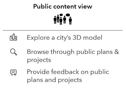
Capabilities in the public content view of ArcGIS Urban
The administrator of an Urban Model can configure who can access the public view, who can upload new data, and who can publish plans and projects.
The design content view
The design content view is primarily intended for planning staff. It requires users to have an ArcGIS Urban license and access to the public content view. The design content view shows all the public content as well as all designs that are associated with the Urban Model and that are shared with the licensed user. The design content view usually looks slightly different for every licensed user because not every user has access to the same plans and projects.
Whenever a user adds a plan or a project in ArcGIS Urban, the newly created design is by default only visible to the user who created it. It can then be shared with the relevant stakeholders who are, together with the creator, collaboratively working on the scenarios. Once the planning efforts are ready to be made available to the public, an Urban Model administrator can publish a more polished copy of the plan or project to the public content view.
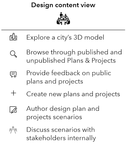
Capabilities in the design content view of ArcGIS Urban
Use case examples
The concepts of a public and a design content view allow a nuanced definition of what content and which capabilities are accessible to which users. Learn from three use cases examples how the access to the public content view can be configured and how the public and design views interact with each other.
Use case 1 – Share an Urban Model
Assume the fictional City of Urbanville deploys ArcGIS Urban. The mayor of Urbanville wants to use the public content view to inform the public about ongoing urban development projects. The task of administrating the Urban Model should be shared among the group of senior planners of the city.
Solution:
To meet the requirements of Urbanville, the creator of the Urban Model needs to configure it in the data manager as shown below:
- The public content view is accessible to the public.
- The members of the Senior Planners group can edit the Urban Model and are therefore administrators.
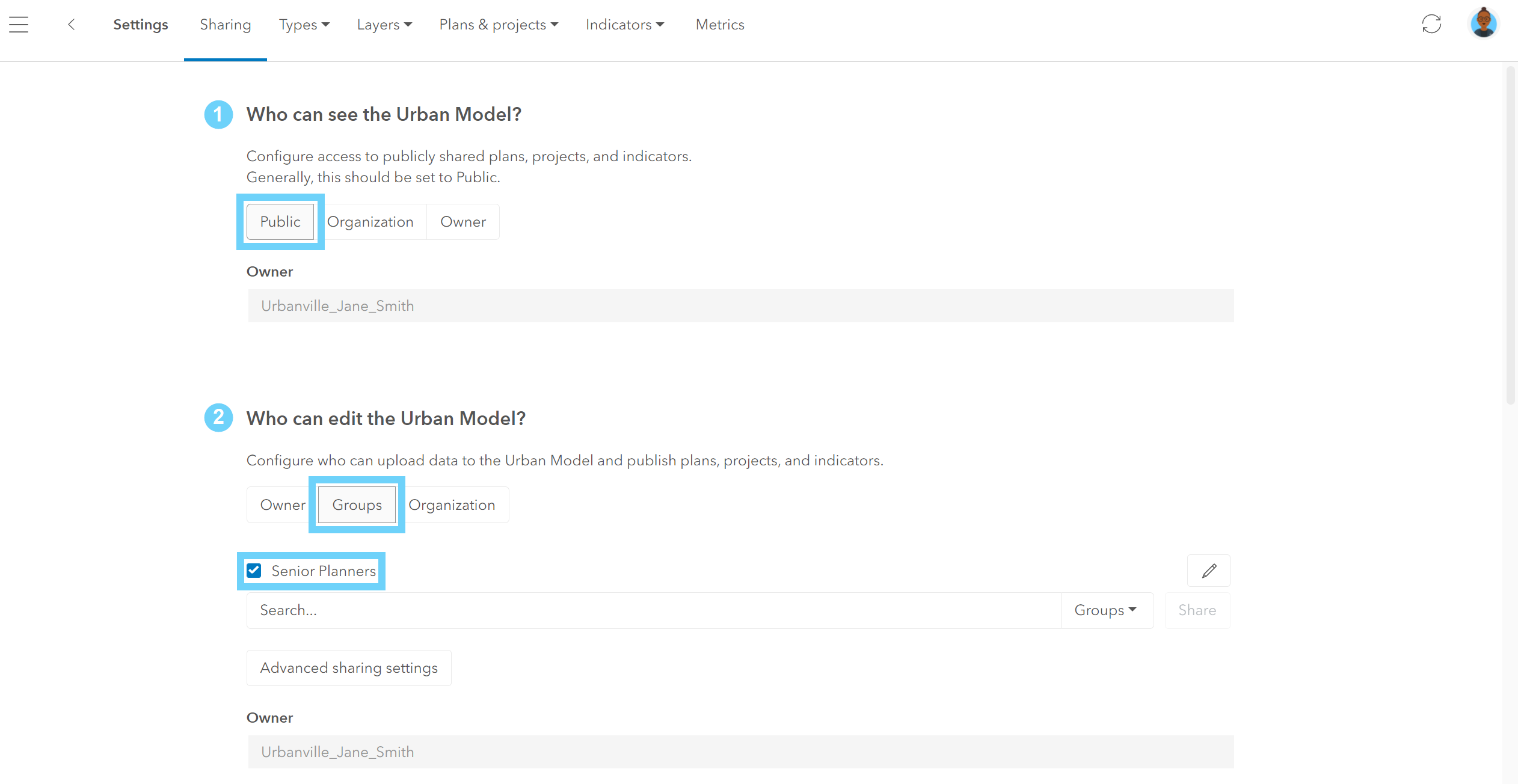
Sharing the Urban Model to accommodate use case 1
Use case 2 – Distinguish public content from design content
Laura, a planner working for the fictional City of Urbanville, copied a project to the public content view. In the list of projects in her content view, she’s now seeing two entries of that project. She is wondering why there is a duplicate and if also the citizens of Urbanville will see it.
Solution:
When a design plan or project is moved to the public content view, a non-editable copy of that plan or project is created. Laura has access to both, the public content view and her own design content view. That’s why in her list of projects she can see both, the original project as well as the non-editable public-content copy of it. A badge on the original project allows Laura to distinguish between the original and the copy. In the design content view, users can also use the content switch to filter the list of plans and projects as well as the map view to display only public content. Users accessing the public content view will only see the non-editable copy.
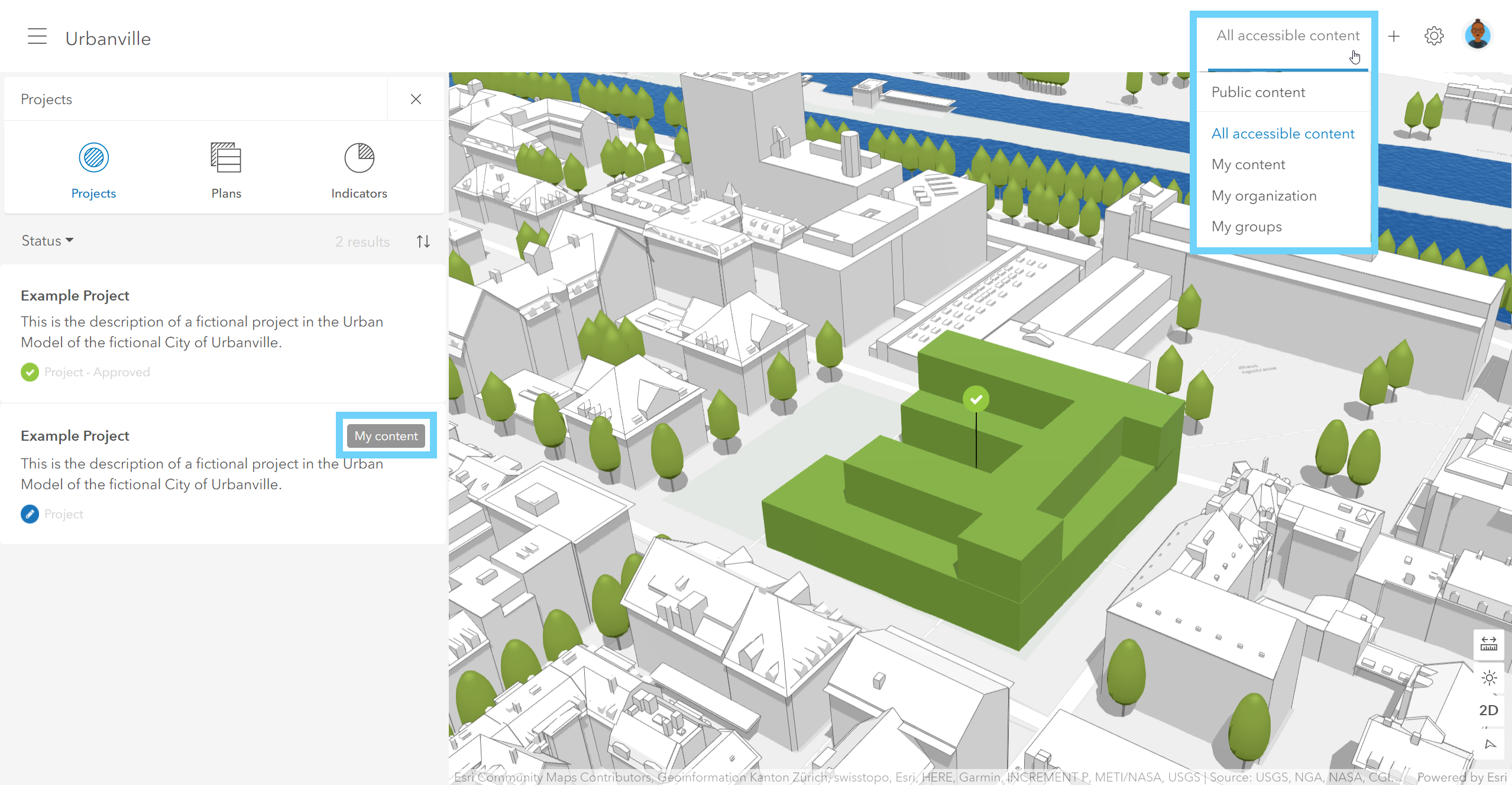
Use the badge and the content switch to distinguish between public content and design content plans and projects
Use case 3 – Incorporate feedback from the public
The citizens of Urbanville provided some very valuable feedback on a public project. Now, the planners would like to incorporate this feedback and adjust some scenarios of that project before sharing the adjusted scenarios again with the public.
Solution:
Scenarios of public content plans and projects cannot be edited. To adjust the project scenarios according to the feedback from the citizens, the planners of Urbanville need to make the changes in the corresponding project. Once the scenarios are updated and ready to be shared with the public, the project itself can be copied again to the public content view. The previously published copy of that project in the public content will be overwritten. Users see a warning message when publishing a project that has already been copied to the public content earlier.
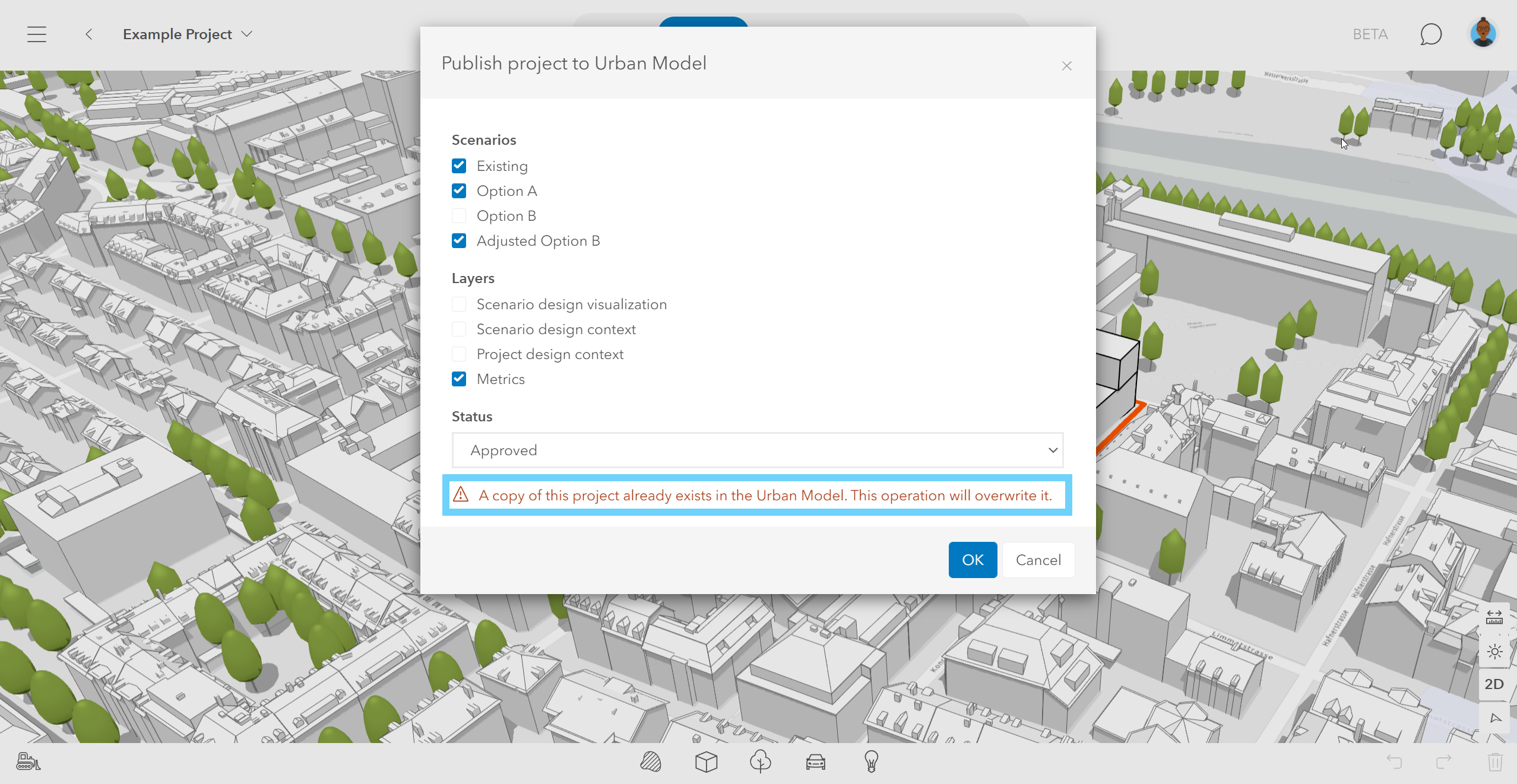
Republishing a project to the public content view
Key Takeaway
Because projects and plans are sometimes meant to be visible to urban planners only, ArcGIS Urban comes with two different views: a public content view and a design content view. The two views not only differ in terms of what data is visible (e.g. plans and projects), but also in terms of available functionality. Three use case examples show how to share an Urban Model and how the public and design content views interact with each other.

Article Discussion: