Overview
Powerful, straightforward and flexible, PinPoint-GIS bridges the gap between accurate and reliable GNSS positioning and GIS functionality at anytime, anywhere on your smartphone.
Septentrio’s GIS solution, PinPoint-GIS, enables you to use Collector for ArcGIS directly with a Septentrio GNSS receiver for rapid, accurate and reliable GIS data collection.
There is no complicated setup: launch the app and connect directly to the Septentrio GNSS receiver. PinPoint-GIS continues to run in the background while Collector uses your preferred workflow. PinPoint-GIS overrides your smartphone location with accurate and reliable GNSS position from your Septentrio receiver notifying you of accuracy decrease and other relevant information.
Quick and easy to set-up for precise and consistent GNSS data, Septentrio’s PinPoint-GIS app features:
- Connection via Bluetooth, Wi-Fi for Altus NR2 or USB for Altus GeoPod
- NTRIP Client for obtaining DGPS/RTK corrections from your smartphone for high accuracy
- Septentrio’s superior GNSS position for all your favourite smartphone apps (Collector for ArcGIS, your own Esri powered app, etc.)
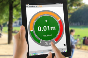
- A unique accuracy widget to customise your accuracy and monitor the quality of your GNSS position
Business needs
Contact provider for more information
Industries
Contact provider for more information
Works with
Contact provider for more information
Platform
Contact provider for more information
System Requirements
- Android 4.0 (Jellybean) or above
- Septentrio GNSS Receiver: Altus NR2 or Altus GeoPod
- Device with developer mock locations support
Version
1.0
Listed Date
Mar 3, 2015
Contact Information
Septentrio NV/SAhttp://www.septentrio.comEmail+3216300800
