Overview
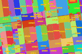
The GeoJunxion ZIP+4 Boundaries represent a boundary file that shares a unique ZIP+4 code in the United States. Typically a
delivery area, such as a city block, office building, individual
high-volume receiver of mail, or any other distinct mail unit. GeoJunxion has
expanded the ZIP+4 code into boundaries based on different data layers
with a proprietary algorithm based on years of experience in map making.
This sample gives an insight in our product. The product is available for all counties in the USA.
Use Case Examples
- Analysis/Direct Marketing
- Building Blocks
- Geocoding
- Online/Local Search
- Route planning
- Sales Territory Management
Business needs
- Asset Tracking and Analysis
- Logistics and Fulfillment
- Supply Chain Digitization
- Field Service Management
- Market and Customer Analysis
Industries
- Public Safety
- Health and Human Services
- Insurance
- Real Estate
- Transportation
Works with
Platform
- Desktop
- On-premises
- Web
System Requirements
ArcMap, ArcGIS Online or comparable software.
Version
2018
Listed Date
Sep 27, 2019
Contact Information
AND Products BVwww.geojunxion.comEmail+31 (0)10 885 1200
