Overview
SOLV3D develops innovative software solutions that enable users to effectively bring together and use in conjunction, various 3D and 2D geospatial datasets, to enhance their existing workflows and modes of operation.
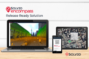
With the SOLV3D encompass™ platform, using only a web-browser, clients are able to easily visualize and share point cloud data, imagery, CAD/GIS models, as well as many other geospatial datasets. The client's data resides in an environment of their choosing, whether an on-premise web server, cloud environment, or accessed through streaming subscription services. ArcGIS Online (AGOL) integration is available to those with a current AGOL account, permitting users to also utilize both their public and private content within the platform.
The result is a robust virtual project setting, providing spatial context and an engaging common operating picture. This environment not only empowers all stakeholders with an enhanced collaboration ability, but also allows them to gain a greater amount of derived value from investments made in their datasets for estimation, planning, design, and decision-making.
Some of the functions within the application include; 2D & 3D measurements, asset tagging & discussion threads, cross sections/profiles, and a unique data export feature (clip, zip & ship).
About Us
SOLV3D is the creator of innovative software solutions for geospatial data processing, visualization and collaboration. The SOLV3D engine™ processing toolkit assists users in optimizing point cloud data for effective use within their applications and workflows. SOLV3D encompass™ provides the ability to merge together a myriad of geospatial datasets in a single platform. Within a web-based environment, it enables all stakeholders to easily gain situational awareness and work together on projects, AOIs and assets, regardless of geographical location or level of technical expertise.
To learn more, please visit solv3d.com
Business needs
Contact provider for more information
Industries
- Transportation
- Public Safety
- Petroleum and Pipeline
- Electric and Gas Utilities
- National Government
Works with
Contact provider for more information
Platform
Contact provider for more information
System Requirements
Supports ArcGIS Online integration.
Version
3.0.2
Listed Date
May 26, 2020
Contact Information
SOLV3D Inc.https://www.solv3d.comEmail+1 (888) 325-1285