Overview
OVERVIEW:
With the continual development of communities, Stakeholder coordination is very important to minimize the conflict while exciting the work. Public/Private infrastructure, utilities assets are shared by different government and private sectors. It’s really required a strong approval process and decision support system to ensure the smooth operations.
The solution eSmartPermit will helps all public/private sectors (Utilities and City Governments) who are providing the No Objection Certificate, Work Permits to the contractors before executing the work. Also this solution framework and intelligent can be used to automate the location based business approval process like example of issuing licenses, building permits, leasing process, Customer Service Management (requesting for Utilities, Transportation, Telecom connection, property registration process, Etc)
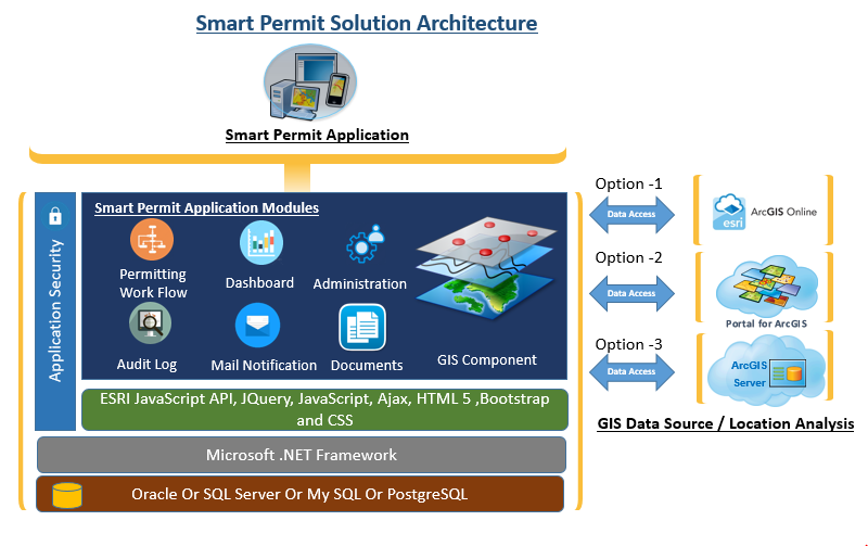
The solution built using latest state of art technologies like ESRI ArcGIS Platform, Microsoft Technologies and the solution can be accessed from web and mobile.
Technology:
Our solution architecture has adopted smart and intelligent techniques, spatial intelligence including domain specific business rules that can accommodate changing operational conditions, intelligent user profiles for different roles and privileges, and comprehensive dashboards for tracking and monitoring of operations and performance.
- eSmart Permit utilizes Esri ArcGIS online Basemaps and business specific web maps (for Permit locations, POI, Buildings, RoW, Easements etc.,) published through ArcGIS online datastore
- The solution can be delivered either On Cloud or On premise utilizing Esri ArcGIS Online and ArcGIS Enterprise capabilities based on customer requirements
- The solution features Active Directory integration, role-based security that can be used for reconfiguring with customer environment.
- The solution can be easily configured to existing business processes by building web services (SOAP) to provide data access based on different Business cases.
eSmart Permit solution can be used across government organizations (Smart Cities), Real Estate or property development, Oil and Gas/Energy sectors, Utility, Environmental, Health, Insurance, Education as well as a variety of high-tech enterprises which involves business process for managing the business operations.

Application Functions:
- Mobile and Web Based application functions
- Fully automated permitting process
- Role-based Dashboards
- Geo location analysis and decision support using ESRI Technology
- Location based risk assessment
- KPI monitoring dashboards and Reports
- Security (Single Sign On, Role Based functions)
- Flexible design easy to integration with other business systems
- Integration with payment gateway
- Inbuilt BPM and document Management
Business Benefits:
eSmart Permit improves operational efficiency and increase your workforce productivity by
- Eliminating risk of manual errors by automating authorizations and workflows
- Providing the insights for automated task management & action tracking
- Creating centralized digital storage & retrieval of all permits
- Maximizing reusability and searchability of forms & templates
- Providing flexible design with easy to integration with other business systems.

Business needs
- Economic Development
- Field Service Management
- Real-Time Location Tracking
- Market and Customer Analysis
- Operational Efficiency
Industries
- National Government
- Electric and Gas Utilities
- Real Estate
- State and Local Government
- Transportation
Works with
Platform
- Desktop
- On-premises
- Mobile
- Web
System Requirements
Operating Systems
- Windows 7 or 10
Supported Web Browsers
- IE 11 (Windows 7 or 10)
- Edge (latest version)
- Chrome (latest version)
Map Support - Esri Map Services
- ArcGIS Server for Windows
- ArcGIS Online
- Portal for ArcGIS
Connectivity
- Internet connection required
- Bandwidth Minimum: 3G
Server Requirements
- Windows Server 2012, 2012 R2, or 2016
- .NET version 4.5 and above
- Multi-core processor 2.0 GHZ or faster
- 8 GB RAM
- For three-tier deployments, the operating system must be the same on both the Web and Application servers.
IIS
- Version 7,8, 8.5, or 10
- SSL SHA-256 is required
Database Support
- MySQL 6.2 and above
- Oracle 11g and above
GIS Integration Support
Options-1: ArcGIS Server REST Services
Options-2: ArcGIS Online REST Services
Options-3: Portal For ArcGIS Web Mapservices
Version
2.0
Listed Date
Apr 7, 2020
Contact Information
iSpatial Techno Solutions Inchttp://www.ispatialtec.com/Email+1 (858) 5229799
