Overview
PLW Modelworks creates industry leading photo-accurate, geolocated 3D City Models from the best quality aerial photography. We deliver data with a high level of accuracy and detail. Our models provide the precise real-world content needed for today’s location-specific tasks.
We can utilize imagery from airplanes, satellites, UAVs, or mobile mapping systems to provide you 3D content that is precise down to the pixel.
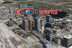
Our model of Downtown Orlando was created from 5 cm GSD aerial imagery. It serves as a demo model for ESRI users to evaluate and experience our models before purchasing a subscription.

Business needs
- Situational Awareness
- Site Analysis and Territory Planning
- Economic Development
- Operational Efficiency
Industries
- National Government
- State and Local Government
- Real Estate
- Public Safety
- Transportation
Platform
- Desktop
- On-premises
- Mobile
- Web
System Requirements
Version
1.0
Listed Date
Aug 22, 2019
Contact Information
PLW Modelworkshttps://plwmodelworks.com/Email321-674-9910
