Overview
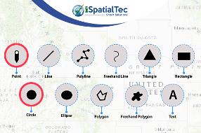
The tool provides sketching and redlining functionality to the map and also has the capability to display measurements if configured for drawn features. For an example, length for lines, area or perimeter for polygons and radius for circles. When the widget initially opens, a dialog box appears and show 11 feature types to draw/sketch. Below are the types:
- Point
- Line
- Polyline
- Freehand Line
- Triangle
- Rectangle
- Freehand Polygon
- Circle
- Text
- Ellipse
- Polygon
The following are the key features of the tool:
- The symbols shown above are configurable. These can be changed or modified using Configuration page and these gets reflected automatically in the e-Draw widget.
- Similarly, multiple point symbols can be configured under Point type feature to add on map.
- Hide/Show favorites symbols.
- Option to clear all or selected symbols on map.
The widget is customizable to implement across various industries such as Energy & Utilities, Oil & Gas, Local Governments, Planning, Community Development, Transportation and Public Safety etc.
Widget is developed in a responsive mode and suits for almost all devices and compatible with all browsers. Technology used to develop this widget is JavaScript API 3.26 and runs on ArcGIS Enterprise 10.5 or above.
For Tool demonstration, please click below URL:
https://widgets.smartgeoapps.com/eDraw-Advanced%20Redlining/index.html#
View the video to see how eDraw - Advanced Redlining works.
For any assistance Contact Us
Connect to www.ispatialtec.com for more information.

Business needs
- Asset Tracking and Analysis
- Field Service Management
- Facility Management
- Site Analysis and Territory Planning
- Market and Customer Analysis
Industries
- Electric and Gas Utilities
- Telecommunications
- Petroleum and Pipeline
- Water
- Transportation
Platform
- Mobile
- Web
System Requirements
Version
2.10
Listed Date
Mar 13, 2020
Contact Information
iSpatial Techno Solutions Inchttp://www.ispatialtec.com/Email+1 (858) 5229799
