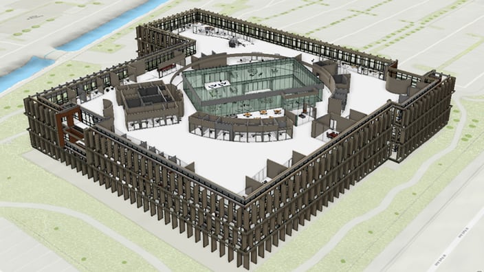
ArcGIS Indoors Pro

Consolidate building data and create indoor maps.

High-angle 3D rendering of a modern building floor plan with brown vertical fins and a central glass atrium.

Empower GIS professionals to map indoors

Create a comprehensive indoor system of record

Indoors Pro extends ArcGIS Pro, enabling GIS experts to become indoor mapmakers. Create and share floor-aware facilities maps, build routable networks, and support digital twins of your buildings. Indoors Pro integrates detailed floor plan data into interactive maps, improving asset and space management, safety and security, and occupant and visitor experiences.

What indoor digital twin use cases can you support with indoor maps?

Previous
Next

Develop a common operating picture of your facilities

Consolidate CAD, BIM, point cloud, and other floor plan data into a single indoor system of record that can be accessed across your organization. 

Make floor-aware 2D maps and 3D scenes to visualize your indoor spaces, people, assets, and points of interest—all in one place. 

3D digital map of a large campus showing buildings as stacked, color-coded floor plans

Improve building operations with floor-aware maps

Create indoor maps for building operations to visualize, analyze, and manage even the most complex indoor environments.

Use these maps to support asset mapping, space management, safety and security, and occupant and visitor experience.

Digital 2D map showing color-coded building floor plans with interactive navigation controls.

Build routable networks to support real-time navigation

Automatically create routable networks from floor plans to support real-time navigation.

These networks support turn-by-turn navigation across multiple floors and buildings, helping people find the most efficient routes to their destinations. Enhance the indoor user experience for building occupants, employees, service providers, and visitors.

3D digital map of a multi-story, cross-shaped building's floor plan displaying numerous rooms and icons for emergency equipment.

Share your indoor digital twin

With Indoors Pro, share your indoor digital twins with visitors, occupants, IT, and facilities staff. Gain a comprehensive view of your facility’s layout and activities to accelerate decision-making, streamline daily operations, and improve emergency preparedness and response.

Angled 3D rendering of a building's gray-walled floor plan with color-coded areas and an interactive navigation panel

ArcGIS Pro

ArcGIS Pro is the premier desktop GIS software. Crafted with user-driven innovations, it offers unparalleled tools and features that support your work as a GIS professional and mapmaker. 

Users can maintain spatial data effectively; generate stunning 2D, 3D, and 4D visualizations; and conduct advanced mapping analytics. The seamless data sharing within the ArcGIS system fosters valuable GIS solutions and insights.

Person working on a laptop in an office with two insets showing detailed maps of a large campus

Contact sales