Documentation
Find answers and information on R-ArcGIS Bridge.


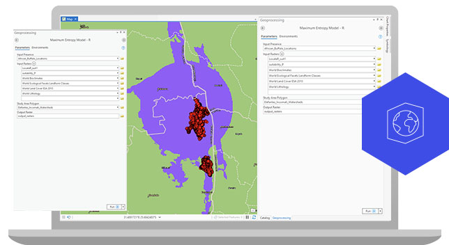
R-ArcGIS Bridge offers you the ability to tap directly into R from your current ArcGIS Pro project, allowing you to meet your analysis needs as they arise.
Get started with these steps:

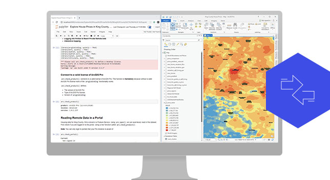
R-ArcGIS Bridge can also be leveraged in Jupyter notebooks, where you can document your analysis by combining code with visuals and text. Get started with these steps:

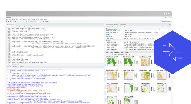
R-ArcGIS Bridge can also be leveraged in RStudio, a popular integrated development environment (IDE) of choice when working with R. Get started with these steps:
You can get R-ArcGIS Bridge with ArcGIS Pro and can leverage it in a multitude of ways, depending on your environment preference. If you are using ArcGIS Pro and already have R installed on your machine, the easiest way to set R-ArcGIS Bridge up is through the R-ArcGIS Integration tab under geoprocessing options. If you are using ArcGIS Pro but do not have R installed and need to have a separate environment for your R analyses, you can create an R environment through Conda Package Manager and the r-arcgis-essentials package.
The R language provides over 15,000 packages that implement both niche analytical packages and general-purpose statistical libraries. With regard to spatial analysis, the R language contains a large number of packages for managing, analyzing, and visualizing spatial data.
Yes, you can deploy script tools driven by R-ArcGIS Bridge as a geoprocessing service within ArcGIS Server. Find detailed steps here - enterprise.arcgis.com/en/server/latest/publish-services/windows/deploying-r-for-arcgis-server.htm
You will need ArcGIS Pro installed with a valid license. You will also need the arcgisbinding package, which can be obtained via the R-ArcGIS Bridge tab within the geoprocessing options in ArcGIS Pro or through Conda Package Manager.
The Microsoft Data Science Virtual Machine (DSVM) comes with ArcGIS Pro. If you have a valid license, you can use R-ArcGIS Bridge in these cloud environments.
Through our Conda integration, we facilitate using the reticulate library to call geoprocessing tools from R. Remember that certain tools require checking out licenses with the CheckOutExtension function of ArcPy, which can also be called from R via the reticulate library.
After data is brought into R via arc.select or arc.raster, you can convert the data into the corresponding R format via arc.data2sf, arc.data2sp, or as.raster functions. After the conversion, full dplyr functionality is available on the spatial dataset.
Commonly used environment settings include Workspace, which controls the default location for geoprocessing tool inputs and outputs. R-ArcGIS Bridge can work with other environment settings, as detailed in this link: pro.arcgis.com/en/pro-app/help/analysis/geoprocessing/basics/geoprocessing-environment-settings.htm
Jump-start your spatial data science journey with these R-ArcGIS Bridge resources.
Begin a conversation online.
Speak with a representative.