Skip to Content
ArcGIS Workforce

ArcGIS Workforce

Smarter field workforce coordination at your fingertips

A graphic of a laptop screen and a mobile phone displaying coordinating street maps against a plain white background

ArcGIS Workforce is a mobile app solution that uses the power of location to coordinate your field workforce. It integrates work management to reduce reliance on paper and provides everyone with access to the authoritative data they need. ArcGIS Workforce is designed to help you reduce errors, boost productivity, and save money.


What Workforce can do for you

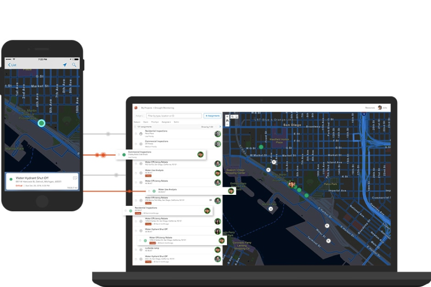
A full picture of productivity

A common view from the field and the back office makes the right things happen. The right worker goes to the right place with the right tools to do the right job. And, because everyone is working from the same right data, you avoid costly errors and inefficiencies.

Real-time awareness

Gain insight from the office into field activities so you are always aware of the status of fieldwork. When priorities change due to unanticipated events, you are ready to respond. You have a clear view of task priorities and field crew locations to get things quickly back on track.

Greater efficiency

When you streamline the process of managing and assigning field work, it saves time for everyone. Fieldwork projects are created and distributed into discrete assignments. Then, fieldworkers receive and report on assignments through smart devices.

Smart devices, smart workers

Fieldworkers carry their maps and assignments on smartphones or tablets, making it easy and convenient for them to stay organized, report progress, call for assistance, and stay productive. Say ‘goodbye’ to those paper-based processes that caused too many errors and inefficiencies.

Improved reliability

Surpass expectations and build trust with your customers through improved reliability and consistency in the completion of fieldwork. Effective project management, with real-time insight into field activities, gives you the power to meet service commitments.

How Workforce works

CASE STUDY

Meter inspections and replacements

Utilities Kingston manages meter inspections and replacements more quickly, safely, and efficiently using ArcGIS Workforce.

Read the case study

Better together

Use these focused ArcGIS apps in combination with ArcGIS Workforce to maximize efficiency in your field workforce.

View field mobility solutions
ArcGIS Navigator

ArcGIS Navigator

Get precise directions to work sites, even on private roads. Save time and money by using optimized routes.

Learn more about ArcGIS Navigator
ArcGIS Field Maps

ArcGIS Field Maps

Mobile workers can select tasks from To Do lists in Workforce, launch this mapcentric app to collect and update data at work sites, then easily return to Workforce once tasks are completed.

Learn about ArcGIS Field Maps
ArcGIS Survey123

ArcGIS Survey123

Complete field data collection using this form-centric app. It fits the needs of field personnel in diverse environments.

Learn more about ArcGIS Survey123
ArcGIS Dashboards

ArcGIS Dashboards

A real-time dashboard allows you to make decisions at a glance by monitoring, tracking, and assessing field activities.

Learn more about ArcGIS Dashboards

Workforce is fully integrated with ArcGIS

Combined with other ArcGIS apps, you can maximize efficiency in your field workforce and get the flexibility you need to run in the cloud or in your own IT infrastructure.

Learn more about ArcGIS