Drones, AI Support Humanitarian Aid at a Bangladesh Refugee Camp
Key takeaway
This story details humanitarian efforts at a refugee camp in Bangladesh, where dramatic population growth heightened flood, landslide, and health risks. Using drone imagery, geographic information system (GIS) technology, and artificial intelligence (AI), administrators collected data about camp conditions and established improvement plans to keep refugees safe and maintain sanitization.
Solving our most complex problems, from environmental risks to social issues, can begin in the sky. Drones capture comprehensive views and inspire new ideas we can easily miss from the ground. And today’s machine learning and artificial intelligence (AI) capabilities help us extend the value of drone imagery, enabling us to predict what the future may hold so we can effectively prepare.
As a Muslim minority group in a predominantly Buddhist country, the Rohingya people have endured decades of ethnic and religious persecution. In August 2017, Burmese security forces launched massive attacks on predominantly Rohingya areas of Myanmar. In one of the largest forced migrations in modern history, hundreds of thousands of Rohingya people left their homes and crossed the border to Bangladesh. Many made their way to the Kutupalong Balukhali camp in an area known as Cox’s Bazar. Within weeks, the population of Kutupalong and nearby camps ballooned to 500,000. It became one of the world’s most densely packed refugee camps.
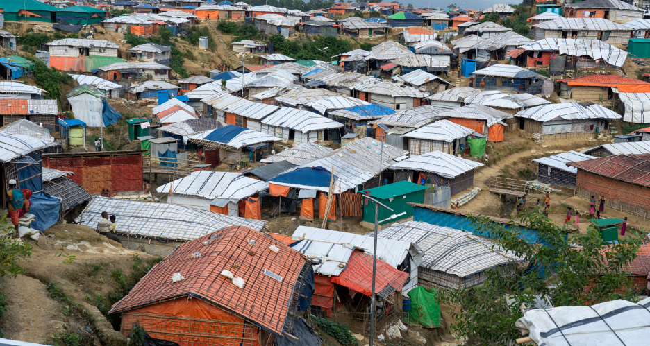 Kutupalong refugee camp is the world's largest refugee camp with around 600,000 people.
The population increase created enormous logistic challenges for the International Organization for Migration (IOM), which works with the Bangladeshi government and UNHCR to administer the camps. Nearly one-third of the camp—including one-quarter of its latrines and nearly half of its hand pumps for water—is at risk for floods and landslides during the rainy season. Heavier rainfall also correlates with increased health risks.
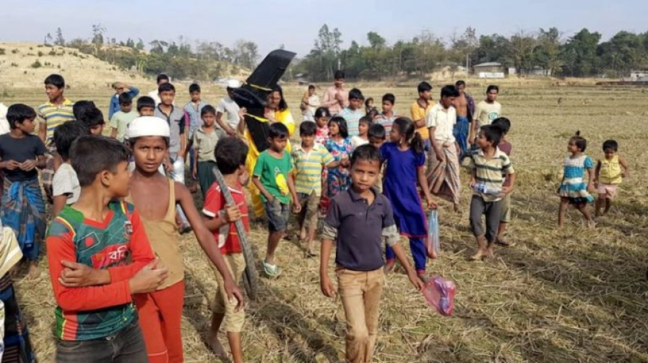 Use of the drone creates a community event, with young people particularly interested.
Administrators also wanted to ensure that the camp met global Sustainable Development Goals (SDGs), specifically Goal 6: Ensure availability and sustainable management of water and sanitation for all.
Using drones to map the unmappable
For IOM and Bangladeshi government workers, the overarching need was to visualize the camp’s extent to better help the people there and maintain sanitary conditions. Getting a sense of how—and how many—people were transforming Kutupalong camp could help answer questions about how to accommodate them.
Administrators utilized the power of imagery, deep learning, hydrology, and network analysis to empower understanding of the camp facilities. They identified four basic questions that drone mapping and analysis could help answer:
- What percentage of the refugee camp does not have access to a washroom within a 2.5-minute walk time?
- Do different types of analysis (network analysis, coverage-based analysis) give significantly different results for the above question?
- What percentage of the population lives in the most at-risk areas for floods and landslides?
- How many washrooms and latrines are located within these critical areas?
Imagery analysis helps measure the population and risks
First, administrators identified what datasets were available and which of those would be most useful in helping to answer the questions.
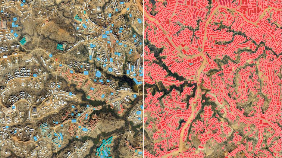 The team used deep learning to identify tents in the refugee camp.
To understand the population, they used drone imagery and an available deep learning package hosted by Esri’s ArcGIS Living Atlas of the World. They utilized drone imagery to get the footprints of tents and structures built in the camps. They were able to retrain the AI tools within ArcGIS—Esri’s geographic information system (GIS) technology—to improve the relevance and accuracy of results. From the information and metrics on population density and washroom usage, shared from the United Nations High Commissioner for Refugees (UNHCR), they were able to find the answers to their questions:
- Approximately 1.8 percent of the population does not have access to a washroom within a 2.5-minute walk time, and 24 percent of the population has greater than a 1-minute walk time.
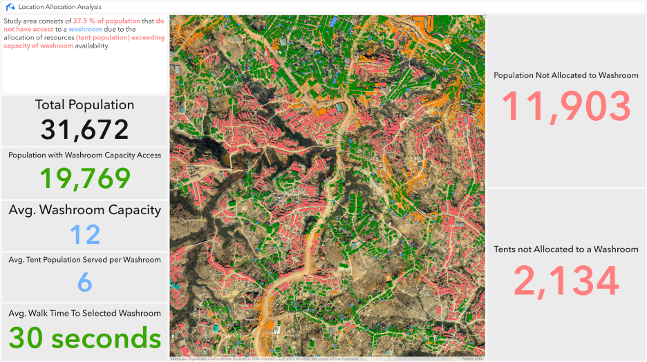 A dashboard was created to monitor the percentage of the population in the refugee camp that did not have access to a washroom within a 2.5-minute walk time based on network analysis.
- Coverage analysis provides a comparable result as network analysis. This approach can help augment an analysis where no road network dataset is available.
- Approximately 27 percent of the population is located within the most at-risk areas for floods and landslides.
- Approximately 104 latrines and 45 washrooms are located within the most at-risk areas for floods and landslides.
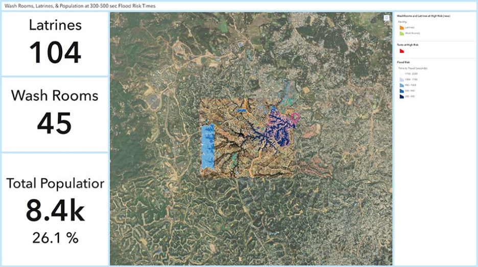 A dashboard shows washrooms and latrines that are in high flood-risk areas.
Extending AI tools for comprehensive imagery data
AI was also used when mapping the camp to augment GIS data. AI gives GIS the ability to process complex imagery automatically and quickly. The drone imagery—combined with map data from OpenStreetMap and other partners—could be programmed to recognize and categorize geographic features, including buildings, human-made objects, vegetation, and soil. (To alleviate privacy concerns, the drone is flown at an altitude too high to capture recognizable images of individuals.) These rich images give camp administrators a comprehensive view of the area’s ad hoc structure. This information becomes part of the GIS database, which lets relief workers visualize the density of a block.
The combination of drone imagery, GIS, and AI also helps workers understand the land the camp occupies. An influx this large involves massive environmental upheaval. Removing all the human construction from the map leaves just the ground surface, providing a digital terrain model that can be used to calculate landslide risk and flood modeling.
Beyond mapping the camp and helping site planning and development, the use of imagery and GIS for Kutupalong provided a platform for a broad range of data. With mobile devices, relief workers from UNICEF and other agencies can access various cloud-based datasets, getting the information needed to do their important work.
The estimated population of Kutupalong Balukhali and satellite camps that have formed around it now hovers around 900,000. As ongoing drone flights provide bird’s-eye views of the camp, the new data provides ground-level context. The result is a living digital document that evolves with the camp, giving relief workers actionable insight to help improve conditions for refugees.
Gathering and analyzing multilayered data with drones and AI has far-reaching impacts. These practices can help us better understand geographic areas so we can be better stewards of the earth and protect the people who depend on its resources. We also set ourselves up with a foundation for learning year over year so that we can work toward solving our most complex problems.
 A dashboard shows the results of location allocation analysis.
Need help finding the right solution?
Schedule a conversation with one of our experienced sales consultants. Tell us how you're using imagery and remote sensing data now, and we'll show you where a comprehensive geospatial system can take your work next.