
Map and analyze your business data with ArcGIS
Embed location into core business functions to drive growth, efficiency, and security.
Market leaders everywhere choose ArcGIS
-
-

of the world’s largest companies
-

partner organizations globally
Previous
Next
Answer essential questions at a glance
ArcGIS includes ready-to-use analytics and data so you can get started quickly.
- Choose the right location
- Find the best route
- Adapt to demand
- Stay ahead of risks
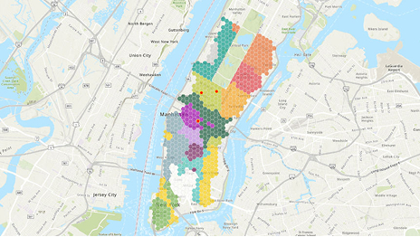
Where is the best place to expand into promising new markets?
To choose locations that strengthen your bottom line, enrich your business intelligence—like sales trends and customer habits—with ArcGIS data:
- Competitors: See locations, industries, and sales for over 13 million businesses
- Demographics: Select from 2,000+ features like income, age, education, and more
- Market segmentation: Explore 67 lifestyle and behavior groups by neighborhood
In this map, an entertainment company uses ArcGIS to score potential sites for a new theater based on facility characteristics and demographics.
Where can we optimize delivery networks?
To design routes that advance your priorities—like speed, distance traveled, fuel efficiency, or safety—link your business data about facilities and fleets to ArcGIS data:
- Global traffic: See historic and near real-time traffic data in the US and worldwide
- Precise basemaps: Plan routes with total coverage of streets and points of interest
- Weather: Assess likelihood of delays from storms and related road hazards
In this map, a logistics company uses ArcGIS to plan deliveries from a distribution center to customers, while avoiding construction and minimizing drive time.
Where can we tailor services to increase sales?
To match inventories to local demand, staff efficiently, and optimize pricing, pair your data—employee stats, top products, customer spending—with ArcGIS data:
- Consumer trends: Explore expenditures by households for 20+ categories
- Market potential: Understand consumer demand for thousands of product types
- Human movement: Find aggregate data about commute time, visits, and dwell time
In this map, a grocery store chain uses ArcGIS to understand where customers shop, how much they spend, and what they buy.
Where will risks, threats, and emergencies impact operations?
To protect people and property, maintain continuity, and stay compliant, contextualize your data—real estate, high-value assets, employees—with ArcGIS data:
- Weather patterns: Assess likelihood of hurricanes, floods, fires, or other natural threats
- Crime statistics: Understand crime patterns near your current or potential facilities
- Emergency facilities: Find hospitals, police stations, and other crisis centers nearby
In this map, a business uses ArcGIS to visualize impending weather near key assets and flag facilities at risk of storm damage.
Find breakthrough insights competitors miss
With AI-enriched mapping and analytics in ArcGIS, you can uncover patterns and efficiencies that conventional tools can’t detect.
Previous
Next
ArcGIS integrates with your everyday tools
Make everyone—from executives to frontline workers—better problem solvers. Bring AI-enhanced mapping and analytics to the systems and databases you already use.

Previous
Next
Businesses gain advantages from ArcGIS—fast
These innovators know that mapping and analytics mean the difference between leading the market and following it.
-

Marriott maps threats to safeguard assets
A real-time risk assessment tool helps teams visualize threats, share intel, and act quickly to protect guests and operations.
-

FedEx keeps planes—and promises—on schedule
A live operational map tracks planes, parts, and mechanics to ensure on-time delivery and customer satisfaction.
-
RIPCO Real Estate guides big brand decisions
Aligning property and market data with demographics, brokers help Chipotle, Target, and others expand confidently.
Previous
Next
Discover what ArcGIS can do for your business
Tell us about your organization. An expert will reach out to discuss the right mapping and analytics solutions for you.