USER STORY
Spatial Analytics and Data Diminish Tree-Related Outages 60 Percent
Mid-South Synergy removes tree hazards as part of its normal electric operations. Historically, crews patrolled all facilities and used customer calls to also identify problem areas. Changing conditions necessitated more sophisticated methods. The utility used state-of-the-art geographic information system (GIS) technology and data to improve its effectiveness. This approach enhances public safety and prevents power outages.
The Challenge
The utility's 3,000 miles of electric distribution lines partially overlay the Sam Houston National Forest. Historically, 30 percent of Mid-South Synergy's electric outages were due to fallen trees and branches and vegetation encroachment. A severe drought killed many trees, which subsequently fell on electric lines. Falling, dead trees quickly became the leading cause of electric service outages. Despite appropriate right-of-way maintenance, dead trees outside the company's right-of-way escalated to cause 90 percent of tree incidents.
Industry - Electric & Gas
User
Mid-South Synergy cooperative provides electric service to 23,000 customers across six Texas counties
Challenge
Falling, dead trees caused power outages and damage
Solutions
Use ArcGIS Spatial Analyst to determine risk by area and focus tree removals
Results
- Reduced customer tree complaints by 90 percent
- Dropped tree-related outages by more than 60 percent
- Reduced employee overtime
The Solution
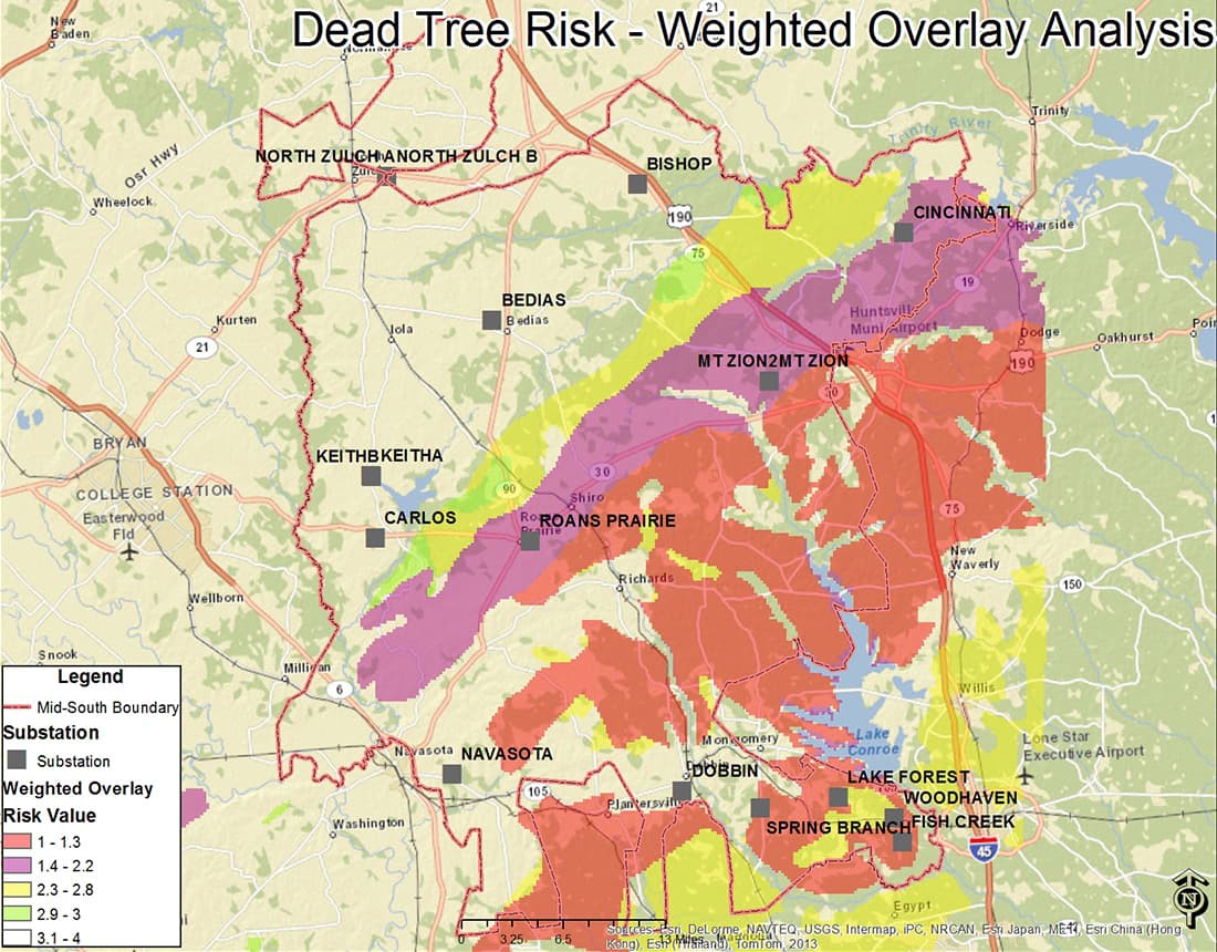
Mid-South Synergy uses Esri's ArcGIS software as a system of record and an asset management tool. Utility staff applied the powerful spatial analysis capabilities of the ArcGIS platform to gain insight into their tree problem. Consuming free US Geological Survey (USGS) soil and vegetation map layer data into their GIS helped them identify the areas of greatest risk. They found that tall pine trees in dry soil types posed the greatest hazard to their wires. Using this data, ArcGIS Spatial Analyst determined the probability of dead trees falling on the utility's electric wires across the territory.
The staff categorized the entire service area by risk level. With a solid grasp on risk, utility staff focused on removing dead trees in high-risk areas to reduce power outages. The utility used location information from both the data analysis and specific customer reports to consolidate tree trimming work increasing operational efficiency.

The Results
The new GIS-enabled workflow prioritized work for crews based on the risk of falling trees. In the first year, customer complaints about trees dropped by over 90 percent, from 800 per month to less than 100. Proactively addressing high-risk areas eliminated the need to wait for customer calls before taking corrective action. The number of tree-related outages dropped by more than 60 percent.
Dead trees are now removed on a planned basis before they create an urgent problem. This is safer, more convenient, and cost-effective. By removing most of the hazardous trees, Mid-South Synergy reduced overtime costs significantly. By using ArcGIS and grouping the tasks spatially, the utility increased the annual removal of hazardous trees from 2,600 to 23,000 in just two years. This improvement increased customer satisfaction, enhanced safety, and boosted system reliability substantially.
"GIS is not just about maps. Spatial data analysis solves real business problems."
Comfort Manyame, PhD, GISP
Senior Manager, Data & Business Intelligence
Mid-South Synergy