Skip to Content

Infrastructure Protection and Critical Incident Management

Protect key assets, manage critical incidents, and secure special events

Area of operation map and two people dressed in fatigues

Strengthen security operations

Protecting critical infrastructure and managing large-scale events are of paramount importance to the security and stability of communities around the world. GIS supports security mapping for critical events, analytics to support operations planning, real-time monitoring, and risk management for any event—planned or unplanned.

Capabilities for infrastructure and critical event management

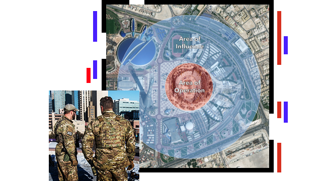
Understand your area of operation

Understanding your area of operation (AO) means being able to define and protect a specific geography such as a facility, a campus, or even a large city. Use ArcGIS to collect, integrate, map, and visualize foundational or sensor data, imagery, and demographics for complete situational awareness of your AO.

Suspicious activity alert in an urban area

Conduct critical event planning

Develop configurable event-planning solutions to help incident commanders build and maintain a security plan for any scenario, planned or unplanned. Easy-to-use editing features help planners build tactical plans and modify them in real time as conditions change during an event, ensuring that everyone has complete operational awareness.

People in black protective gear

Integrate third-party solutions & data feeds

Capture and manage multi-intelligence data sources from records management systems, CAD-911, social media providers, meteorological feeds, DHS HIFLD, CCTV, border sensors, AIS, drones, and other government and private sources of information. Filter and focus data using viewers and dashboards that are user defined and mission specific.

Incident map

Identify vulnerabilities and manage risk

Collect and integrate information for rapid analysis to identify threat patterns and relationships. Gain insight into threats and hazards by fusing incident and intelligence data that can improve vulnerability assessments and help safeguard communities and critical infrastructure.

Map with area of concern in yellow

Understand your operational environment

ArcGIS serves content to virtually any device, providing flexible access and visualization in one common operational technology. Establish shared awareness, integrating data from multiple sources and agencies with advanced maps and spatial analysis.

Person in combat uniform looking at a digital map

User Story

San Antonio gains real-time awareness

A real-time common operational picture heightened awareness and aided rapid response for Final Four security.

Read the story

Products and ArcGIS Solutions

Previous
Next

Contact sales

Contact us

Outside the United States

Connect with the Esri public safety team