CASE STUDY
Data Visualization and Analysis Save SD1 over $2.5 Million
Sanitation District No. 1 (SD1) began as a small wastewater treatment utility serving the river cities in Campbell and Kenton Counties. Today, SD1 manages the region's storm water and is the second largest wastewater utility in Kentucky. SD1 serves over 30 Northern Kentucky local governments within Boone, Campbell, and Kenton Counties, providing services to 300,000 residents. SD1's storm water services cover 218 square miles and include 430 miles of storm sewers and over 30,000 structures.
Challenge
SD1 had established a maintenance program using Probability of Failure (POF) and Consequence of Failure (COF) to calculate a Business Risk Evaluation (BRE) score for each publicly owned asset. This program revealed that not all assets fit the definition of a Municipal Separate Storm Sewer System (Ms4). Because each city within Northern Kentucky had its own ideas on which storm system it actually owned or maintained, a detailed analysis was needed.
Solution
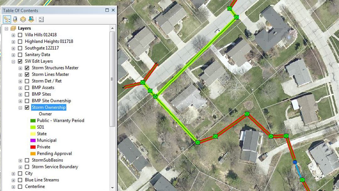
SD1 implemented Esri's ArcGIS software. Assets from each city were identified and visualized within ArcGIS Desktop. ModelBuilder was used to automate workflows to make this work more efficient. Using detailed maps, SD1 met with each city to review and finalize ownership of all assets. Using analytics, SD1 was able to identify work orders assigned to nonpublic pipes, resulting in cost savings for each city.
GIS allows SD1 to easily communicate detailed geospatial analysis with surrounding cities and counties, resulting in a high level of accuracy, saving SD1's customers over $2.5 million.
Jordan Hamm, GIS Coordinator, SD1

Map showing ownership of storm sewer and associated structures.
Results
SD1 was able to remove $2.6 million worth of scheduled work from its current plans. And long-term, the District is no longer responsible for operation and maintenance of 47.5 miles of storm sewer and associated structures with a total asset value of over $30 million. 250,000+ feet of previously public assets have been confirmed as not being a part of the Ms4. Implementing ArcGIS enabled more efficient workflows, accurate representation of assets, and strong analytics. An authoritative and accurate system of record increased confidence in decision making resulting in improved management of assets. Using ArcGIS technology has resulted in cost saving measures for SD1, their rate payers, and more efficient use of available funds to further improve northern Kentucky’s storm sewer system.