CASE STUDY
Modernizing Preventative Maintenance with ArcGIS
To maintain district sewer mains, Silver Lake Water and Sewer District crews regularly clean them using a high-pressure water jetting nozzle. While all mains require cleaning, certain mains need it more frequently due to a lack of sufficient pipe slope, pipe damage, unusual sewage flows, or other reasons. Staff assigned to clean the sewer mains must stay on schedule to clean all pipes and, at the same time, clean problem mains more frequently.
Industry: Water Distribution
User: Silver Lake Water and Sewer District
Challenge: Move from a paper-based system to a digital solution
Solutions: ArcGIS Collector and ArcGIS Web AppBuilder
Results: Hours of time saved; more reliable, easily accessible data
The Challenge
A large paper map was being used to track the sewer cleaning work. As the sewer mains were cleaned, they were highlighted on the map, listed at the bottom of the map, and put into a spreadsheet. Once a year, the data was entered into the geographic Information system (GIS) and a new map was printed. This was a manual process that often resulted in duplicated efforts because crews either couldn’t remember whether the line needed to be cleaned when they were out in the field or skipped cleaning a line because they thought it had been done. In the field, crews were using map books that could become out-of-date. In the past, when crews found something in the field that didn’t match the map book, they could spend up to half a day researching as-builts back at headquarters, trying to figure out what was going on. A new system was needed to enable the crews to work efficiently and share their work across their organization.

“Using the Collector application makes keeping track of work so much easier than the paper process. We can mark our work as we do it, and it is much easier to review the work we have done.” - Jeff Enns Maintenance Worker
The Solution
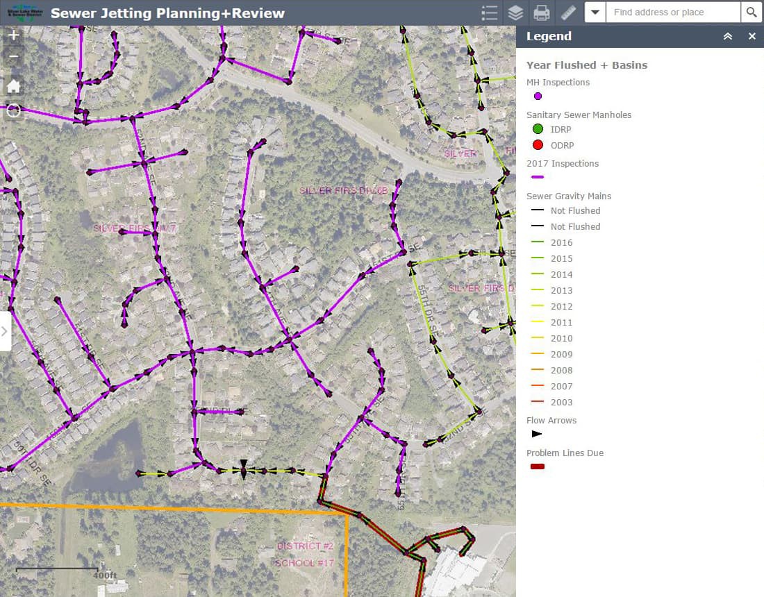
ArcGIS Collector was configured for the crews to maintain current records of their work, including photos. This allows them to easily see which mains and manholes are due for inspection and provides access to asset information such as pipe diameter, length, and date of last inspection. This also provides a means to note comments associated with the cleaning, which helps the GIS staff improve records of the infrastructure. ArcGIS Web AppBuilder was used to create an application that enables crews and their supervisors to monitor and plan daily work. The application includes the same information as the ArcGIS Collector configuration and adds the ability to filter inspection results to easily review the work being completed. This is useful for determining whether to clean a line again if it has had trouble in the past or, if there is a sewer backup, to determine how long since the last cleaning it has taken for a blockage to build up. Also, it is easier for the supervisors to see how work is progressing.
The Results
Implementing ArcGIS Collector and configuring the web application have saved the field crews hours of time by eliminating the need to bring paper reports from the field back to the office, update the paper map, and then update the spreadsheet. Record keeping has been dramatically improved, and by providing an easy way to view status of the work being completed, daily work is more efficiently assigned.
Optimize Your Field Operations
Improve Operations with Streamlined Workflows