USER STORY
Prince George's County Saves Time and Money with ArcGIS
The Board of License Commissioners (BLC) is responsible for managing and inspecting all liquor license establishments within Prince George's County, Maryland a suburb of Washington, DC. BLC wanted to reduce costs by streamlining the inspection process and simplifying inspection data management. To solve the problem, BLC worked with the county geographic information system (GIS) department to deliver an integrated suite of web-based apps that eliminated costly paper work processing and increased efficiency by 65 percent.
Challenge
Previously, BLC inspectors used paper-based surveys to review and evaluate the license status of every liquor store in the county. While the inspections themselves weren't complicated, managing the data associated with the inspections had become costly and inefficient.
Inspectors used paper maps to find locations and recorded inspection notes on paper forms. But handwriting the establishment's ID number and other information propagated errors in the data. The inspectors used digital cameras to photograph both the properties and the forms to keep the information organized. At the end of the day, they'd turn in the surveys and photos, which would be manually entered into a computer system, usually at night, taking about 30 minutes per survey.
Not only was this process inefficient, but on average, only about 70 percent of the surveys were entered each night, which meant that the remaining surveys were added to the next day's workload, creating an endless backlog. Over the course of a year, this backlog would amass an additional four weeks of data entry work. To make matters worse, the paper survey forms were archived in boxes and stored in a room, which made it difficult to find and review past inspection information and caused inspection deadlines to be missed.
The process of assigning inspections and reporting the results was also problematic. Tasks were assigned via email, and reports had to be assembled manually. Inspectors were spending hundreds of hours each year managing the data and photos. Often, inspectors were unable to complete their reports until days after the inspection.
BLC realized that the entire inspection process needed to be revamped.
With the use of ArcGIS, BLC is able to save time and money while being more efficient and communicative with its stakeholders.
Solution
BLC asked Prince George's County GIS department for a more efficient and less costly solution.
First, the GIS department used Esri's ArcGIS to map the location of every establishment in the county that had a liquor license. Next, staff used a combination of ArcGIS configurable applications to enable mobile data collection and automate reporting.
Using iPads, inspectors receive assignments from supervisors via Workforce for ArcGIS. The Workforce app streamlines the process of managing and assigning fieldwork and allows inspectors to have all their maps and assignments on one mobile device. Inspectors use the app to complete to-do lists while supervisors track progress.
For data collection, the inspectors use Survey123 for ArcGIS. Survey123 is a form centric app for creating, sharing, and analyzing surveys. In this case, the GIS department created smart forms for each type of inspection, with predefined questions based on logic, which makes filling in the answers an easy and intuitive process. Inspectors use the iPad camera to capture photos. Completed surveys and associated photos are uploaded to ArcGIS, fully organized.
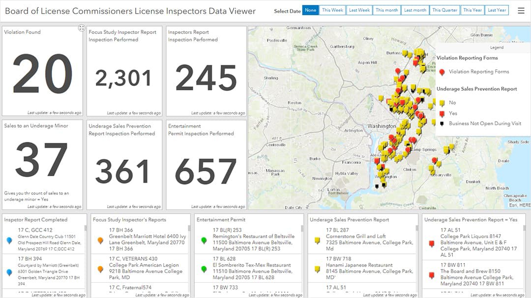
Back in the office, supervisors use Operations Dashboard for ArcGIS. The dashboard provides a real-time operational view of what inspectors are doing in the field and allows supervisors to monitor key performance indicators, such as the number and locations of completed inspections. BLC supervisors also use Operations Dashboard to generate weekly and monthly reports of all inspections.

Results
With a revamped and modern inspection process based on ArcGIS, BLC is seeing significant cost and time savings. Surveys are loaded automatically into ArcGIS, eliminating the manual data entry workflow and backlog. It's no longer necessary to archive and store paper surveys—plus BLC now has a usable storeroom.
The inspection process is more efficient, too. Inspectors complete 65 percent more inspections a day and have cut in half the time needed to finalize a survey. All the maps and tools are encapsulated in one, lightweight device.
The new process has also introduced flexibility into the daily work experience. If an inspector's tasks are all completed early, a supervisor can commit or reassign tasks based on workloads.
BLC is planning on adding ArcGIS Navigator to the inspection process. Navigator provides optimized routes to the next assignment with turn-by-turn directions, which will reduce fuel costs and the time spent between assignments.
ArcGIS has shown how, in the future, GIS could change BLC business practices—with digital automated forms and efficient workload management for inspectors and their supervisors.