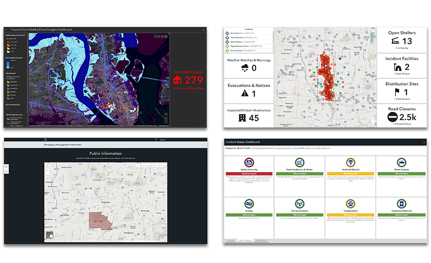
Skip to Content

Emergency Management Operations

Real-time solutions to modernize your response operations

Contact sales

Situational awareness for any incident

Esri's solution for emergency management operations is a fully integrated system that allows you, your team, and unlimited partner agencies to maintain shared situational awareness at all points during a response.

Watch the video

Your modern Emergency Operations Center

previous
Next

Esri’s Solution for Emergency Management Operations

A full suite of response applications designed to help you maintain real-time situational awareness.

Situational Awareness

Ensure personnel have full visibility into rapidly changing events. Anticipate how to adjust your plan in real time to address any situation.

Damage Assessment

Respond faster with a live mobile app for Android or iOS and track real-time progress using the connected dashboard to monitor reporting thresholds.

Impact Analysis

Assess potential impact with a click. See demographics and infrastructure that might be affected by a new forecast or within an area of interest.

Incident Briefing

A comprehensive, real-time incident briefing combines critical information in one place, so decision-makers can make faster, smarter decisions.

Public Information Map

Scalable, public-facing maps provide vital incident information to help your community clearly understand their risk and get to safety.

Deploy with confidence

Esri’s solution for Emergency Management operations is available as a complete bundle that includes all the software, apps, content, and services you need to get started. Reduce the burden on your staff and modernize your agency in five days with our subject matter experts.

Ready-to-use content

Esri's ArcGIS Living Atlas of the World provides data from around the globe to help you make real-time decisions and stay informed during rapidly changing conditions.

ArcGIS Solutions

Configurable maps and apps transform Esri's core applications into mission-specific tools that help you solve the most common challenges in daily and incident operations.

ArcGIS software

ArcGIS is the heart of the Esri Geospatial Cloud. Gain insights using tools to visualize and analyze your data. Collaborate and share via maps, apps, dashboards, and reports.

Subject matter expertise

Esri will quickly deploy the solution on-site at your agency in one week and transfer all the knowledge needed to ensure your team is up and running for the next incident.

Contact sales

Get started with your modern emergency management operations today.