ESRI'S SOLUTION FOR EMERGENCY MANAGEMENT OPERATIONS
Manage the Flow of Public Information
In times of crisis, the swift dissemination of accurate information to individuals at risk is crucial to minimize injury and loss of life. Citizens need effective and timely communication of current personal risks:
- where avoidable hazards are located,
- when it is time to evacuate, and
- where to go when evacuation occurs.
The most common past methods of sending out updates and evacuation information has been via standard media outlets and door-to-door interaction; however, this has not been an effective way to ensure individuals are receiving the critical information they need to gain awareness of their personal risk levels and decide how they will proceed.
Information without context is difficult to navigate
It is difficult for citizens to filter through data-packed and text-heavy updates; they need context to figure out which pieces of information are relevant for them based on their location. Esri’s detailed digital maps can help you present your critical updates in the context of location, by showing citizens in an easy-to-grasp format where they can find existing hazards, risk areas, safety zones, and evacuation routes.
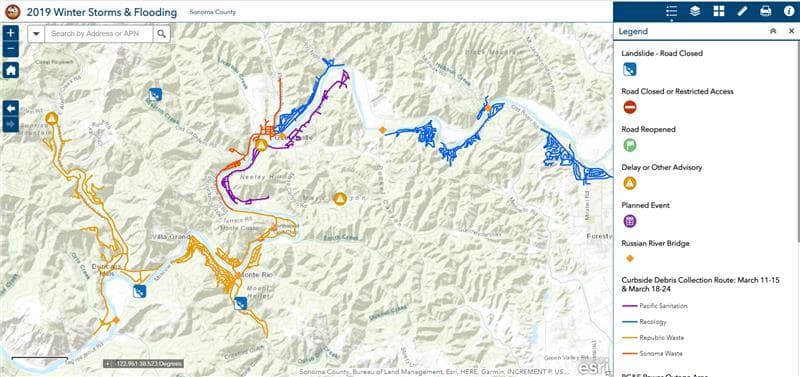
After flooding in winter 2019, Sonoma County provided citizens with detailed, contextual information on road closures and openings, existing landslides, and clean-up operations that may cause delays in travel.

Website instability can cause delayed and false information to be publicized
Another typical way for command staff to quickly circulate important updates is to post the information on the organization’s website; however, during an incident, the server may experience such an overwhelming number of individuals accessing the data at the same time, that it is unable to cope with the load. The server becomes slow or entirely unresponsive, and eventually, the website crashes. This leaves at-risk citizens and information-starved media with no source for crucial updates and communication with your staff. Your authoritative voice is lost when it is most needed. In the age of social media, you need to plan on your website going viral during an emergency. Esri’s solution for public information ensures that your maps can scale to the demand that may suddenly occur in a crisis event, keeping your updates accessible to the public at all times.
Public information accessible from anywhere
Esri’s technology applies your approved public information message across all platforms instantly and automatically, cutting down on labor and time needed to get up-to-the-minute updates to the public and media when they need it most. Esri takes the information that you need to share and makes it available to everyone, anytime, no matter where they are. Individuals have the same access to your updates whether they are in their house using a computer or away from home with a phone or tablet. This versatility becomes essential when evacuations become a reality, as citizens are forced to seek up-to-date details in the middle of a disaster.