USER STORY
Modernizing Stormwater Permit Inspections with Mobile Applications
By: Kevin Bingham, GISP—GIS Manager, Town of Collierville
Located 35 minutes from the hustle and bustle of downtown Memphis, Tennessee is the Town of Collierville, with a population of approximately 52,000. The heart of the community is Collierville Town Square, a cozy park surrounded by unique shops and restaurants. Collierville has an exceptional standard of safety, stewardship, and education to provide a high quality of life for its residents.
Collierville's stormwater system is made up of nearly 300 miles of pipes and drainage features and more than 13,000 stormwater structures (inlets, headwalls, manholes, etc.). With more than 50 inches of rain annually, stormwater permit management is crucial for the protection of Tennessee's water, the prevention of flooding, and the preservation of private property. A stormwater permit is issued before construction begins on a site, and inspections are conducted monthly until construction is complete. Collierville's engineering division is responsible for ensuring that construction projects meet the requirements specified by the stormwater permit issued by the State of Tennessee. In the past year, 1,894 inspections were completed.
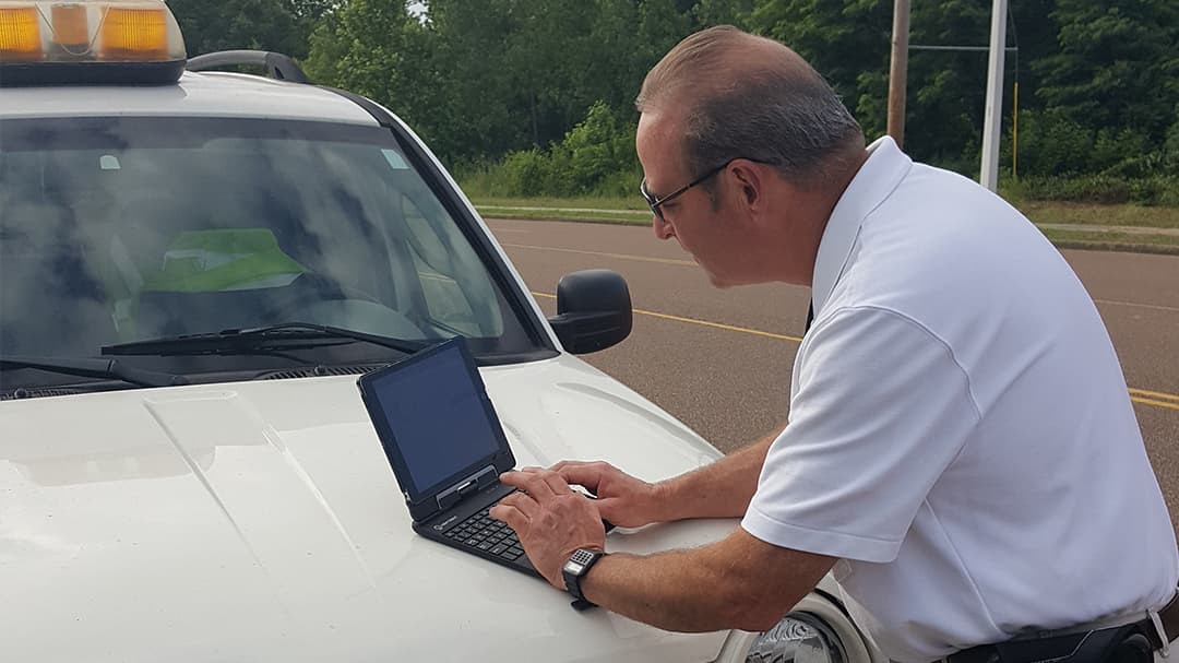
 Staff use ArcGIS applications to support inspection workflows.
.
Replacing manual processes
For a couple of years, inspectors used a digital form linked to a Microsoft Access database to collect information in the field. There was no map or visual representation of stormwater permits. Inspectors spent a lot of time searching and confirming that the correct permit was being referenced. When the form linked to the database stopped working, the inspectors began using paper. This resulted in inspections taking more time to complete and work being duplicated. Back at the office, the data collected on paper had to be manually entered into the Access database. No staff member knew how to fix the digital form, and there was no budget to hire someone. This led to discussions about how to replace the workflow with existing resources.
Engineering turned to GIS. I was asked if the old workflow could be replaced with GIS technology. I believed that GIS could support staff's needs. My first step was to learn more about mobile applications and how they could be configured and implemented. Using online resources and taking advantage of Esri blogs, I began to form an idea of what I wanted to do.
The next step was reaching out to our Esri account manager. She was able to connect me with a solution engineer, who helped by discussing the workflow, reviewing my proposed solution, and providing guidance when needed.
"The time being saved can now be used to make more detailed inspections and keep all parties compliant." Ricky Hobbs - Chief Engineering Inspector
Learning about Stormwater Inspections
Since I had never performed a stormwater inspection, I began meeting with engineering staff so that I could fully understand their needs. Identifying the order of the steps to their workflow, as well as the importance of the data collected, would help to create a digital form that staff would use. Once I thought that I understood, I wrote a two-page description of their work and what they needed to accomplish. The proposed solution was also described. Engineering staff reviewed and approved what I'd written.
One challenge in creating a useful solution was including a way for inspectors to quickly identify all the inspections associated with the permits for which they are responsible. Collierville manages permits by individual lots, but permits are not always issued by lot. They can be issued by builder and include many lots. To overcome this challenge, I configured the geodatabase using a feature class of permits with a one-to-many relationship to a table that held all the monthly stormwater inspections for each permit. The history of inspections for each stormwater permit is maintained in the table and is now readily available to the inspectors.
Putting GIS to the Test
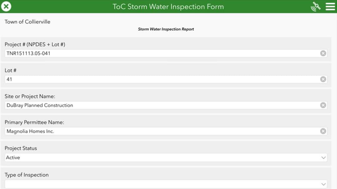
 ArcGIS Survey123 is used to collect inspection information.
The proposed solution included using ArcGIS Collector and ArcGIS Survey123 . A geodatabase was configured, using domains to support a new form. The form was built using Survey123 Connect. I took time to make sure that the format was exactly what engineering needed. In addition to specific data requirements, the form had to be as easy as possible to use. Using Survey123 Connect allowed me to be agile with the development and implementation of the form. The engineering staff reviewed it and provided changes until it was perfect. This agile approach was also used when configuring the web map for ArcGIS Collector.
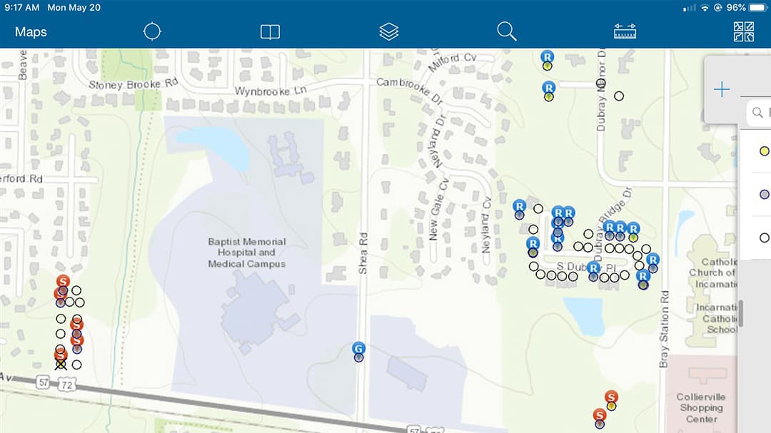
The inspectors use ArcGIS Collector to see where active permits are. Each permit shown in the map has a symbol next to it with the inspector's initials. This allows the inspectors to see who is assigned to each permit and inspection. When you click on an active permit, you are able to link to the Survey123 form to complete the inspection. The form allows inspectors to include up to five pictures. This is useful if they will need to return to the site for a second inspection. The process takes about 5–10 minutes per permit.
 ArcGIS Collector displays active permits for inspectors in the field.
The town's stormwater coordinator uses ArcGIS Online to edit data that is related to the inspection workflow. When new permits are issued, the coordinator adds them to the map, placing them in the correct location and providing contact information. Although I am the GIS manager, I do not manage this data. The stormwater coordinator is able to maintain and manage the data and make sure that it is ready for the inspectors. I only get involved if there are changes needed, which isn't that often—only about an hour per month.
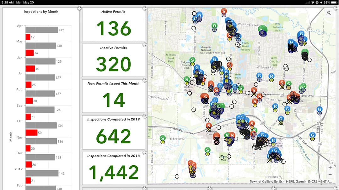
Engineering also uses a dashboard to monitor the work being done. The dashboard displays a map of the inspections and the number of inspections per month as well as how many inspections require reinspection and how much progress is being made by each inspector. An interesting result of using the dashboard was the discovery that a couple of months had higher numbers of reinspections than others. Staff wondered if there was higher rainfall during those months. Having the visual display provided insight that wasn't there before and inspired questions that led to looking more closely at the data.
Overall, it took about six months to fully implement the new workflow. I focused a lot of time on making sure that the map and form were easy to use. If the inspectors were not comfortable with the form, they wouldn't use it. My goal was to make their job easier with a simple solution that improved on what had been used in the past.
 ArcGIS Operations Dashboard configured to display a map of inspections, the number of inspections per month, and how many inspections require re-inspection.
Gaining the Benefits of Modernization
Collecting inspection information is easier and faster using ArcGIS Collector and ArcGIS Survey123. Here's how:
- On average, an inspection used to take 20 minutes. It now takes 5–10 minutes.
- Data quality has improved.
- Prepopulated fields ensure that the correct permit number and contact information are used with each inspection.
- Fewer data entry mistakes are made because the stormwater coordinator enters data directly into the GIS.
- Required fields are used to make sure that the mandatory information is collected.
- Engineering has a real-time view into the work being completed.
- An operational view helps managers understand the workload and helps the inspectors complete the work more efficiently.
- As monthly inspections are completed, symbols are added to the map to show if the permit is complete or if the site needs to be reinspected.
Finding Out What's Next
I am working on another dashboard that will clearly show sites that need to be reinspected within the month. In the recent past, inspectors would write in a log book the permits that required revisiting the site before the end of the month. Each of these inspections is now symbolized as a red X on a map. If the site passes inspection, the symbol becomes a black X.
This map will be shown on a dashboard along with a list of permits that need reinspections. I plan to create a link to Survey123 from the dashboard. If an inspector sees a reinspection assigned to them, they can zoom to the point in the dashboard and access Survey123 to perform the inspection. This will improve the workflow and prevent reinspections from being overlooked. Like the other changes, engineering staff have been involved. They review the dashboard and provide feedback. A couple of refinements still need to be made and then staff will begin using it.
I plan to evaluate ArcGIS Workforce, as it may improve our current workflow. I'll be reaching out to Esri again. If you're not talking to your Esri representative, you are missing out! The reps do a good job of supporting end users, providing advice and resources. Esri helps make it easy.