Accelerate the design process
Maintain data consistency and move beyond static regulatory practices by leveraging a GIS-based approach to data management and the organization of planning teams.
Shape the future of cities and regions

Many sites, many possible solutions. Land-use decisions are complex, requiring an increased awareness of current reality alongside fundamental tools to model the built environment. With rapid design iterations comes insight, the ability to understand potential trade-offs, and realistic solutions to vexing growth challenges.
ArcGIS Urban is a web-based 3D scenario planning software for cities and regions. It enables you to be more proactive and less reactive in your planning process and simplifies project collaboration for public and private stakeholders.
ArcGIS Urban is a web-based scenario planning tool for cities and regional agencies to test the impact of zoning and land-use changes and enable the creation of on-the-fly scenarios to help visualize the areas that would be impacted by proposed urban development.
Build out planning scenarios with 3D modeling directly in the web browser. Lay out a vision for any parcel, district, or neighborhood starting with a sketch. You can then further refine your designs with the help of interactive snapping and drawing guides.
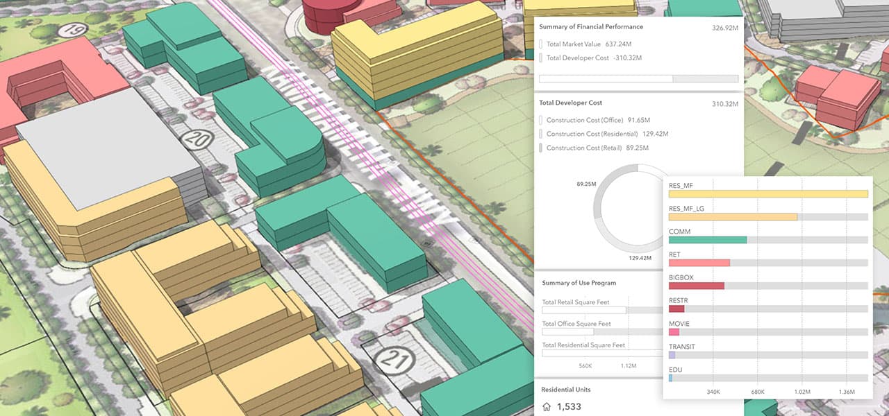
Real-time dashboards are a fundamental capability used to instantly calculate the impact of a build-out over time. Custom metrics enable you to calculate yield, estimate costs, and summarize value across your scenarios.
Working in the browser, you can compare current land-use with the proposed changes. By testing zoning proposals, such as rezoning or zoning variances, you can better evaluate short and long-term impacts to the community.
Overlay and weight themes related to population change, economic growth, residual zoning allowances, and other factors as a basis for understanding market conditions and site suitability.
Simplify the review planning scenarios by simulating the impact of shadow duration and viewshed. You can also create sectioned views of the model to reveal internal structures allowing you to measure the height and width of objects and buildings. Data, plus quantitative analysis, plus spatial analysis, equals a more informed approach to plan review.
Encourage collaboration with community stakeholders and help all groups work towards a more sustainable future.


We started off thinking of the model as a tool for communication, and after we built the model, we realized that it provided a way to study and share scenarios in a simple way that makes urban planning much more understandable.