Leveraging ArcGIS for sustainable conservation and geodesign
ArcGIS provides a complete system for advancing 30 by 30 initiatives around the globe to conserve 30 percent of land and waters by 2030. This session lays out Esri’s vision for enabling 30 by 30 from our leading experts in conservation, geodesign, and natural resource management. By unlocking vast collections of relevant spatial data with geographic science, ArcGIS can provide a framework for local and national conservation planning efforts.
Hear from Esri’s thought leaders, including:
- David Gadsden, Director of Conservation Solutions
- Ryan Perkl, PhD, Green Infrastructure Lead Principal Consultant, Environment and Geodesign
- Sunny Fleming, National Solution Engineer, State Environment
- Daniel Martin, Consultant and Project Manager, Environment and Geodesign
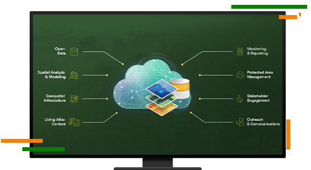
Geospatial infrastructure for 30 by 30
Geospatial infrastructure is essential to supporting organizations and Indigenous communities working to achieve 30 by 30 initiatives. ArcGIS provides spatial references for holistic conservation planning, incorporating inclusive community feedback to evaluate scenarios for sustained landscape conservation.