CSS updates media query updates. Verify no visual or functional issues.
Identify problems
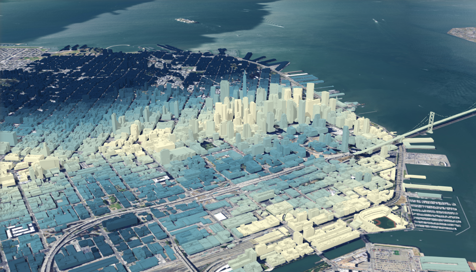
Use GIS to illuminate issues that are driven by geography. This map of opioid prescription claims reveals the geographic patterns that emerge when data is well-mapped.
View an opioid epidemic map
Monitor change
If a picture tells a thousand words, a map tells a thousand pictures. This map starkly reveals the extent of glacier retreat in the Southern Hemisphere.
Look at the Patagon Journal Memories of Ice map
Manage & respond to events
GIS delivers real-time situational awareness. This hurricane and cyclone map shows potential impact to people and businesses, probable track of storms, and storm surge.
Try the Hurricane and Tropical Cyclones map
Perform forecasting
Use GIS to forecast traffic. This map highlights challenges at an intersection in Fort Mitchell, Kentucky, where forecasting shows traffic is expected to worsen based on land use changes.
Open the NKYmapLAB interactive map
Set priorities
GIS helps to set priorities based on spatial analysis. By analyzing crime patterns, public safety officials can identify target areas and assign officers in those areas.
Take a look at a crime response map
Understand trends
GIS helps you gain insight into data that might be missed in a spreadsheet. This map measures job growth or losses in different industries and quantifies local competitive advantage.
Try the shift-share analysis map
Cards Container v3 with Cards Editorial
CSS updates media query updates. Verify no visual or functional issues. Click on Play button, verify no visual or functional issues.
Call to action
Featured
Category Text
Hero Card 1
Context
This Content Box is NOT a rich-text editor.
Featured: (optional) plain text with 30 characters max.
Title: (required) plain text with 80 characters max.
Content (required) plain text with 400 characters max.
Category Text (optional) plain text with 35 characters max.
Context (optional) plaint text with 45 characters max.
Asset Type (optional) Image/Video. Image either JPEG or PNG format.
Primary Link Label
Secondary Link Label
Featured
Conservation
Conservation Outreach
Context
Conservation Outreach can be used to track wildlife conflicts and engage stakeholders in and around protected areas.
Next Solution
Product Solution
Readiness
Readiness Management
Context
Readiness Management can be used to understand and communicate comprehensive unit and force readiness.
One Solution
Two Solution
Intelligence
ArcGIS Pro Intelligence
Context
ArcGIS Pro Intelligence can be used to visualize, explore, and analyze disparate data to produce actionable intelligence.
Primary Link Label
Secondary Link Label
Featured
Conservation
Conservation Outreach
Context
Conservation Outreach can be used to track wildlife conflicts and engage stakeholders in and around protected areas.
Next Solution
Product Solution
Anterior
Siguiente
Call to action
Category
Esri Text
Subtitle
Verify Category is uppercase.
sticky dialog bar
Brandbar title
Vivamus bibendum semper sapien at congue. Curabitur auctor libero nec ush icuhsi uhfic uhso uhfc iouh oscvu8h