|
|
||
|
|
|
|
|
|
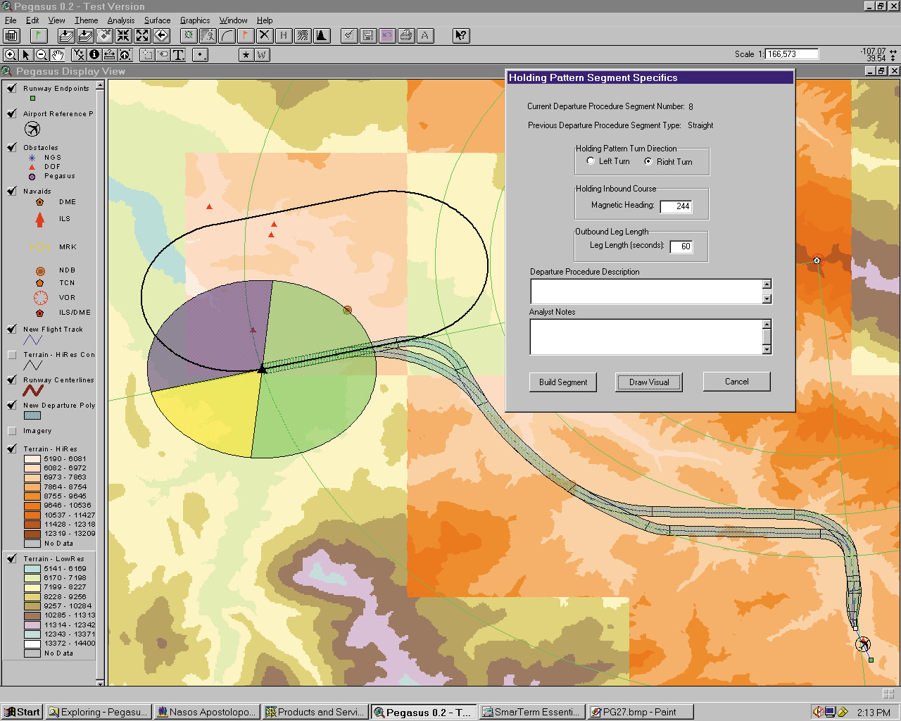
Jeppesen's Pegasus System Helps Manage More than 15,000 RunwaysRunway Analysis Implemented with GISJeppesen, a Denver-based company, is a leading supplier of flight information, supported by flight planning services, aviation weather services, maintenance information, and pilot training systems. In 1997, the company needed a GIS designed to automate the company's labor-intensive runway analysis processes. BackgroundFor more than 20 years, Jeppesen's Operations Data (OpsData) department has been a leading supplier of aircraft performance information and airport analysis that allows operators to comply with regulatory requirements for engine-out performance. These regulations require a calculation of maximum aircraft cargo weight. Maximum At right: The display and analysis modules provide dialogs that allow the user to choose and build the most suitable holding patterns based on the aircraft's spatial positioning. The visual presentation of data allow the user to direct the aircraft around terrain and obstacle features with the use of navigational aids. Additionally, airport analysis calculates engine-out cargo weights for a range of temperatures. The calculation is further customized for a particular aircraft/engine configuration for a specific runway at a given airport. The analysis considers such variables as flap setting, various aircraft characteristics, runway conditions, obstacle clearance, and winds. To this end, OpsData maintains a database of more than 15,000 runways. In the past, in order to ensure obstacle clearance, Jeppesen had to manually perform a detailed obstacle analysis for the engine-out departures for every runway at a given airport. That process took days. "Runway analysis was a very laborious and time-consuming task, as obstacle source data comes in different formats," says Nasos Apostolopoulos, senior analyst and supervisor of the OpsData department. "Each source had to be individually evaluated to determine the impact on aircraft performance. This evaluation involved painstaking manual measurements and plotting on paper. The process was repeated several times until every source had been evaluated. We needed a system that could integrate multiple layers of source data and extract pertinent data as needed to automate OpsData production." The Pegasus SystemUsing ArcView GIS, ArcView Spatial Analyst, and ArcInfo, Idea Integration, an e-Business solutions provider and Esri Business partner, developed the Pegasus system. By utilizing the geometric constructs available in ArcView GIS, Jeppesen is now able to perform that analysis in minutes. Now digital terrain, obstacle, airport, navigation, and cultural (e.g., towers, roads, housing) data can be seamlessly integrated to analyze departure tracks in accordance with applicable aviation regulatory requirements. "With the integration of GIS into our operations, we were able to increase productivity by 400 percent due to the reduction of time it takes to analyze takeoff paths," says Apostolopoulos. "Accurate and precise analysis of aeronautical, geographic (terrain), and obstacle data is mission critical; so we are constructing a central repository of worldwide geospatial information that will be able to meet the present and emerging demands for airport GIS, airport and runway procedure analysis, and en route and terminal terrain avoidance." Included in the Pegasus system are interfaces that help Jeppesen manage and visualize raster and vector data by providing display, analysis, change management, and edit modules that can access a centralized data warehouse over a wide area network. The display module allows a user to retrieve previously stored airport analyses and aircraft departure procedures for display in ArcView GIS. Tools are provided to allow the production of tabular reports and layouts. The analysis module has tools that assist the user in creating custom or standard aircraft departure procedures using navigational aids and visual terrain verification. Once such a procedure is constructed, the user can analyze all obstacles in that flight path. This allows Jeppesen to identify and avoid critical obstacles and noise-sensitive areas, increase maximum takeoff weights, and integrate engine-out procedures into the analysis. The change management module provides tools that allow the user to compare all previously stored procedures against any changes in the obstacle database and produce a report of those procedures possibly affected. The edit module contains tools that allow the user to add, delete, and modify any polygon, polyline, and point features in the data warehouse. Jeppesen, a Boeing company, has offices in the United Kingdom, Germany, Australia, China, and other United States locations. For more information, contact Nasos Apostolopoulos at Jeppesen (tel.: 303-799-9090, ext. 4405; e-mail: nasos@jeppesen.com) or Erik Dorsett at Idea Integration (tel.: 800-685-5566; e-mail: erik.dorsett@idea.com). |