
Powerful Multiuser Editing with Sophisticated Data Integrity Tools
ArcEditor Manages Geodatabase Schema and Includes Advanced Editing of Geodatabases and Coverages
ArcEditor is a new software product introduced with the ArcGIS 8.1 family of software. The functionality of ArcEditor 8.1 places it between ArcView 8.1 and ArcInfo 8.1. ArcEditor contains all the features of ArcView while adding capabilities for managing geodatabase schema and advanced editing of geodatabases and coverages. ArcEditor can create and edit all Esri-supported vector data formats including shapefiles, coverages, personal geodatabases, and multiuser geodatabases.
Advanced map display and analysis.
ArcEditor comprises the same three applications found in ArcView 8.1 and ArcInfo 8.1: ArcMap for superior cartography, map analysis, and editing; ArcCatalog for organizing, previewing, and managing GIS data; and ArcToolbox for geoprocessing and data conversion tools. Additional functionality is enabled in each of the component applications (ArcMap, ArcCatalog, and ArcToolbox) as the user moves up the line from ArcView to ArcEditor and finally to ArcInfo. Since ArcEditor shares the same applications and user interface with ArcView 8.1 and ArcInfo 8.1, it is easy for users to move between applications depending on their role or task at hand.
ArcEditor includes all the functionality of ArcView 8.1, as well as the following:
- Centralized management of a wide variety of geographic information in a DBMS.
- Large data management in a continuous integrated environment (raster/vector).
- Full support for multiuser editing in an advanced versioning environment.
- Support for advanced data types and geometry (i.e., the ability to store three-dimensional coordinates, measures, and true curves).
- Edit all Esri vector data formats including coverages and ArcSDE geodatabases.
- Faster and more efficient data entry with data rules and relationships.
- Create and edit feature-linked annotation.
- Create and edit geometric networks.
- Create relationships with tabular data sources stored in any industry-standard DBMS.
- Create and edit topologically integrated features.
- Create subtypes and domains for maintaining database integrity.
- Supports the development of industry-standard data models.
- Enable automatic geodatabase validation.
- Create and edit coverages.
- Create and edit INFO files.
- Vector features with two, three, and four dimensions (x,y,z, and m).
Sophisticated feature editing with rules and relationships.
The Geodatabase
ArcEditor supports the sophisticated data format known as the geodatabase (first introduced with ArcInfo 8.0.1). The geodatabase is similar to an ArcInfo coverage. A 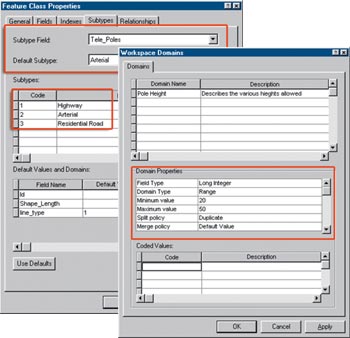 geodatabase is a storage mechanism for spatial and attribute data that contains specific storage structures for features, collections of features, attributes, relationships between attributes, and relationships between features.
The geodatabase comes in two varieties--personal and multiuser. Personal database support is built into ArcGIS implemented with Microsoft Jet, stored in a Microsoft Access file, and is suitable for project-level GIS. Multiuser databases are deployed using ArcSDE and require a database management system (DBMS) such as IBM DB2, Informix, Microsoft SQL Server, or Oracle.
The geodatabase, whether personal or multiuser, can store tables, feature classes, feature data sets, and functionality such as rules, relationships, and geometric networks. Geodatabases can be created, accessed, and managed through the standard menus and tools in ArcCatalog, ArcToolbox, and ArcMap.
Centralized GIS Data Management
The first key feature of the geodatabase is the centralized storage of a wide variety of geographic information in a DBMS. This is the natural solution for handling the growing amount of digital spatial data and also meets the need to leverage this data among the growing numbers of GIS users. The geodatabase supports multiple formats of spatial data including
- Simple features such as shapefiles
- Custom features with Business logic and editing rules
- Attribute data
- Metadata
- Images
- Raster/Grid data
- CAD data
Multiuser Editing
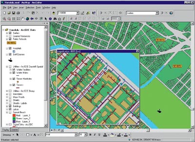
The geodatabase can be used for multiuser access to databases storing continuous (nontiled) spatial data through the use of versioning and long transactions. Many users can read and write to the same database at the same time (subject to DBMS permissions). They can also work on secure edit sessions that span weeks, months, or even longer.
Edit Integrated Features
Topologically associated feature classes in a geodatabase are stored in an integrated feature data set. The user can use the topological editing tools (such as the Shared-Edge edit tool) in ArcMap to maintain the topological associations of features in an integrated feature data set. Since most vector data sets have features that share common boundaries or corners, the ability to directly edit all of these features within one spatially common feature data set is a huge plus for the GIS community.
Maintain Database Integrity
By managing the data in a geodatabase with ArcEditor, the analyst can define rules about how the data can be edited. Using the geodatabase, any user can set up subtypes, which define categories for feature datasets. Subtypes can ultimately increase data entry efficiency by providing the data entry clerk with more control over edited features. The user can also set up domains which control the allowable set of values that may be input for any field in a geodatabase table. This limits the possibility of data entry error because the choices for each data value are limited within defined parameters. To learn more about subtypes and domains, see the April-June 2000 issue of ArcUser, which is available online (www.esri.com/arcuser).
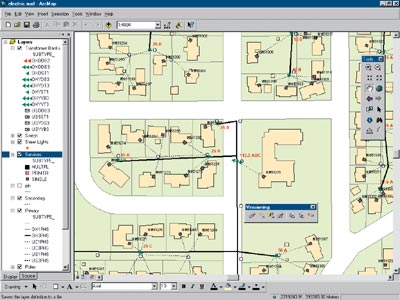
Geometric Networks
With the ArcCatalog Geometric Network Wizard, line and point feature classes in a single feature data set can be organized into a geometric network. The network combines the line and point feature classes into a single database entity in order to model linear networks--for example, electrical networks--and maintains topological relationships between the participating feature classes. The geometric network automatically maintains the explicit topological relationships between network features in a geometric network.
ArcEditor brings together the vast mapping features included with ArcView and combines them with sophisticated data editing and data integrity maintenance capabilities within the geodatabase. ArcEditor effectively integrates the superior mapping functionality found throughout the ArcGIS Desktop software products, with an extensive multiuser editing environment and sophisticated data integrity tools.
Find out more about this robust mapping software at www.esri.com/arceditor.