
Extended GPS Support
ArcPad 6 Release
ArcPad 6, the latest release of Esri's mobile GIS technology, provides several major enhancements including a new development software product, extended GPS support, enhancements to key functions including editing, internationalization and localization, and continued growth as a mobile client in the ArcGIS family of products.
Customization with the ArcPad Application Builder
The major focus of the ArcPad 6 release is to enable user customization with the new ArcPad Application Builder. The ArcPad Application Builder includes a desktop 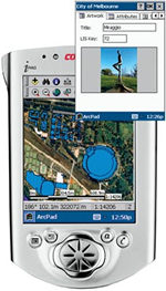 customization application called ArcPad Studio. ArcPad Studio enables users to add and remove buttons on the user interface; modify existing toolbars; create custom forms for data capture; and create scripts, applets, DLLs, or extensions for advanced customization such as support for new data formats. All customization for ArcPad is performed on the desktop and deployed on the mobile device. The ArcPad Application Builder includes a copy of ArcPad Studio, ArcPad 6, and first year's maintenance.
Right: Modify existing toolbars using the ArcPad Application Builder Edit form with image box. Add an image to your custom forms.
GPS Support
GPS support for basic navigation and GPS data capture at ArcPad 6 is extended worldwide to all receivers that support any of the following GPS protocols: NMEA, TSIP (Trimble's binary protocol), PLGR, and the DeLorme Earthmate binary protocol. In addition, ArcPad 6 includes new options for setting GPS quality controls, such as PDOP and EPE.
Enhancements
ArcPad 6 provides additional enhancements to the following key areas: editing, query, navigation, and map display. At version 6, the editing capabilities are extended with tools to add, delete, and move vertices for lines and polygons; tools to append vertices to existing line features; and support for point mode digitizing with a pen or GPS input. The addition of spatial bookmarks and tools to pan and zoom to a specified coordinate will improve map navigation capabilities. Map display and symbolization will include support for graduated symbols and colors, labeling of lines and polygons, and raster symbols.
Internationalization and Localization
ArcPad 6 supports multibyte character set (MBCS) data stored in a shapefile attribute field as well as conversion between MBCS and UNICODE. Display of data in UNICODE, such as Japanese and special European characters, will be available depending on the device. Localized versions of ArcPad will be available for a number of languages and countries.
Mobile Client for ArcGIS
Another important enhancement to ArcPad 6 is the creation of ArcPad tools for ArcGIS 8.1. This allows users to extract, convert, and project their data using ArcGIS desktop software products (ArcView, ArcEditor, and ArcInfo).
Availability
ArcPad 6 and the ArcPad Application Builder will be available in the fall of 2001. ArcPad supports Windows CE 2.11, 2.12, and 3.0. ArcPad also runs on Windows 95/98, NT, and 2000 platforms.
For more information, visit www.esri.com/arcpad or call Esri at 1-800-447-9778. To download a free evaluation copy or to order ArcPad in the United States, call Esri at 1-800-447-9778, call your Esri regional office, or contact your local reseller. Outside the United States, please contact your local Esri distributor.