
Colorado Utility Maps in the Rockies with Imagery
Colorado Springs, Colorado, is located at the foot of Pike's Peak at an altitude of 6,035 feet. According to the City's Chamber of Commerce, this picturesque community thrives on tourism, high technology, manufacturing, sports, and the military. Colorado Springs recently crossed the 500,000 mark in population, ranking it in the top 100 largest cities in the United States and the 18th fastest growing city.
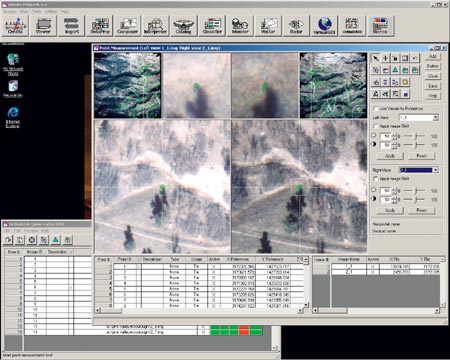
Ground control and tie points associated with flight line one for the Homestake pipeline can be identified and verified using the point measuring tool in IMAGINE OrthoBase.
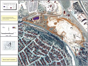
Data courtesty of the Colorado Springs Utilities Water Resources Department.
Serving the area and its citizens with natural gas, electricity, and waste and water management is the job of the Colorado Springs Utilities (CSU). Historically, the utility has been divided into four organizations, but new initiatives are under way to combine the four into one, thereby streamlining the management of all utility services and geographic information under its wing.
The GIS section of CSU has been building and managing the ArcInfo-based GIS since 1988. The vector-based system is used primarily to identify and map lot boundaries, buildings, and streets and for facility mapping of its pipes, valves, and meters. Basemaps to support the GIS were traditionally created by outside consultants who were commissioned to gather aerial photographs and orthorectify the imagery.
 CSU faced new challenges when, in the summer of 1999, the Water Resources Department had a multimillion dollar problem: they needed to accurately and inexpensively create new maps using high-resolution aerial photography that detailed--down to a six-inch pixel resolution--their two raw watersheds, water treatment complex, and two buried pipelines that stretch about 180 miles through the Rocky Mountains.
Above right: A finished map with an orthophoto of the Sand Creek Pumpstation after processing with ERDAS IMAGINE and ArcInfo.
Following an extensive evaluation of the project requirements and time line, they decided to bring the processing in-house by using ERDAS' geographic imaging solutions for collecting, editing, and creating three-dimensional ortho-accurate maps and merging that data with their ArcInfo GIS.
For the first time, the CSU Water Resources Department has a set of ortho-accurate, high-resolution maps (scale of one inch equals 200 feet) that detail the location of the underground pipelines, watersheds, reservoirs, and hydroelectrical facilities that they own and maintain, as well as the associated property information. Furthermore, the data gained at the raw water treatment complex will help them assess expansion capabilities at their north water treatment complex.
Even more importantly, by completing the two mapping projects in-house, the CSU Water Resources Department saved an estimated $1.8 million. CSU estimates that had the map projects been outsourced, the projects would have cost more than $2 million. The ability to process more high-resolution imagery in-house will help CSU to cost-effectively and efficiently maintain their GIS and enable them to keep pace with ever-changing environmental regulations and safety laws associated with wastewater and natural gas management.
Mountain Pipeline Distribution Project
Settled beneath layers of snow and ice on the Colorado Rockies, pipelines that total more than 200 linear miles deliver raw water from collection sites set high on top of the northern, southern, and western mountain slopes to the springs and lakes below. However, knowing precisely how every inch of the pipelines coincides with such issues as private landowner easements, public roadways, fencing, lakes and streams, and housing developments is a challenge faced by the Water Resources Department.
 Using Stereo Analyst and ERDAS IMAGINE, the Water Resources Department is capturing data on roughly 130 miles of the 200-mile pipeline to create their basemaps, and they are then combining the resulting data with GPS and pipeline data to create an accurate set of detailed maps. The compatibility between ERDAS and Esri products is important to this Esri-based shop because, according to Mike White, senior GIS analyst for the CSU Water Resources Department, "we have all of Esri's products and use them when and where appropriate."
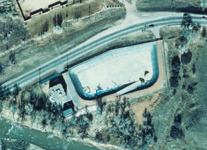
Above left: An orthophoto of the Wastewater Sand Creek pumpstation at the south end of Colorado Springs. Data courtesy of the Colorado Springs Utilities Water Resources Department.
Using the appropriate Esri GIS technology, the image-based maps will then be used to chart details of the pipelines such as accessibility, maintenance history and schedules, and future water needs. The maps will also be used to monitor land use to ensure that developers seeking to build on the exclusive pristine perches do not do so on top of a 60-inch water main easement.
"Having this information really helps our people in the field deal with planning issues such as leaks, growth, and maintenance," explains White. "They have to know which landowners to contact when they need to get to the pipeline. They have to know where the easements are, where lot boundaries are, and how to access the pipe."
By creating high-quality orthophotos in-house, CSU anticipates cutting the cost of the pipeline project by 90 percent and completing it several months earlier than if the project had been outsourced.
"Using ERDAS' products has allowed us to control the level of quality of each mapping project depending on specific project requirements," notes White.
Based on his previous experience with outsourced basemapping projects, White estimates the project would have cost approximately $2 million if it had not been brought in-house. Using the ERDAS products in-house, the project--including the cost of the software, equipment, and labor--will total about $200,000.
White estimates the entire pipeline project will take about a year to complete.
Water Treatment Project
The Water Resources Department is also using imagery to create highly detailed maps of a water treatment plant on the north end of Colorado Springs. The data collected will help with planning issues such as maintenance, future consumption needs, and expansion viabilities.
 Another phase of the water treatment map project involved collecting accurate three-dimensional data on the 25-megawatt tesla hydroelectric plant, built at the mouth of the underground pipeline in 1997. Water collected from the Rampart Reservoir is brought to the plant by the pipeline. The movement of water turns a water wheel, which turns the turbine and generator to make electricity. The water energy harnessed from the hydroelectric plant will create pollution-free energy.
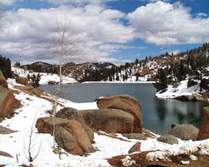
Above right: Raw water distribution reservoirs just downstream of Nichols Reservoir. These reservoirs are used to store and capture water for distrubiont ot water treatment plants. Photo courtesy of the Colorado Springs Utilities Water Resources Department.
The Water Resources Department is planning to use the data gathered to upgrade the facility.
Mapping the water treatment plant was completed in about two weeks and cost about $3,500. Had the project been outsourced, White estimates it would have cost about $50,000.
The ERDAS Solution
White said the Water Resources Department is pleased with the quality of the data that has been collected.
"We were looking for a solution to help us map our mountain data," said White. "The ERDAS software does exactly what ERDAS said it would do and what we needed it to do."
CSU is able to create and maintain their GIS using ortho-accurate information and a linear work flow with the powerful combination of IMAGINE Advantage, IMAGINE OrthoBASE, Stereo Analyst, and IMAGINE VirtualGIS.
Because the ERDAS products have met CSU's expectations, White said they are eager to use the new release of IMAGINE OrthoBASE Pro, a tool that will automatically extract elevation information from imagery--a powerful time-saving feature.
For more information, contact Mike White, Colorado Springs Utilities (tel.: 719-668-8751, e-mail: mwhite@csu.org). See also sidebar, "Verifying Total Irrigated Acreage with GIS."