
Connecticut Telecommunications Planning Aided by GIS Mapping
By Joel M. Rinebold, Executive Director, Connecticut Siting CouncilSince the mid-1980s, cellular and other wireless telecommunications providers have been erecting telecommunications towers to provide wireless telephone service. The  regulation and development of these wireless telecommunications towers have become a challenging responsibility for local land use officials throughout the world. The problems with the development of wireless telecommunications towers include public opposition due to concerns over health, safety, visual impairment, and effect on nearby land values.
Right: Unique examples of integrating facilities into the community include disguising towers as flagpoles, trees, and farm silos.
Although the regulation and siting of telecommunications towers have been strained, the public demand for wireless service has grown with more than one billion wireless telephone users expected worldwide by 2005. This demand will result in an urgent need to construct new transmitting facilities including more than 100,000 new facilities in the United States alone, many of which will require tower structures. With the more than 100,000,000 wireless subscribers in the United States growing at a rate of more than 50,000 new subscribers each day, land use regulators will be faced with the onerous task of regulating the siting of new towers quickly and efficiently while protecting community and environmental interests.
Too often, local land use officials are poorly equipped to analyze radio frequency propagation and to test potential coverage from alternative sites.
Project Planning
The Connecticut Siting Council, a Connecticut State agency, has met this challenge in Connecticut by systematically regulating the placement of new towers and exploring alternatives to new towers. The process, developed by the Council and the Connecticut General Assembly, includes provisions for municipal consultation, propagation modeling, GIS mapping, facility planning, and an evidentiary proceeding to decide on applications. Consistent with this process, nearly one half of all Connecticut communities have cooperated with the Council to develop Telecommunications Plans of Development to guide where and how towers are constructed. The process includes using ArcView GIS to map all towers, detailed propagation modeling from existing towers, and the identification of new facility sites in areas that cannot be served by existing towers. These Telecommunications Plans of Development all have common elements to share existing towers and structures whenever possible, but all are uniquely tailored to the community.
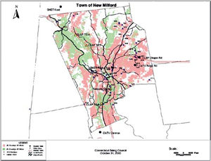 For example, the Telecommunications Plans of Development established by the Town of New Milford uses a strategy to collocate facilities within existing electric transmission line rights-of-way. Another strategy frequently used by municipalities is to use town-owned land for the development of towers that can also be used for public safety communications. The Council has also worked with councils of government; regional planning agencies; multiple towns, such as Sharon and Cornwall; and the Appalachian Trail Conference to identify the least obtrusive site locations within scenic corridors. Ann Sherwood, chairman of the Trails Committee of the Connecticut Chapter of the Appalachian Mountain Club, is pleased to see a systematic approach used to protect invaluable resources such as the Appalachian Trail.
Above left: The mapping of radio frequency propagation will help determine where, at what height, and what type of structure alternatives exist to provide wireless telecommunications.
Careful planning of towers and placement of antennas on existing structures minimize the need for construction of new facilities to avoid unnecessary cost and potential public opposition. Harry Eberhart, a town planner who has worked in several Connecticut towns, agrees that many municipalities could not have managed the information without the system put into place by the Council. Unique examples of integrating facilities into the community include disguising towers as flagpoles, trees, and farm silos; the collocation of transmitting antennas on existing towers, buildings, and other tall structures; and the placement of antennas on electric transmission lines within existing utility rights-of-way.
Technical Design
The technical tools that the Council uses include ArcView GIS 3.2 on a UNIX platform with the ArcView Spatial Analyst extension, coupled with a radio frequency propagation modeling program to determine where such telecommunication facilities are needed, at what height they should be developed, and how each facility can be integrated within a network of existing facilities. These programs, used with ArcView Spatial Analyst, are intended to model radio signal strength over existing databases of topography but also provide an opportunity to consider the visual effects of new towers on sensitive environmental resources such as protected mountain ridge zones, sensitive river corridors, historic sites, and archaeological areas. The use of ArcView GIS 3.2 and ArcView Spatial Analyst supports critical dissemination of information, provides a platform for mapping, and is compatible with the GIS systems used by many municipal planning departments for integration into comprehensive master plans.
For more information, contact Joel M. Rinebold, executive director; Paul Aresta, siting analyst 2; or Christina Le Page, siting analyst, Connecticut Siting Council (tel.: 860-827-2935, fax: 860-827-2950, Web: www.state.ct.us/csc/index.htm).